Country:
Region:
City:
Latitude and Longitude:
Time Zone:
Postal Code:
IP information under different IP Channel
ip-api
Country
Region
City
ASN
Time Zone
ISP
Blacklist
Proxy
Latitude
Longitude
Postal
Route
Luminati
Country
Region
vc
City
lalfasdelpi
ASN
Time Zone
Europe/Madrid
ISP
Dragonet Comunicaciones SL
Latitude
Longitude
Postal
IPinfo
Country
Region
City
ASN
Time Zone
ISP
Blacklist
Proxy
Latitude
Longitude
Postal
Route
db-ip
Country
Region
City
ASN
Time Zone
ISP
Blacklist
Proxy
Latitude
Longitude
Postal
Route
ipdata
Country
Region
City
ASN
Time Zone
ISP
Blacklist
Proxy
Latitude
Longitude
Postal
Route
Popular places and events near this IP address

Benigembla
Municipality in Valencian Community, Spain
Distance: Approx. 4893 meters
Latitude and longitude: 38.75583333,-0.11027778
Benigembla (Valencian pronunciation: [beniˈdʒembla]) is a town and municipality located in the Pop Valley within the district of Marina Alta in eastern Spain. The town is 314 m above sea level. It is only 50 km away from Benidorm, 88 km from Alicante, 105 km from Valencia, and 23 km from Dénia.

Bolulla
Municipality in Valencian Community, Spain
Distance: Approx. 6904 meters
Latitude and longitude: 38.67638889,-0.11222222
Bolulla (Valencian pronunciation: [boˈluʎa]) is a Valencian town and municipality located in the comarca of Marina Baixa, in the province of Alicante, Spain. Bolulla has an area of 13.6 km2 and, according to the Spanish National Statistics Institute, a total population of 421 inhabitants at 1 January 2014 (of which 241 Spaniards and 180 foreigners). The economy of Bolulla is exclusively based on agriculture.
Jalón
Municipality in Valencian Community, Spain
Distance: Approx. 4990 meters
Latitude and longitude: 38.74055556,-0.01222222
Xaló (Valencian: [ʃaˈlo]; Spanish: Jalón Spanish: [xaˈlon]), is a municipality in the comarca of Marina Alta in the Valencian Community, Spain.
Benidoleig
Municipality in Valencian Community, Spain
Distance: Approx. 7752 meters
Latitude and longitude: 38.79166667,-0.0325
Benidoleig (Valencian pronunciation: [beniðoˈletʃ]) is a municipality in the comarca of Marina Alta in the Valencian Community, Spain. Benidoleig is located in the Girona Valley of the Marina Alta area in Spain's Costa Blanca. Among the various amenities within the village is a junior/infant school, nursery school (local authority run), medical centre, post office (open 1 hour per day), supermarket, tobacconist/newsagents, hardware store, curtain shop, hairdresser, estate agent/sign shop, printers, bank, pharmacy and various Spanish bars.
Tàrbena
Municipality in Valencian Community, Spain
Distance: Approx. 4650 meters
Latitude and longitude: 38.695,-0.10083333
Tàrbena (Valencian pronunciation: [ˈtaɾbena], Spanish: Tárbena) is a municipality in the comarca of Marina Baixa, Alicante, Valencia, Spain.

Taifa of Dénia
Islamic kingdom in medieval Spain
Distance: Approx. 8995 meters
Latitude and longitude: 38.75,-0.1667
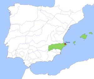
The taifa of Dénia (Arabic: طائفة دانية) was an Islamic kingdom in medieval Spain, ruling over part of the Valencian coast and Ibiza. With Dénia as its capital, the taifa included the Balearic Islands and parts of the Spanish mainland. It was founded in 1010 by the Slavic Muslim warlord Mujāhid al-ʿĀmirī.

Llíber
Distance: Approx. 7701 meters
Latitude and longitude: 38.75,0.01666667
Llíber is a village in the province of Alicante and autonomous community of Valencia, Spain. The municipality covers an area of 21.9 square kilometres (8.5 sq mi).
Murla
Distance: Approx. 2505 meters
Latitude and longitude: 38.75,-0.06666667
Murla is a village in the province of Alicante and autonomous community of Valencia, Spain. The municipality covers an area of 5.81 square kilometres (2.24 sq mi) and as of 2022 had a population of 540 people.
Sagra, Spain
Distance: Approx. 9278 meters
Latitude and longitude: 38.81083333,-0.06555556
Sagra is a village in the province of Alicante and autonomous community of Valencia, Spain. The municipality covers an area of 5.6 square kilometres (2.2 sq mi) and as of 2011 had a population of 454 people.

Tormos
Municipality in Valencian Community, Spain
Distance: Approx. 8269 meters
Latitude and longitude: 38.80166667,-0.0725
Tormos is a municipality in the province of Alicante and autonomous community of Valencia, Spain. The municipality covers an area of 5.3 square kilometres (2.0 sq mi) and as of 2011 had a population of 383 people.

La Vall de Laguar
Municipality in Valencian Community, Spain
Distance: Approx. 6641 meters
Latitude and longitude: 38.77694444,-0.11
La Vall de Laguar is a chain of three village in the province of Alicante and autonomous community of Valencia, Spain. The villages are, from the lowest and first encountered if entering the Val from the town of Orba, the most usual route, Campell, Fleix and Benimaurell. The municipality covers an area of 22.96 square kilometres (8.86 sq mi) and as of 2011 had a population of 961 people.
Castle of Aixa
Castle in Xaló municipality, Spain
Distance: Approx. 6934 meters
Latitude and longitude: 38.7614,-0.0002
Castle of Aixa, also known as Castell de la Solana (not to be confused with the current country house in Alcalalí named Castell de la Solana), consists of the remains of the ancient castle in the mountains of the Castellet de Aixa in the highest part of Beniquesi, a location in the municipal district of Alcalalí (Spain), 600 meters above sea level, between Llosa de Camacho and Jalón and covering the entire Pop Valley. The castle is in ruins and only some remains of its base and walls can be seen. Its rectangular tower of 12 by 4 meters has three shallow pools and a fountain.
Weather in this IP's area
overcast clouds
14 Celsius
14 Celsius
12 Celsius
15 Celsius
1021 hPa
88 %
1021 hPa
974 hPa
10000 meters
3.29 m/s
4.74 m/s
37 degree
96 %
07:42:59
17:47:06


