Country:
 Germany
Region:
City:
Latitude and Longitude:
Time Zone:
Postal Code:
IP information under different IP Channel
ip-api
Country
Region
City
ASN
Time Zone
ISP
Blacklist
Proxy
Latitude
Longitude
Postal
Route
IPinfo
Country
Region
City
ASN
Time Zone
ISP
Blacklist
Proxy
Latitude
Longitude
Postal
Route
MaxMind
Country
Region
City
ASN
Time Zone
ISP
Blacklist
Proxy
Latitude
Longitude
Postal
Route
Luminati
Country
DERegion
sh
City
kiel
ASN
Time Zone
Europe/Berlin
ISP
TNG Stadtnetz GmbH
Latitude
Longitude
Postal
db-ip
Country
Region
City
ASN
Time Zone
ISP
Blacklist
Proxy
Latitude
Longitude
Postal
Route
ipdata
Country
Region
City
ASN
Time Zone
ISP
Blacklist
Proxy
Latitude
Longitude
Postal
Route
Popular places and events near this IP address

Kiel
German city, capital of Schleswig-Holstein
Distance: Approx. 2576 meters
Latitude and longitude: 54.32333333,10.13944444
Kiel ( KEEL, German: [kiːl] ) is the capital and most populous city in the northern German state of Schleswig-Holstein, with a population of 246,243 (2021). Kiel lies approximately 90 kilometres (56 mi) north of Hamburg, and about the same distance south of the Danish border. Due to its geographic location in the southeast of the Jutland peninsula on the southwestern shore of the Baltic Sea, Kiel has become one of Germany's major maritime centres, known for a variety of international sailing events, including the annual Kiel Week, which is the biggest sailing event in the world.
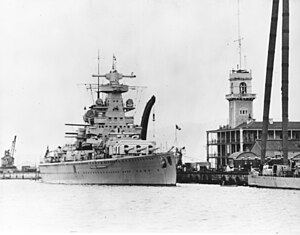
German cruiser Admiral Scheer
German warship, 1934–45
Distance: Approx. 1930 meters
Latitude and longitude: 54.32055556,10.16388889
Admiral Scheer (German pronunciation: [atmiˈʁaːl ˈʃeːɐ̯]) was a Deutschland-class heavy cruiser (often termed a pocket battleship) which served with the Kriegsmarine (Navy) of Nazi Germany during World War II. The vessel was named after Admiral Reinhard Scheer, German commander in the Battle of Jutland. She was laid down at the Reichsmarinewerft shipyard in Wilhelmshaven in June 1931 and completed by November 1934. Originally classified as an armored ship (Panzerschiff) by the Reichsmarine, in February 1940 the Germans reclassified the remaining two ships of this class as heavy cruisers.

Howaldtswerke-Deutsche Werft
German shipbuilding company
Distance: Approx. 1744 meters
Latitude and longitude: 54.31888889,10.15555556
Howaldtswerke-Deutsche Werft (often abbreviated HDW) is a German shipbuilding company, headquartered in Kiel. It is part of the ThyssenKrupp Marine Systems (TKMS) group, owned by ThyssenKrupp. The Howaldtswerke shipyard was founded in Kiel in 1838 and merged with Hamburg-based Deutsche Werft to form Howaldtswerke-Deutsche Werft (HDW) in 1968.

Hörn Bridge
Bridge in Kiel, Germany
Distance: Approx. 2026 meters
Latitude and longitude: 54.315,10.13555556
The Hörn Bridge (German: Hörnbrücke) is a folding bridge in the city of Kiel in the German state of Schleswig-Holstein. The bridge spans the end of the Kiel Fjord (called Hörn) and was designed by Gerkan, Marg and Partners.

German submarine U-103 (1940)
German World War II submarine
Distance: Approx. 2532 meters
Latitude and longitude: 54.326,10.164
German submarine U-103 was a Type IXB U-boat of Nazi Germany's Kriegsmarine that operated during World War II. She was one of the most successful boats in the entire war, sinking 238,944 gross register tons (GRT) of Allied shipping in 11 patrols, in a career lasting more than four years. U-103 was laid down on 6 September 1939 at DeSchiMAG AG Weser in Bremen as yard number 966. She was launched on 12 April 1940 and commissioned on 5 July under the command of Korvettenkapitän Victor Schütze.

Kieler Nachrichten
Distance: Approx. 2596 meters
Latitude and longitude: 54.32138889,10.13416667
The Kieler Nachrichten (literally "Kiel News") or KN is the only German-language newspaper published in Kiel, Germany. It is published by "Kieler Zeitung Verlags und Druckerei KG-GmbH & Co.", a subdivision of Axel Springer AG which owns 24.5 percent of the company. The newspaper's office is located at Asmus-Bremer-Platz between Holstenstraße and the Kiel city hall.

Tröndelsee
Lake in Kiel, Schleswig-Holstein, Germany
Distance: Approx. 857 meters
Latitude and longitude: 54.305,10.1725
Tröndelsee is a lake in Kiel, Schleswig-Holstein, Germany. At an elevation of 30 m, its surface area is 24 ha.

Kiel Hauptbahnhof
Main railway station in the northern German city of Kiel
Distance: Approx. 2208 meters
Latitude and longitude: 54.314821,10.131798
Kiel Hauptbahnhof is the main railway station in the northern German city of Kiel. It consists of eight rail tracks, all of which are electrified, and is a hub for train services to nearby towns such as Plön and Eckernförde.

Kiel Castle
Distance: Approx. 2548 meters
Latitude and longitude: 54.32425,10.14341
Kiel Castle (German: Kieler Schloss) in Kiel in the north German state of Schleswig-Holstein was one of the secondary residences of the Gottorf dukes. The castle exhibited a very varied architectural history and in the more recent architectural period became one of the most important secular buildings in Schleswig-Holstein. The castle burned down during the Second World War and its ruins were largely carried away and replaced by a new building.

Kiel Maritime Museum
Museum in Kiel
Distance: Approx. 2390 meters
Latitude and longitude: 54.32276,10.14369
Kiel Maritime Museum (German - Schifffahrtsmuseum Kiel) is a museum in the German city of Kiel. It was established in 1978 in what had been the fish-auction hall in the Sartorikai area of the city. It shows the maritime history of Kiel.

St. Nikolai, Kiel
Church in Schleswig-Holstein, Germany
Distance: Approx. 2505 meters
Latitude and longitude: 54.32277778,10.14
St. Nikolai is the name of a Protestant parish and its church in Kiel, the capital of Schleswig-Holstein, Germany. It is the town's oldest building, at the Alter Markt.

Port of Kiel
Port for passenger and cargo shipping located in Kiel, Germany
Distance: Approx. 2101 meters
Latitude and longitude: 54.3179,10.1389
The Port of Kiel (German: Kieler Hafen) is a port for passenger and cargo shipping located in Kiel, Germany. It occupies the inner part of the Baltic Sea inlet Kieler Förde and includes the approach to the locks at the eastern end of Kiel Canal.
Weather in this IP's area
fog
13 Celsius
13 Celsius
13 Celsius
14 Celsius
1016 hPa
97 %
1016 hPa
1012 hPa
600 meters
1.03 m/s
100 %
07:53:46
18:14:49