217.68.49.120 - IP Lookup: Free IP Address Lookup, Postal Code Lookup, IP Location Lookup, IP ASN, Public IP
Country:
Region:
City:
Location:
Time Zone:
Postal Code:
ISP:
ASN:
language:
User-Agent:
Proxy IP:
Blacklist:
IP information under different IP Channel
ip-api
Country
Region
City
ASN
Time Zone
ISP
Blacklist
Proxy
Latitude
Longitude
Postal
Route
db-ip
Country
Region
City
ASN
Time Zone
ISP
Blacklist
Proxy
Latitude
Longitude
Postal
Route
IPinfo
Country
Region
City
ASN
Time Zone
ISP
Blacklist
Proxy
Latitude
Longitude
Postal
Route
IP2Location
217.68.49.120Country
Region
zuid-holland
City
kwintsheul
Time Zone
Europe/Amsterdam
ISP
Language
User-Agent
Latitude
Longitude
Postal
ipdata
Country
Region
City
ASN
Time Zone
ISP
Blacklist
Proxy
Latitude
Longitude
Postal
Route
Popular places and events near this IP address

Wateringen
Place in South Holland, Netherlands
Distance: Approx. 846 meters
Latitude and longitude: 52.01666667,4.26666667
Wateringen is a village in the Dutch province of South Holland. It is a part of the municipality of Westland, and lies about 5 km southwest of The Hague. Until 2004 it was a separate municipality and covered an area of 8.93 km2.

Westland (municipality), Netherlands
Municipality in South Holland, Netherlands
Distance: Approx. 3051 meters
Latitude and longitude: 52,4.21666667
Westland (Dutch pronunciation: [ˈʋɛstlɑnt] ) is a municipality in the western Netherlands, in the province of South Holland. It covers an area of 90.74 km2 (35.03 sq mi) of which 9.47 km2 (3.66 sq mi) is covered by water and had a population of 111,382 in 2021. Towns and other settlements: De Lier, 's-Gravenzande, Monster, Naaldwijk, Wateringen, Heenweg, Honselersdijk, Kwintsheul, Maasdijk, Poeldijk, and Ter Heijde.

Honselersdijk
Town in South Holland, Netherlands
Distance: Approx. 2126 meters
Latitude and longitude: 52,4.23333333
Honselersdijk is a town in the Dutch province of South Holland. It is home to the historic Huis Honselaarsdijk, former palatial estate of the Dutch Princes of Orange. Huis Honselaarsdijk was one of the finest examples of Baroque architecture and grounds in the history of The Netherlands.

Mariëndijk
Hamlet in South Holland, Netherlands
Distance: Approx. 1136 meters
Latitude and longitude: 52.01194444,4.23916667
Mariëndijk is a hamlet in the Dutch province of South Holland which lies on the border of Honselersdijk and the grounds of the former Paleis Honselersdijk Huis Honselaarsdijk. Today, the hamlet is a part of the municipality of the Westland. It is situated 1.6 km (0.99 mi) north of Naaldwijk, 6 km (3.7 mi) east of the beaches at Monster and Ter Heide, 2 km (1.2 mi) southwest of The Hague, 8 km (5.0 mi) west of Delft and 10 km (6.2 mi) northeast of Hook of Holland.

Rolpaal
Hamlet in South Holland, Netherlands
Distance: Approx. 2694 meters
Latitude and longitude: 52.01666667,4.21666667
Rolpaal is a hamlet in the Dutch province of South Holland. It is a part of the municipality of Westland, and lies about 9 km southwest of The Hague. The statistical area "Rolpaal", which also can include the surrounding countryside, has a population of around 40.

Poeldijk
Place in South Holland, Netherlands
Distance: Approx. 2648 meters
Latitude and longitude: 52.025,4.22194444
Poeldijk (52°1′N 4°13′E) is a village in the Dutch province of South Holland. It is a part of the municipality of Westland, and lies about 8 km southwest of The Hague. In 2001, the village of Poeldijk had 5335 inhabitants.

Kwintsheul
Town in South Holland, Netherlands
Distance: Approx. 536 meters
Latitude and longitude: 52.01666667,4.25
Kwintsheul is a village in the Dutch province of South Holland. It is a part of the municipality of Westland, and lies about 2 km southwest of the border of The Hague. The statistical area "Kwintsheul", which also can include the surrounding countryside, has a population of around 3,360 people.

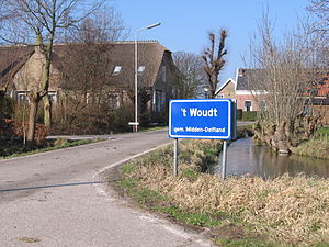
't Woudt
Place in South Holland, Netherlands
Distance: Approx. 3269 meters
Latitude and longitude: 51.99555556,4.29361111
't Woudt is a small village in the Dutch province of South Holland. It is located about 5 km southwest of the city of Delft, in the municipality of Midden-Delfland. 't Woudt (then spelled "'t Woud") was a separate municipality between 1812 and 1817, when it was divided into Groeneveld, Hoog en Woud Harnasch, and a part that merged with Hof van Delft.
Beresteinlaan RandstadRail station
Distance: Approx. 3247 meters
Latitude and longitude: 52.04222222,4.24944444
Beresteinlaan is a RandstadRail station in The Hague, Netherlands. It is a stop for line 4 and is located on the Meppelweg.

De Uithof RandstadRail station
Distance: Approx. 2995 meters
Latitude and longitude: 52.03944444,4.24527778
De Uithof is a RandstadRail station in The Hague, Netherlands. It is the final stop of line 4.
Westland (region), Netherlands
Distance: Approx. 2471 meters
Latitude and longitude: 52.00805556,4.22055556
Westland is a region of the Netherlands and lies in the western part of the Province of South Holland. It consists of the municipalities of Westland and Midden-Delfland, and also of the town of Hook of Holland (which is a part of the municipality of Rotterdam). Westland is well known for its horticulture in glasshouses, hence its nickname the glass city.

SV VELO
Dutch omnisports club
Distance: Approx. 2403 meters
Latitude and longitude: 52.03164167,4.27411111
SV VELO (short for Sportvereniging Verdedig en Loop Op) is an omnisports club from Wateringen, Netherlands. It has branches for handball, badminton, volleyball, football, checkers, boules, road cycling, and martial arts. The first squad football plays in the Eerste Klasse.
Weather in this IP's area
broken clouds
7 Celsius
3 Celsius
7 Celsius
8 Celsius
988 hPa
82 %
988 hPa
988 hPa
10000 meters
7.2 m/s
180 degree
80 %
