Country:
Region:
City:
Latitude and Longitude:
Time Zone:
Postal Code:
IP information under different IP Channel
ip-api
Country
Region
City
ASN
Time Zone
ISP
Blacklist
Proxy
Latitude
Longitude
Postal
Route
Luminati
Country
ASN
Time Zone
Europe/London
ISP
Daisy Corporate Services Trading Ltd
Latitude
Longitude
Postal
IPinfo
Country
Region
City
ASN
Time Zone
ISP
Blacklist
Proxy
Latitude
Longitude
Postal
Route
db-ip
Country
Region
City
ASN
Time Zone
ISP
Blacklist
Proxy
Latitude
Longitude
Postal
Route
ipdata
Country
Region
City
ASN
Time Zone
ISP
Blacklist
Proxy
Latitude
Longitude
Postal
Route
Popular places and events near this IP address

Darwen
Human settlement in England
Distance: Approx. 260 meters
Latitude and longitude: 53.698,-2.461
Darwen is a market town and civil parish in the Blackburn with Darwen borough in Lancashire, England. The residents of the town are known as "Darreners". The A666 road passes through Darwen towards Blackburn to the north, Bolton to the south and Pendlebury where it joins the A6, about 18 miles (29 km) north-west of Manchester.

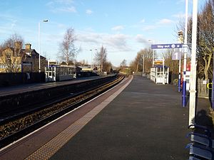
Darwen railway station
Railway station in Lancashire, England
Distance: Approx. 4 meters
Latitude and longitude: 53.698,-2.465
Darwen railway station serves Darwen, a town in Lancashire, England. It was opened in 1847 by the Bolton, Blackburn, Clitheroe & West Yorkshire Railway, which was subsequently taken over by the Lancashire and Yorkshire Railway twelve years later. It is now served by Northern Trains services on the Ribble Valley Line from Rochdale/Manchester Victoria to Blackburn and into Clitheroe.

Darwen Library
Distance: Approx. 161 meters
Latitude and longitude: 53.6967,-2.466
Darwen Library is a Carnegie library in Darwen, Lancashire, England. It opened in 1908 and is located on Knott Street.
Spring Vale railway station
Former railway station in England
Distance: Approx. 1347 meters
Latitude and longitude: 53.6868,-2.4572
Spring Vale railway station was a railway station that served the community of Spring Vale, in Darwen, Lancashire, England. It was opened by the Bolton, Blackburn, Clitheroe and West Yorkshire Railway on 3 August 1847, and was originally named Sough. At first, it was the southern terminus of the line from Blackburn (Bolton Road); the line south of Sough to Bolton opened on 12 June 1848 and was just located south of the road bridge at the top off Cranberry Lane The station was moved 150 yards north and was renamed Spring Vale and Sough in November 1870, and Spring Vale on 1 March 1877.
Marsh House, Darwen
Human settlement in England
Distance: Approx. 260 meters
Latitude and longitude: 53.698,-2.461
Marsh House is an area of Darwen, Lancashire, England.

Darwen Aldridge Community Academy
Academy in Darwen, Lancashire, England
Distance: Approx. 450 meters
Latitude and longitude: 53.694,-2.464
Darwen Aldridge Community Academy (DACA) is a secondary school and sixth form with academy status in the Blackburn with Darwen borough of Lancashire, England. It specialises in entrepreneurship and is part of the Aldridge Education Multi Academy Trust.

St Cuthbert's Church, Darwen
Church in Lancashire, England
Distance: Approx. 1181 meters
Latitude and longitude: 53.7052,-2.4781
St Cuthbert's Church is an Anglican church in the English market town of Darwen, Lancashire. It is an active parish church in the Diocese of Blackburn and the archdeaconry of Blackburn. The church was built 1875–1878 by Paley and Austin.

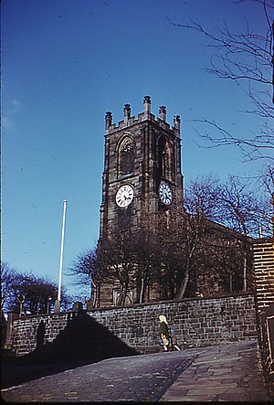
St Peter's Church, Darwen
Church in Lancashire, England
Distance: Approx. 280 meters
Latitude and longitude: 53.6955,-2.4645
St Peter's Church (formerly Holy Trinity Church) is in Bank Street, Darwen, Lancashire, England. It is an active Anglican parish church in the deanery of Blackburn with Darwen, the archdeaconry of Blackburn, and the diocese of Blackburn. The church is recorded in the National Heritage List for England as a designated Grade II* listed building.

St John the Evangelist's Church, Turncroft
Distance: Approx. 1023 meters
Latitude and longitude: 53.68986,-2.45774
St John the Evangelist's Church was an Anglican parish church in Turncroft, Over Darwen, Lancashire, England. It was paid for by a Mrs Graham, and designed by the Lancaster architect E. G. Paley. The church cost £8,000 (equivalent to £990,000 in 2023).
Barley Bank
Former cricket and football ground in Darwen, England
Distance: Approx. 982 meters
Latitude and longitude: 53.7019,-2.4783
Barley Bank was a cricket and football ground in Darwen in England. It was the home ground of Darwen F.C. during their time in the Football League.
Darwen Aldridge Enterprise Studio
Studio school in Darwen, Lancashire, England
Distance: Approx. 429 meters
Latitude and longitude: 53.6962,-2.4707
Darwen Aldridge Enterprise Studio (DAES) is a mixed studio school located in Lancashire, UK. It opened in September 2013. It is part of the Aldridge Education multi-academy trust. The school offers GCSEs and A Levels with a focus on creative digital, health and child-care and business-related subjects.

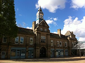
Darwen Town Hall
Municipal building in Darwen, Lancashire, England
Distance: Approx. 261 meters
Latitude and longitude: 53.696,-2.467
Darwen Town Hall is a municipal building in Croft Street, Darwen, Lancashire, England. It is the meeting place of Darwen Town Council.
Weather in this IP's area
scattered clouds
7 Celsius
7 Celsius
7 Celsius
8 Celsius
1025 hPa
83 %
1025 hPa
1004 hPa
10000 meters
1.34 m/s
2.68 m/s
97 degree
25 %
07:23:40
16:23:39