Country:
 Great Britain
Region:
City:
Latitude and Longitude:
Time Zone:
Postal Code:
IP information under different IP Channel
ip-api
Country
Region
City
ASN
Time Zone
ISP
Blacklist
Proxy
Latitude
Longitude
Postal
Route
IPinfo
Country
Region
City
ASN
Time Zone
ISP
Blacklist
Proxy
Latitude
Longitude
Postal
Route
MaxMind
Country
Region
City
ASN
Time Zone
ISP
Blacklist
Proxy
Latitude
Longitude
Postal
Route
Luminati
Country
GBASN
Time Zone
Europe/London
ISP
Daisy Corporate Services Trading Ltd
Latitude
Longitude
Postal
db-ip
Country
Region
City
ASN
Time Zone
ISP
Blacklist
Proxy
Latitude
Longitude
Postal
Route
ipdata
Country
Region
City
ASN
Time Zone
ISP
Blacklist
Proxy
Latitude
Longitude
Postal
Route
Popular places and events near this IP address

Birmingham Perry Barr (UK Parliament constituency)
Parliamentary constituency in the United Kingdom, 1950 onwards
Distance: Approx. 615 meters
Latitude and longitude: 52.52,-1.91
Birmingham Perry Barr is a constituency in the West Midlands, represented in the House of Commons of the UK Parliament by independent Ayoub Khan since July 2024. It had previously been held since 2001 by Khalid Mahmood of the Labour Party.
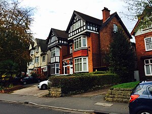
Handsworth Wood
Suburb of Birmingham in West Midlands, England
Distance: Approx. 771 meters
Latitude and longitude: 52.512,-1.918
Handsworth Wood is a suburb of Birmingham in the West Midlands County, England. Located within the metropolitan county of the West Midlands since 1 April 1974, under the Local Government Act 1972, it was historically a part of the county of Staffordshire. It is also a ward within the formal district of Perry Barr as well as other areas such as Great Barr, Sandwell and Hamstead/Hamstead Village.
Browns Green
Distance: Approx. 854 meters
Latitude and longitude: 52.5199,-1.9314
Browns Green (sometimes Brown's Green or historically Browne's Green) is a small area of Handsworth Wood, Birmingham, England. Adjacent areas include Handsworth, Hamstead and the hilltop area of Sandwell Valley.
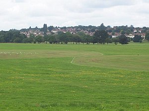
Perry Hall Park
Distance: Approx. 647 meters
Latitude and longitude: 52.52405,-1.91447
Perry Hall Park or Perry Hall Country Park, and previously Perry Hall Playing Fields, is a park in Perry Barr, Birmingham, England, at grid reference SP059918. It was in Staffordshire until 1928. The site is protected by Fields in Trust through a legal "Deed of Dedication" safeguarding the future of the space as public recreation land for future generations to enjoy.
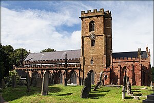
St Mary's Church, Handsworth
Church in England
Distance: Approx. 929 meters
Latitude and longitude: 52.51055556,-1.91916667
St Mary's Church, Handsworth, also known as Handsworth Old Church, is a Grade II* listed Anglican church in Handsworth, Birmingham, England. Its ten-acre (4 hectare) grounds are contiguous with Handsworth Park. It lies just off the Birmingham Outer Circle, and south of a cutting housing the site of the former Handsworth Wood railway station.
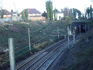
Handsworth Wood railway station
Former railway station in England
Distance: Approx. 788 meters
Latitude and longitude: 52.512,-1.9215
Handsworth Wood railway station was a railway station in Handsworth Wood, Birmingham, England, on the London and North Western Railway's rail link between the Chase Line and the West Coast Main Line. The station operated between 1896 and 1941, and like neighbouring station Soho Road, closed during the Second World War, as a result of decreasing use by passengers who possibly found the new 16 bus route more convenient. The station site lies in a cutting through Handsworth Park, adjacent to St.
King Edward VI Handsworth Wood Girls' Academy
Academy in Birmingham, West Midlands, England
Distance: Approx. 886 meters
Latitude and longitude: 52.514,-1.9292
King Edward VI Handsworth Wood Girls' Academy is a secondary school and sixth form located in Handsworth Wood, Birmingham, England. The building that the school currently occupies used to be known as Handsworth Wood Boys' School but it went through a change over ten years ago. The headteacher is Ms Kiran Takhar.
Birchfield Ladbroke Stadium
Former greyhound racing track in Birmingham
Distance: Approx. 959 meters
Latitude and longitude: 52.51803,-1.90481
The Birchfield Ladbroke Stadium, also known as the old Perry Barr Greyhound Stadium or Alexander Sports Stadium was a former greyhound racing and Motorcycle speedway stadium in Birchfield in the north of Birmingham, England. It is not to be confused with the current Perry Barr Stadium on the other side of the Walsall Road and accessed from Aldridge Road.
Wellington Road (Perry Barr)
Distance: Approx. 1109 meters
Latitude and longitude: 52.5149,-1.9039
Wellington Road was a football ground in the Perry Barr area of Birmingham, England. It was the home ground of Aston Villa from 1876 until 1897.

The Endwood
Public House (former residence) in Birmingham, England
Distance: Approx. 730 meters
Latitude and longitude: 52.512362,-1.919737
The Endwood is a disused grade II listed public house on Hamstead Road, in the Handsworth Wood district of Birmingham, England. The three-storey building was constructed as a private residence, Church Hill House, in 1820, when Handsworth Wood was part of Staffordshire. It has a stucco finish, a slate roof and porch with doric columns.

The Anchorage, Birmingham
House in Birmingham, England
Distance: Approx. 738 meters
Latitude and longitude: 52.5185,-1.92978
The Anchorage is a Grade II* listed building in Handsworth Wood, Birmingham, England. It was built in 1899, to Arts and Crafts-style designs by Joseph Crouch and Edmund Butler, as a house for Alfred Constantine, a manufacturing jeweller. At the time, the area was in Staffordshire.
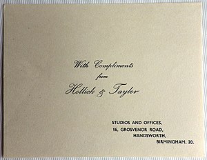
Grosvenor Road Studios
Distance: Approx. 742 meters
Latitude and longitude: 52.51361111,-1.91222222
Grosvenor Road Studios (GRS), formerly known as Hollick and Taylor Studios, is a suite of recording studios in Handsworth, Birmingham, England. It is the oldest extant recording studio in the city. The studios are in a former five-bedroomed house, 16 Grosvenor Road, which was built in 1872.
Weather in this IP's area
overcast clouds
12 Celsius
12 Celsius
12 Celsius
14 Celsius
1028 hPa
91 %
1028 hPa
1014 hPa
10000 meters
3.58 m/s
5.81 m/s
80 degree
100 %
06:49:06
19:13:44