Country:
 Great Britain
Region:
City:
Latitude and Longitude:
Time Zone:
Postal Code:
IP information under different IP Channel
ip-api
Country
Region
City
ASN
Time Zone
ISP
Blacklist
Proxy
Latitude
Longitude
Postal
Route
IPinfo
Country
Region
City
ASN
Time Zone
ISP
Blacklist
Proxy
Latitude
Longitude
Postal
Route
MaxMind
Country
Region
City
ASN
Time Zone
ISP
Blacklist
Proxy
Latitude
Longitude
Postal
Route
Luminati
Country
GBASN
Time Zone
Europe/London
ISP
CSC Computer Sciences Ltd
Latitude
Longitude
Postal
db-ip
Country
Region
City
ASN
Time Zone
ISP
Blacklist
Proxy
Latitude
Longitude
Postal
Route
ipdata
Country
Region
City
ASN
Time Zone
ISP
Blacklist
Proxy
Latitude
Longitude
Postal
Route
Popular places and events near this IP address

Tunbridge Wells Grammar School for Boys
Grammar school in Seal Hollow Rd, Sevenoaks, Kent
Distance: Approx. 1201 meters
Latitude and longitude: 51.15,0.26
Tunbridge Wells Grammar School for Boys (TWGSB) is a grammar school in Royal Tunbridge Wells, Kent, England. Founded as a technical school in 1956, TWGSB became a grammar school in 1982. The current enrolment of 1,984 pupils (of which 492 are in the sixth form) is spread across two sites: the main site in Tunbridge Wells and the annexe in Sevenoaks.

High Brooms railway station
Railway station in Kent, England
Distance: Approx. 435 meters
Latitude and longitude: 51.149,0.277
High Brooms railway station is on the Hastings line in the south of England and serves High Brooms and Southborough in the borough of Tunbridge Wells, Kent. It is 32 miles 70 chains (52.9 km) down the line from London Charing Cross. The station and all trains serving it are operated by Southeastern.

The Skinners' School
Grammar school in Royal Tunbridge Wells, Kent, England
Distance: Approx. 1588 meters
Latitude and longitude: 51.1425,0.261
The Skinners' School (formally The Skinners' Company's Middle School for Boys and commonly known as Skinners'), is a British Grammar School with academy status for boys located in the town of Royal Tunbridge Wells, Kent, England. Established in 1887, the school was founded by the Worshipful Company of Skinners (one of the 111 livery companies of the City of London) in response to a demand for education in the region. Today Skinners' remains an all-boys grammar school, recently awarded specialist status in science and mathematics in recognition of these disciplines' excellent teaching.
Tunbridge Wells Girls' Grammar School
Foundation grammar school in Tunbridge Wells, Kent, England
Distance: Approx. 1562 meters
Latitude and longitude: 51.1448,0.2583
Tunbridge Wells Girls' Grammar School (TWGGS), established in 1905, is an all-female selective school in Royal Tunbridge Wells, a town in Kent, England.

Southborough, Kent
Human settlement in England
Distance: Approx. 1105 meters
Latitude and longitude: 51.1598,0.2652
Southborough is a town and civil parish in the borough of Tunbridge Wells in Kent, England. It lies immediately to the north of the town of Tunbridge Wells and includes the district of High Brooms, with the A26 road passing through it. According to the 2001 census it had a population of 11,124.
St Gregory's Catholic School
Academy in Royal Tunbridge Wells, Kent, England
Distance: Approx. 1269 meters
Latitude and longitude: 51.15,0.259
St Gregory's Catholic School (often shortened to St Greg's) is an 11–18 mixed, Roman Catholic, secondary school and sixth form with academy status in Royal Tunbridge Wells, Kent, England. It was established in 1966 and is part of the Kent Catholic Schools' Partnership. It is located in the Roman Catholic Archdiocese of Southwark.
High Brooms
Human settlement in England
Distance: Approx. 400 meters
Latitude and longitude: 51.14932,0.27698
High Brooms is a suburb of Royal Tunbridge Wells in Kent, England. Its railway station is High Brooms railway station. It is connected by train to London and Hastings.
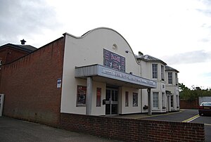
Royal Victoria Hall, Southborough
Distance: Approx. 1208 meters
Latitude and longitude: 51.156326,0.260151
Royal Victoria Hall, Kent was historically notable as the first Municipally funded theatre in England. It stood on London Road, Southborough, Kent and opened on 17 January 1900 to celebrate the Diamond Jubilee of Queen Victoria. A significant sum for the construction costs was raised by Sir David Lionel Goldsmid-Stern-Salomons, 2nd Baronet, who resided at nearby Broomhill.

Southborough Pit
Distance: Approx. 41 meters
Latitude and longitude: 51.153,0.276
Southborough Pit is a 1.1-hectare (2.7-acre) geological Site of Special Scientific Interest in Tunbridge Wells in Kent. It is a Geological Conservation Review site. This site dates to the Valanginian age, around 140 million years ago in the Lower Cretaceous.

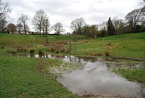
Barnett's Wood
Nature reserve in the United Kingdom
Distance: Approx. 576 meters
Latitude and longitude: 51.158,0.278
Barnett's Wood is a 12.4-hectare (31-acre) Local Nature Reserve in Southborough, on the northern outskirts of Tunbridge Wells in Kent. It is owned by Tunbridge Wells Borough Council and managed by Kent High Weald Project and the Friends of Barnett’s Wood. This site has ancient, semi-natural woodland and unimproved grassland.
Hilbert Woods
Park in Kent, United Kingdom
Distance: Approx. 1103 meters
Latitude and longitude: 51.143,0.276
Hilbert Woods is a 14.3-hectare (35-acre) Local Nature Reserve in Tunbridge Wells in Kent. It is owned by Tunbridge Wells Borough Council and managed by Kent High Weald Project and the Friends of Grosvenor and Hilbert Park. This gently sloping wood has oak, hazel and beech on the dry upper slopes, and alder on lower and wetter areas running down to a stream.
Tunbridge Wells power station
Historic power station
Distance: Approx. 1526 meters
Latitude and longitude: 51.14,0.26916667
Tunbridge Wells power station supplied electricity to the town of Royal Tunbridge Wells and the surrounding area from 1895 to 1968. The power station was built by the Tunbridge Wells Corporation which operated it until the nationalisation of the British electricity supply industry in 1948.
Weather in this IP's area
scattered clouds
13 Celsius
12 Celsius
12 Celsius
15 Celsius
1030 hPa
64 %
1030 hPa
1018 hPa
10000 meters
2.33 m/s
3.79 m/s
36 degree
44 %
06:36:08
19:11:22