217.28.99.23 - IP Lookup: Free IP Address Lookup, Postal Code Lookup, IP Location Lookup, IP ASN, Public IP
Country:
Region:
City:
Location:
Time Zone:
Postal Code:
ISP:
ASN:
language:
User-Agent:
Proxy IP:
Blacklist:
IP information under different IP Channel
ip-api
Country
Region
City
ASN
Time Zone
ISP
Blacklist
Proxy
Latitude
Longitude
Postal
Route
db-ip
Country
Region
City
ASN
Time Zone
ISP
Blacklist
Proxy
Latitude
Longitude
Postal
Route
IPinfo
Country
Region
City
ASN
Time Zone
ISP
Blacklist
Proxy
Latitude
Longitude
Postal
Route
IP2Location
217.28.99.23Country
Region
baden-wurttemberg
City
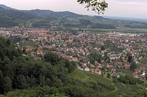
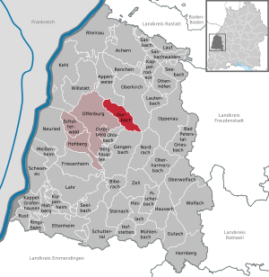
urloffen
Time Zone
Europe/Berlin
ISP
Language
User-Agent
Latitude
Longitude
Postal
ipdata
Country
Region
City
ASN
Time Zone
ISP
Blacklist
Proxy
Latitude
Longitude
Postal
Route
Popular places and events near this IP address

Renchen
City in Baden-Württemberg, Germany
Distance: Approx. 4082 meters
Latitude and longitude: 48.58583333,8.01055556
Renchen (Low Alemannic: Renche) is a small city in Baden-Württemberg, Germany, part of the district of Ortenau.

Appenweier
Municipality in Baden-Württemberg, Germany
Distance: Approx. 2595 meters
Latitude and longitude: 48.53972222,7.98
Appenweier (Low Alemannic: Appewiir) is a municipality in western Baden-Württemberg, Germany in the district of Ortenau.

Oberkirch (Baden)
City in Baden-Württemberg, Germany
Distance: Approx. 9023 meters
Latitude and longitude: 48.53333333,8.08333333
Oberkirch (Low Alemannic: Owerkirch) is a city in Western Baden-Württemberg, Germany about 12 km North-East of Offenburg and belongs to the Ortenaukreis district.

Durbach
Municipality in Baden-Württemberg, Germany
Distance: Approx. 7735 meters
Latitude and longitude: 48.5,8.01666667
Durbach is a municipality in the district of Ortenau in Baden-Württemberg in Germany. It is situated on the verge of the northern Black Forest Mountains six kilometers north east of the town of Offenburg. Main branches of commerce are agriculture (especially production of wine) and tourism.

Willstätt
Municipality in Baden-Württemberg, Germany
Distance: Approx. 5781 meters
Latitude and longitude: 48.54166667,7.89638889
Willstätt (German pronunciation: [ˈvɪlˌʃtɛt]) is a town in the district of Ortenau in Baden-Württemberg in Germany, with a population of 9,787 as at December 31, 2017. It is around 12 kilometres (7.5 mi) east of Strasbourg's city centre.

Önsbach
Borough of Achern in Baden-Württemberg, Germany
Distance: Approx. 6934 meters
Latitude and longitude: 48.6053,8.0361
Önsbach is the second-largest district ("Stadtteil") of the major district town ("Kreisstadt") of Achern in the north of Ortenaukreis, located in the Black Forest. Önsbach is located in northern Ortenau, south of the town of Achern. A third of the village lies in the Rhine valley and two thirds, in the western foothills of the Black Forest.
Schutter (Kinzig)
River in Germany
Distance: Approx. 8345 meters
Latitude and longitude: 48.5593,7.8555
The Schutter is a 57-kilometre-long (35 mi) river in Baden-Württemberg, Germany, and a left tributary of the Kinzig.
Offenburg station
Railway station in Offenburg, Germany
Distance: Approx. 9687 meters
Latitude and longitude: 48.47611111,7.94583333
Offenburg station (German: Bahnhof Offenburg) is a railway station in Baden-Württemberg and has seven tracks on four platforms. Offenburg used to be a railway town and the station was of major economic importance to it. In recent years the maintenance facilities and much of the rail freight yards have been closed.
Familienbrauerei Bauhöfer
Distance: Approx. 6209 meters
Latitude and longitude: 48.58037,8.04819
Familienbrauerei Bauhöfer GmbH & Co. KG ("Bauhöfer Family Brewery) is a brewery company in Renchen-Ulm, Baden-Württemberg, Germany, established in 1852. The company is a Gesellschaft mit beschränkter Haftung (GmbH, limited liability company) and a Kommanditgesellschaft (KG, limited partnership).

Schauenburg Castle (Oberkirch)
Ruined castle in Oberkirch, Germany
Distance: Approx. 9597 meters
Latitude and longitude: 48.5395,8.0945
Schauenburg Castle is a ruined hilltop castle located in Oberkirch, Germany, atop a 367-metre-high (1,204 ft) (NN) hill spur overlooking the Rench river valley above the town of Gaisbach, Baden-Württemberg. The castle was built by Duke Berthold II of Zähringen. The well-preserved ruin includes the remains of two towers with living quarters, a gate tower, a rampart, and a shield wall with an attached chapel.

Kork station
Railway station in Kehl, Germany
Distance: Approx. 6977 meters
Latitude and longitude: 48.57,7.87480556
Kork station (German: Bahnhof Kork (Kehl)) is a railway station in Kork, a suburb of Kehl, in southwestern Germany in the Ortenaukreis, Baden-Württemberg. It is on the Appenweier–Strasbourg railway, with trains crossing the Rhine into France to reach the latter destination. Both sides being within the Schengen Area, no passport or border controls apply.
Appenweier station
Railway station in Appenweier, Germany
Distance: Approx. 2298 meters
Latitude and longitude: 48.5414,7.9735
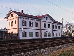
Appenweier station is a railway station in the municipality of Appenweier, located in the Ortenaukreis district in Baden-Württemberg, Germany. It sits at the eastern end of the Appenweier–Strasbourg railway, whose western end, at Strasbourg, is in France.
Weather in this IP's area
scattered clouds
9 Celsius
8 Celsius
8 Celsius
10 Celsius
1010 hPa
54 %
1010 hPa
985 hPa
10000 meters
3.11 m/s
6 m/s
181 degree
26 %


