Country:
 Canada
Region:
City:
Latitude and Longitude:
Time Zone:
Postal Code:
IP information under different IP Channel
ip-api
Country
Region
City
ASN
Time Zone
ISP
Blacklist
Proxy
Latitude
Longitude
Postal
Route
IPinfo
Country
Region
City
ASN
Time Zone
ISP
Blacklist
Proxy
Latitude
Longitude
Postal
Route
MaxMind
Country
Region
City
ASN
Time Zone
ISP
Blacklist
Proxy
Latitude
Longitude
Postal
Route
Luminati
Country
CARegion
qc
City
gatineau
ASN
Time Zone
America/Toronto
ISP
OXIO-ASN-01
Latitude
Longitude
Postal
db-ip
Country
Region
City
ASN
Time Zone
ISP
Blacklist
Proxy
Latitude
Longitude
Postal
Route
ipdata
Country
Region
City
ASN
Time Zone
ISP
Blacklist
Proxy
Latitude
Longitude
Postal
Route
Popular places and events near this IP address
Rockland, Ontario
Community in Ontario, Canada
Distance: Approx. 6924 meters
Latitude and longitude: 45.55,-75.28333333
Rockland is a bilingual community located about 40 km (25 mi) east of downtown Ottawa, Ontario, Canada, part of the city of Clarence-Rockland. Rockland has a population of 26,505 (2021). It is home to a large part of the francophone community in Eastern Ontario along with the towns situated to the east and the Ottawa suburb of Orleans to the west.
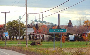
Thurso, Quebec
City in Quebec, Canada
Distance: Approx. 1289 meters
Latitude and longitude: 45.59694444,-75.24333333
Thurso is a city in Papineau Regional County Municipality in the Outaouais region of western Quebec, Canada. It is located opposite Clarence, Ontario on the Ottawa River, and is within Canada's National Capital Region. Its population was 3,084 as of the 2021 Canadian Census.

Lochaber, Quebec
Township municipality in Quebec, Canada
Distance: Approx. 3855 meters
Latitude and longitude: 45.63333333,-75.21666667
Lochaber is a township municipality in the Canadian province of Quebec, located within the Papineau Regional County Municipality. The township had a population of 415 in the 2016 Canadian Census.
Lochaber-Partie-Ouest, Quebec
Township municipality in Quebec, Canada
Distance: Approx. 4037 meters
Latitude and longitude: 45.61666667,-75.3
Lochaber-Partie-Ouest is a township municipality in the Canadian province of Quebec, located within the Papineau Regional County Municipality. The township had a population of 926 in the 2021 Canadian Census. The township is predominantly agricultural which is the main economic activity.

Plaisance National Park
National park of Quebec, Canada
Distance: Approx. 9112 meters
Latitude and longitude: 45.6,-75.1333
Plaisance National Park is a provincial park located near Plaisance in the province of Quebec, Canada. The park was established on March 22, 2002 and covers an area of 28.3 square kilometres (10.9 sq mi).
Rockland District High School
Middle school and secondary school in Clarence-Rockland, Ontario, Canada
Distance: Approx. 7557 meters
Latitude and longitude: 45.54431,-75.284866
Rockland District High School (other common names are RDHS and RD) is a public intermediate and secondary school in Clarence-Rockland, Ontario, Canada. It is part of the Upper Canada District School Board. The school has offered secondary grades 9-12 since opening, and added intermediate grades 7–8 in the 2012–2013 school year.

CHRC-FM
Radio station in Clarence-Rockland, Ontario, Canada
Distance: Approx. 9844 meters
Latitude and longitude: 45.52416667,-75.29166667
CHRC-FM (92.5 MHz) is a commercial radio station licensed to Rockland, Ontario, Canada. The station is owned by Evanov Communications through licensee Dufferin Communications Inc. It broadcasts a country format and is branded as Hot Country 92.5.
École secondaire catholique L'Escale
Distance: Approx. 7083 meters
Latitude and longitude: 45.5493,-75.2862
L'École secondaire catholique l'Escale is a French-Language Catholic high school located in Rockland, Ontario. It is managed by the Conseil scolaire de district catholique de l'Est ontarien.
Weather in this IP's area
overcast clouds
20 Celsius
20 Celsius
17 Celsius
21 Celsius
1018 hPa
84 %
1018 hPa
1009 hPa
10000 meters
1.1 m/s
1.07 m/s
1 degree
100 %
06:43:39
19:06:25