Country:
 Canada
Region:
City:
Latitude and Longitude:
Time Zone:
Postal Code:
IP information under different IP Channel
ip-api
Country
Region
City
ASN
Time Zone
ISP
Blacklist
Proxy
Latitude
Longitude
Postal
Route
IPinfo
Country
Region
City
ASN
Time Zone
ISP
Blacklist
Proxy
Latitude
Longitude
Postal
Route
MaxMind
Country
Region
City
ASN
Time Zone
ISP
Blacklist
Proxy
Latitude
Longitude
Postal
Route
Luminati
Country
CARegion
qc
City
gatineau
ASN
Time Zone
America/Toronto
ISP
OXIO-ASN-01
Latitude
Longitude
Postal
db-ip
Country
Region
City
ASN
Time Zone
ISP
Blacklist
Proxy
Latitude
Longitude
Postal
Route
ipdata
Country
Region
City
ASN
Time Zone
ISP
Blacklist
Proxy
Latitude
Longitude
Postal
Route
Popular places and events near this IP address
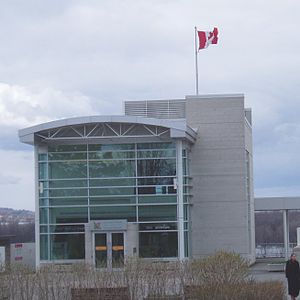
Centre for Geography and Exploration
Distance: Approx. 1173 meters
Latitude and longitude: 45.442168,-75.695679
The Centre for Geography and Exploration, located at 50 Sussex Drive in Ottawa, is headquarters to the Royal Canadian Geographical Society (RCGS) and home to Canadian Geographic magazine, as well as Can Geo Education and special project departments. The Canada and the World Pavilion was a small museum in Ottawa, Ontario, Canada. Exhibits were devoted to Canada's contribution to sport, arts and culture, development, peacekeeping, and science.

Lester B. Pearson Building
Office building in Ottawa, Canada
Distance: Approx. 1288 meters
Latitude and longitude: 45.43698056,-75.69605278
The Lester B. Pearson Building is an office building in Ottawa, Ontario, Canada. It is located at 125 Sussex Drive in the Lower Town neighbourhood and currently serves as the headquarters of Global Affairs Canada. It was officially opened on 1 August 1973 by Queen Elizabeth II. It is named after Lester B. Pearson, former Prime Minister of Canada and external affairs minister which has earned it the nickname "Fort Pearson".

Green Island (Rideau River)
Distance: Approx. 1273 meters
Latitude and longitude: 45.439922,-75.69476
Green Island in Ottawa, Ontario, Canada, is an island at the junction of the Rideau River, just off Sussex Drive in Ottawa at the Rideau Falls at the confluence with the Ottawa River. It is situated near the neighbourhood of New Edinburgh. To the west of the island is the National Research Council, and Global Affairs Canada (formerly Foreign Affairs, Trade and Development Canada); to the east is 24 Sussex Drive and the embassy of France.

John G. Diefenbaker Building
Office building in Ottawa, Canada
Distance: Approx. 1281 meters
Latitude and longitude: 45.43991111,-75.69466111
The John G. Diefenbaker Building is a building in the New Edinburgh neighbourhood of Ottawa, Ontario. The building served as Ottawa's city hall from August 2, 1958, to January 1, 2001, and afterward was commonly known as Old City Hall. Purchased in 2003 by the Government of Canada, it was known by its municipal address, 111 Sussex Drive, until September 2011 when it was renamed after Canada's 13th prime minister, John Diefenbaker.
Ottawa Memorial
Distance: Approx. 1153 meters
Latitude and longitude: 45.44085556,-75.69608333
The Ottawa Memorial is a monument in Ottawa, Ontario, that "commemorates by name almost 800 men and women who lost their lives while serving or training with the Air Forces of the Commonwealth in Canada, the West Indies and the United States and who have no known grave. " Located on Sussex Drive overlooking the Ottawa River near the Rideau Falls, the monument was unveiled in 1959 by Elizabeth II, Queen of Canada. It is maintained by the Commonwealth War Graves Commission.

Rideau Falls
Waterfalls in Ottawa, Canada
Distance: Approx. 1135 meters
Latitude and longitude: 45.441405,-75.69623
The Rideau Falls (French: Chutes de la rivière Rideau) are two 11-metre (36 ft.) waterfalls located in Ottawa, Ontario, Canada, where the Rideau River empties into the Ottawa River. The falls are divided by Green Island, with Ottawa's Old City Hall just to the south. To the west of the falls is the headquarters of the National Research Council while to the east are the Canada and the World Pavilion and the French Embassy.

Embassy of France, Ottawa
Diplomatic mission
Distance: Approx. 1272 meters
Latitude and longitude: 45.443356,-75.694481
The Embassy of France in Ottawa is the diplomatic mission of France to Canada, located at 42 Sussex Drive in the New Edinburgh neighbourhood of Ottawa.

Monument to Canadian Aid Workers
Distance: Approx. 1230 meters
Latitude and longitude: 45.442384,-75.694948
The Monument to Canadian Aid Workers (French: Monument commémoratif de l'aide humanitaire canadienne) is a monument in Ottawa, Ontario, Canada. It is dedicated to Canadian aid workers who have lost their lives during foreign deployments. As a monument, it is internationally unique in its form and purpose.

Macdonald-Cartier Bridge
Canadian bridge connecting Ottawa to Gatineau crossing the Ottawa River
Distance: Approx. 896 meters
Latitude and longitude: 45.43666667,-75.7025
The Macdonald-Cartier Bridge (French: Pont Macdonald-Cartier) is a bridge connecting Ottawa, Ontario, to Gatineau, Quebec. The bridge is a 618 m (2,028 ft) long continuous steel box girder bridge and carries six lanes of traffic. It links King Edward Avenue and Sussex Drive in Ottawa with Autoroute 5 in Quebec.

Earnscliffe
Canadian diplomatic residence
Distance: Approx. 1071 meters
Latitude and longitude: 45.437378,-75.698912
Earnscliffe is a Victorian manor in Ottawa, Ontario, built in the Gothic Revival style. During the late 19th century, it was home to Canada's first Prime Minister, Sir John A. Macdonald. Since 1930, it has served as the residence of the British High Commissioner to Canada.
Jacques-Cartier Park
Distance: Approx. 491 meters
Latitude and longitude: 45.438318,-75.707989
Jacques-Cartier Park is a park in Gatineau, Quebec, Canada, along the Ottawa River. The park is more than 22.68 hectares large and is located at the base of the Alexandra Bridge, facing the National Gallery of Canada in Ottawa. It is named for French explorer Jacques Cartier, who arrived at the mouth of the Ottawa River while he was looking for the Northwest Passage.
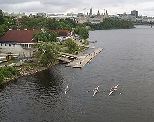
Ottawa Rowing Club
Canadian rowing club
Distance: Approx. 1146 meters
Latitude and longitude: 45.43530278,-75.69993611
The Ottawa Rowing Club (ORC) is a rowing club based in the city of Ottawa, Ontario. It is the oldest continuous rowing club in Canada. It is a registered club with Rowing Canada and Row Ontario.
Weather in this IP's area
broken clouds
20 Celsius
20 Celsius
18 Celsius
21 Celsius
1017 hPa
85 %
1017 hPa
1011 hPa
10000 meters
75 %
06:45:33
19:08:12