Country:
 Canada
Region:
City:
Latitude and Longitude:
Time Zone:
Postal Code:
IP information under different IP Channel
ip-api
Country
Region
City
ASN
Time Zone
ISP
Blacklist
Proxy
Latitude
Longitude
Postal
Route
IPinfo
Country
Region
City
ASN
Time Zone
ISP
Blacklist
Proxy
Latitude
Longitude
Postal
Route
MaxMind
Country
Region
City
ASN
Time Zone
ISP
Blacklist
Proxy
Latitude
Longitude
Postal
Route
Luminati
Country
CARegion
qc
City
longueuil
ASN
Time Zone
America/Toronto
ISP
OXIO-ASN-01
Latitude
Longitude
Postal
db-ip
Country
Region
City
ASN
Time Zone
ISP
Blacklist
Proxy
Latitude
Longitude
Postal
Route
ipdata
Country
Region
City
ASN
Time Zone
ISP
Blacklist
Proxy
Latitude
Longitude
Postal
Route
Popular places and events near this IP address

Chambly, Quebec
City in Quebec, Canada
Distance: Approx. 2258 meters
Latitude and longitude: 45.45,-73.28333333
Chambly is an off-island suburb of Montreal in southwestern Quebec, Canada. It is located in the Montérégie region, inland from the South Shore of the Saint Lawrence River. It was formed from the merger in 1965 of Fort-Chambly (formerly Chambly-Canton prior to 1952) and the old city of Chambly (formerly Chambly-Basin prior to 1952, and earlier sometimes called Bassin-de-Chambly).
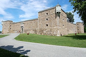
Fort Chambly
Historic fort in Quebec, Canada
Distance: Approx. 2136 meters
Latitude and longitude: 45.44944444,-73.27694444
Fort Chambly is a historic fort in La Vallée-du-Richelieu Regional County Municipality, Quebec. It is designated as a National Historic Site of Canada. Fort Chambly was formerly known as Fort St.
Carignan/Rivère l'Acadie Water Aerodrome
Airport in Carignan, Quebec
Distance: Approx. 2059 meters
Latitude and longitude: 45.47388889,-73.295
Carignan/Rivère l'Acadie Water Aerodrome (TC LID: CJF2) is an aerodrome located near Carignan, Quebec, Canada.
Chambly (provincial electoral district)
Provincial electoral district in the Montérégie region of Quebec, Canada
Distance: Approx. 1627 meters
Latitude and longitude: 45.454,-73.264
Chambly is a provincial electoral district in the Montérégie region of Quebec, Canada. It includes the city of Chambly and other smaller municipalities. It was created for the 1867 election (and an electoral district of that name existed earlier in the Legislative Assembly of the Province of Canada and the Legislative Assembly of Lower Canada).

Saint-Mathias-sur-Richelieu
Municipality in Quebec, Canada
Distance: Approx. 300 meters
Latitude and longitude: 45.46666667,-73.26666667
Saint-Mathias-sur-Richelieu is a municipality in the Canadian province of Quebec. It is located within the Rouville Regional County Municipality in the Montérégie region on the Richelieu River. The population as of the Canada 2021 Census was 4,544.

Chambly Basin
Body of water in Montérégie, Quebec
Distance: Approx. 1293 meters
Latitude and longitude: 45.46111111,-73.28333333
The Chambly Basin (French: bassin de Chambly) is a shallow, oblong body of water formed by an enlargement of the Richelieu River, extending out from the foot of the rapids on the river between Chambly and Richelieu, in the Quebec region of Montérégie. The towns of Chambly, Richelieu, Saint-Mathias-sur-Richelieu and Carignan surround the basin. The Chambly Basin is an important area for recreational tourism activities including boating in the summer, the connected Chambly Canal and nearby Fort Chambly National Historic Sites.
Acadia River
River in Canada
Distance: Approx. 1739 meters
Latitude and longitude: 45.48361,-73.26917
The Acadia River flows Northerly over 82 km through seven municipalities in the MRC La Vallée-du-Richelieu, Les Jardins-de-Napierville and Le Haut-Richelieu, in Montérégie, on the South Shore of St. Lawrence river, the Quebec, Canada. The Acadia river empties into the Richelieu River, in Carignan, skirting the city of Chambly by the north.
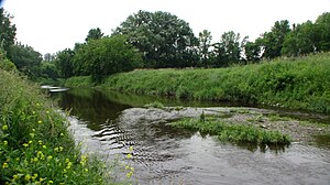
Rivière des Hurons (Richelieu River tributary)
River in Quebec, Canada
Distance: Approx. 1104 meters
Latitude and longitude: 45.45972,-73.26222
The rivière des Hurons (English: Hurons River) flows for 33 kilometres (21 mi) to the east side spill in the Chambly Basin just north of the city of Chambly. Its mouth is in the municipality of Saint-Mathias-sur-Richelieu in the Rouville Regional County Municipality, in the administrative region of Montérégie, in Quebec, in Canada. Hurons River flows through the Les Maskoutains Regional County Municipality, RCM of La Vallée-du-Richelieu Regional County Municipality, then the western part of the MRC Rouville Regional County Municipality.

St. Stephen's Anglican Church
Anglican church in Quebec, Canada
Distance: Approx. 2264 meters
Latitude and longitude: 45.44784,-73.27383
St. Stephen's Anglican Church is a church in Chambly, Quebec affiliated with the Anglican Church of Canada. It was built in 1820 to serve the garrison of Fort Chambly as well as the Loyalist and English settler population in and around Chambly.
Île aux Lièvres (Richelieu River)
Distance: Approx. 1824 meters
Latitude and longitude: 45.47166,-73.29278
L île aux Lièvres (English: Hare Island) is a river island of the Richelieu River, in the territory of the municipality of Carignan, in the La Vallée-du-Richelieu Regional County Municipality, in the region administrative Montérégie, in the south of province of Quebec, in Canada. This island includes the municipal park of the northern tip of Île aux Lièvres, the Seigneurie park and the Chenaux park.
Demers Island
River island in Quebec, Canada
Distance: Approx. 1399 meters
Latitude and longitude: 45.46528,-73.2875
The Demers Island is a river island of the Richelieu River. It is located in the territory of the municipality of Carignan, in the La Vallée-du-Richelieu Regional County Municipality, in the administrative region of Montérégie, in the south of province of Quebec, in Canada. This island has a few private wharves on the west shore of the Chambly basin.
Goyer Island
Distance: Approx. 1265 meters
Latitude and longitude: 45.47694,-73.28
L'Île Goyer is a river island of the Richelieu River. It belongs to the territory of the municipality of Carignan, in the La Vallée-du-Richelieu Regional County Municipality, in the administrative region of Montérégie, in the south of province of Quebec, in Canada. A municipal Bévédère stop, located on backfilled land, is located on the southeast side on the shore of the Bassin-de-Chambly, where civic parties are sometimes organized.
Weather in this IP's area
clear sky
20 Celsius
20 Celsius
18 Celsius
21 Celsius
1017 hPa
78 %
1017 hPa
1016 hPa
10000 meters
06:35:46
18:58:28