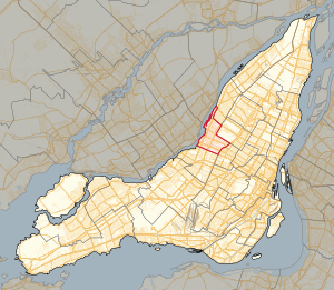
Country:
 Canada
Region:
City:
Latitude and Longitude:
Time Zone:
Postal Code:
IP information under different IP Channel
ip-api
Country
Region
City
ASN
Time Zone
ISP
Blacklist
Proxy
Latitude
Longitude
Postal
Route
IPinfo
Country
Region
City
ASN
Time Zone
ISP
Blacklist
Proxy
Latitude
Longitude
Postal
Route
MaxMind
Country
Region
City
ASN
Time Zone
ISP
Blacklist
Proxy
Latitude
Longitude
Postal
Route
Luminati
Country
CARegion
qc
City
montreal
ASN
Time Zone
America/Toronto
ISP
OXIO-ASN-01
Latitude
Longitude
Postal
db-ip
Country
Region
City
ASN
Time Zone
ISP
Blacklist
Proxy
Latitude
Longitude
Postal
Route
ipdata
Country
Region
City
ASN
Time Zone
ISP
Blacklist
Proxy
Latitude
Longitude
Postal
Route
Popular places and events near this IP address

Crémazie station
Montreal Metro station
Distance: Approx. 818 meters
Latitude and longitude: 45.54611111,-73.63833333
Crémazie station is a Montreal Metro station in Montreal, Quebec, Canada. It is operated by the Société de transport de Montréal (STM) and serves the Orange Line. It is located on the border between the boroughs of Ahuntsic-Cartierville and Villeray–Saint-Michel–Parc-Extension The station opened October 14, 1966, as part of the original Metro network.

Jarry station
Montreal Metro station
Distance: Approx. 1446 meters
Latitude and longitude: 45.54333333,-73.62861111
Jarry station is a Montreal Metro station in the borough of Villeray–Saint-Michel–Parc-Extension in Montreal, Quebec, Canada. It is operated by the Société de transport de Montréal (STM) and serves the Orange Line. The station opened on October 14, 1966, as part of the original network of the Metro.

Complexe sportif Claude-Robillard
Sports facility in Quebec, Canada
Distance: Approx. 315 meters
Latitude and longitude: 45.55411944,-73.63663056
The Complexe sportif Claude-Robillard (French: [kɔ̃plɛks spɔʁtif klod ʁobijɑʁ]), abbreviated CSCR, is a multi-purpose sport facility, located in Montreal, Quebec, Canada, in the borough of Ahuntsic-Cartierville.

Hochelaga Archipelago
Group of islands at the confluence of the Saint Lawrence and Ottawa Rivers
Distance: Approx. 894 meters
Latitude and longitude: 45.54944444,-73.65055556
The Hochelaga Archipelago (French: Archipel d'Hochelaga), also known as the Montreal Islands, is a group of islands at the confluence of the Saint Lawrence and Ottawa rivers in the southwestern part of the province of Quebec, Canada.
Collège Ahuntsic
Public college in Montréal, Quebec
Distance: Approx. 250 meters
Latitude and longitude: 45.55194444,-73.64305556
Collège Ahuntsic is a French-language public college situated in the Ahuntsic-Cartierville borough of Montreal, Quebec, Canada. It was founded in 1967 as a merger of the Collège Saint-Ignace and the Institut de technologies Laval, and in 1970 the Institut des arts graphiques du Quebec joined the college.
Maurice-Richard
Provincial electoral district in Quebec, Canada
Distance: Approx. 1345 meters
Latitude and longitude: 45.548,-73.656
Maurice-Richard is a provincial electoral district in the Montreal region of Quebec, Canada that elects members to the National Assembly of Quebec. It comprises parts of the Ahuntsic-Cartierville and Montréal-Nord boroughs of the city of Montreal. The riding was known from 1972 to 2018 as Crémazie.

Ahuntsic station (Via Rail)
Railway station in Montreal, Quebec, Canada
Distance: Approx. 912 meters
Latitude and longitude: 45.5531,-73.6522
Ahuntsic station is a former intercity railway station in the Ahuntsic-Cartierville borough of Montreal, Quebec, Canada. It was an unstaffed shelter that served as an optional stop for two Via Rail routes running from Montreal. It was located on Durham Avenue, near the Sauvé metro station; the RTM Mascouche commuter rail line stops at the Sauvé station nearby.
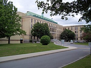
Collège André-Grasset
Private college in Montreal, Canada
Distance: Approx. 675 meters
Latitude and longitude: 45.55055556,-73.63277778
Collège André-Grasset is a private college in Montreal, Quebec, Canada. It is located near the Quebec Autoroute 40 and the Crémazie metro station. The college was founded in 1927 by the priests of Saint-Sulpice Seminary (Montreal) and named after priest and martyr André Grasset.The school was built at the request of the Archbishop of Montreal.
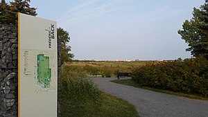
Frédéric-Back Park
Urban park in Montreal, Canada
Distance: Approx. 1434 meters
Latitude and longitude: 45.5633,-73.6289
Frédéric-Back Park (French: Parc Frédéric-Back) is an urban park in Montreal, Quebec, Canada. It is within the Saint-Michel environmental complex in the borough of Villeray–Saint-Michel–Parc-Extension. The 192-hectare area originally was a limestone quarry, then a landfill.

Sauvé station
Montreal Metro station
Distance: Approx. 1248 meters
Latitude and longitude: 45.55083333,-73.65611111
Sauvé station is an intermodal transit station in the borough of Ahuntsic-Cartierville in Montreal, Quebec, Canada. The Montreal Metro station is operated by the Société de transport de Montréal (STM) and serves the Orange Line. It is located in the Ahuntsic district.
Saint-Michel environmental complex
Multi-functional park in Montreal
Distance: Approx. 1434 meters
Latitude and longitude: 45.5633,-73.6289
The Saint-Michel environmental complex is a large multi-functional park in Montreal, Quebec, Canada. It is located in borough of Villeray–Saint-Michel–Parc-Extension on the site of a former limestone quarry, the Miron Quarry. Its current area is 192 hectares (470 acres), and has 5.5 kilometres (3.4 miles) of pathways.

CESM Soccer Center
Facility in Montreal, Quebec, Canada
Distance: Approx. 1011 meters
Latitude and longitude: 45.56222222,-73.63805556
Situated in the city of Montreal, Quebec, Canada, the CESM Soccer Center is a dedicated enclosed facility primarily designed for soccer activities which officially opened in 2015. Designed by Saucier+Perrotte Architectes in collaboration with HCMA Architecture+Design, the center offers expansive indoor spaces accommodating multiple soccer fields on an annual basis. Additionally, the project encompasses an outdoor soccer area for use during favorable weather conditions.
Weather in this IP's area
clear sky
20 Celsius
20 Celsius
17 Celsius
21 Celsius
1017 hPa
78 %
1017 hPa
1013 hPa
10000 meters
06:37:14
18:59:58