Country:
Region:
City:
Latitude and Longitude:
Time Zone:
Postal Code:
IP information under different IP Channel
ip-api
Country
Region
City
ASN
Time Zone
ISP
Blacklist
Proxy
Latitude
Longitude
Postal
Route
Luminati
Country
ASN
Time Zone
Europe/Amsterdam
ISP
CITIC Telecom CPC Netherlands B.V.
Latitude
Longitude
Postal
IPinfo
Country
Region
City
ASN
Time Zone
ISP
Blacklist
Proxy
Latitude
Longitude
Postal
Route
db-ip
Country
Region
City
ASN
Time Zone
ISP
Blacklist
Proxy
Latitude
Longitude
Postal
Route
ipdata
Country
Region
City
ASN
Time Zone
ISP
Blacklist
Proxy
Latitude
Longitude
Postal
Route
Popular places and events near this IP address

Riga International Airport
Airport in Latvia
Distance: Approx. 167 meters
Latitude and longitude: 56.92361111,23.97111111
RIX Riga Airport (Latvian: RIX Rīgas lidosta; IATA: RIX, ICAO: EVRA) is the international airport of Riga, the capital of Latvia, and the largest airport in the Baltic states with direct flights to 107 destinations as of September 2024. It serves as a hub for airBaltic, SmartLynx Airlines and RAF-Avia, and as one of the base airports for Ryanair. The Latvian national carrier airBaltic is the largest carrier that serves the airport, followed by Ryanair.

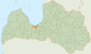
Imanta
Neighbourhood of Riga, Latvia
Distance: Approx. 3445 meters
Latitude and longitude: 56.95,24
Imanta is a neighbourhood on the western edge of Riga, Latvia. The neighbourhood's northern border is Kurzeme Prospekts (Boulevard); and in the south, Imanta is separated from the newer Zolitūde neighbourhood by the Riga—Jūrmala railroad. Prior to development, the region consisted largely of pine forests, sections of which have been preserved in Anninmuiza Park in the center of Imanta, and the Kleistu forest to its north.
Zolitūde
Neighborhood of Riga, Latvia
Distance: Approx. 3538 meters
Latitude and longitude: 56.94694444,24.01097222
Zolitūde (Latvian pronunciation: [ˈzɔlituːde]) is mainly an apartment house neighbourhood (or microdistrict) located in the western part of Riga, the capital of Latvia. Zolitūde is a centrally planned estate, consisting mostly of prefabricated concrete block Brutalist style homes built in late Soviet times. Construction started in 1984, and was mostly halted in 1991, when Latvia obtained its independence from the USSR. Large parts of the population, as in similar neighbourhoods of Riga, are Russian speaking.

Ziepniekkalns
Neighborhood of Riga, Latvia
Distance: Approx. 3445 meters
Latitude and longitude: 56.95,24
Ziepniekkalns is a neighborhood of Riga, Latvia. It is located in the Pārdaugava section of Riga close to the city's southern border. Ziepniekkalns is the latest out of all Riga's neighborhoods.

Beberbeķi
Neighbourhood of Riga, Latvia
Distance: Approx. 3352 meters
Latitude and longitude: 56.95,23.95
Beberbeķi is a neighbourhood consisting mainly of private houses which lies on the western edge of Riga, Latvia. The swampy forest in Mūķupurvs and the Rīga International Airport noise area divides it from the rest of the city. Within the neighborhood is Beberbeķi Park, which contains a small lake used as a beach and ice fishing.

Pleskodāle
Neighbourhood of Riga
Distance: Approx. 3985 meters
Latitude and longitude: 56.9325,24.0364
Pleskodāle is a neighbourhood of Riga consisting mostly of private houses on the western side of the city. It borders the Zolitūde and Šampēteris neighbourhoods.

Riga Aviation Museum
Museum in Riga, Latvia
Distance: Approx. 928 meters
Latitude and longitude: 56.91888889,23.95972222
Riga Aviation Museum is an aviation museum in Riga, Latvia.

Babīte Municipality
Municipality of Latvia
Distance: Approx. 3352 meters
Latitude and longitude: 56.95,23.95
Babīte Municipality (Latvian: Babītes novads) is a former municipality in Latvia. The municipality was formed in 2009 when Babīte parish and Sala parish merged with the administrative centre becoming Piņķi.

Mūkupurvs
Neighbourhood of Riga, Latvia
Distance: Approx. 1795 meters
Latitude and longitude: 56.9383,23.9808
Mūkupurvs is a neighborhood of the city of Riga, the capital city of Latvia and in Pārdaugava, a suburb of Zemgale. Mūkupurva neighborhood is located in the R part of Riga. It borders Beberbekai, Zolitūde and Pleskodāle neighborhoods, as well as Mārupe parish of Mārupe county, which is adjacent to the D part of Mūkupurva neighborhood.

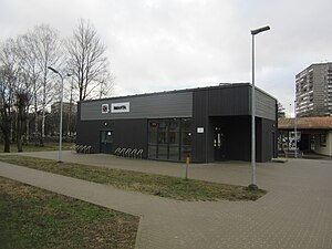
Imanta Station
Railway station in Latvia
Distance: Approx. 3472 meters
Latitude and longitude: 56.95074722,23.99832222
Imanta Station is a railway station on the Torņakalns – Tukums II Railway. It's located near and named after the Imanta neighborhood of the Kurzeme District of Riga, Latvia. All electric trains of the line stop at the station.
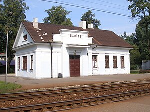
Babīte Station
Railway station in Latvia
Distance: Approx. 4045 meters
Latitude and longitude: 56.95727778,23.95283056
Babīte Station is a railway station on the Torņakalns – Tukums II Railway.

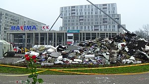
Zolitūde shopping centre roof collapse
2013 disaster in Riga, Latvia
Distance: Approx. 3574 meters
Latitude and longitude: 56.94388889,24.0175
On 21 November 2013 the roof of a Maxima shopping centre in the Zolitūde neighbourhood of Riga, Latvia, collapsed at 17:44 local time resulting in the deaths of 54 people, including three rescue workers, and injuries to another 41 people. An unknown number of people were able to leave the store on their own after the initial collapse. It was the worst disaster in Latvia since 1950, when the steamer Mayakovsky sank in Riga, killing 147 people.
Weather in this IP's area
scattered clouds
5 Celsius
5 Celsius
5 Celsius
5 Celsius
1012 hPa
93 %
1012 hPa
1011 hPa
10000 meters
1.03 m/s
40 %
08:03:31
16:13:52

