Country:
Region:
City:
Latitude and Longitude:
Time Zone:
Postal Code:
IP information under different IP Channel
ip-api
Country
Region
City
ASN
Time Zone
ISP
Blacklist
Proxy
Latitude
Longitude
Postal
Route
Luminati
Country
ASN
Time Zone
Europe/London
ISP
Linix Ltd
Latitude
Longitude
Postal
IPinfo
Country
Region
City
ASN
Time Zone
ISP
Blacklist
Proxy
Latitude
Longitude
Postal
Route
db-ip
Country
Region
City
ASN
Time Zone
ISP
Blacklist
Proxy
Latitude
Longitude
Postal
Route
ipdata
Country
Region
City
ASN
Time Zone
ISP
Blacklist
Proxy
Latitude
Longitude
Postal
Route
Popular places and events near this IP address

Manchester city centre
Central business district in Manchester, Greater Manchester, England
Distance: Approx. 9 meters
Latitude and longitude: 53.48083333,-2.2425
Manchester City Centre is the central business district of Manchester, in Greater Manchester, England, within the confines of Great Ancoats Street, A6042 Trinity Way, and A57(M) Mancunian Way, which collectively form an inner ring road. The City Centre ward had a population of 17,861 at the 2011 census. Manchester city centre evolved from the civilian vicus of the Roman fort of Mamucium, on a sandstone bluff near the confluence of the rivers Medlock and Irwell.

100 King Street
Building in Manchester, England
Distance: Approx. 38 meters
Latitude and longitude: 53.48055556,-2.24222222
100 King Street, formerly the Midland Bank, is a former bank premises on King Street in Manchester, England. It was designed by Sir Edwin Lutyens in 1928 and constructed in 1933–35. It is Lutyens' major work in Manchester and was designated a Grade II* listed building in 1974.

Cross Street Chapel
Unitarian church in Manchester, England
Distance: Approx. 154 meters
Latitude and longitude: 53.4817,-2.2444
Cross Street Chapel is a Unitarian church in central Manchester, England. It is a member of the General Assembly of Unitarian and Free Christian Churches, the umbrella organisation for British Unitarians.

Manchester Law Library
Building in Manchester, England
Distance: Approx. 118 meters
Latitude and longitude: 53.48,-2.2438
The former Manchester Law Library at 14 Kennedy Street, Manchester, England, is a Grade II* listed building in the Venetian Gothic style. The building is notable as having housed the oldest provincial law library in England. Its architect, Thomas Hartas, is little known, and the former law library appears to be his only documented building.
Manchester Reform Club
Building in Manchester, England
Distance: Approx. 31 meters
Latitude and longitude: 53.4809,-2.2422
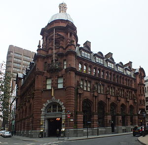
The Reform Club in Manchester, England, is a former gentlemen's club dating from the Victorian era. Built in 1870–1871 in the Venetian Gothic style, it was designed by Edward Salomons, in collaboration with an Irish architect, John Philpot Jones. The building is situated on the corner of King Street and Spring Gardens.
Estate Exchange
Building in Manchester, England
Distance: Approx. 104 meters
Latitude and longitude: 53.4806,-2.2411
The Estate Exchange at 46 Fountain Street, Manchester, England, is a Victorian office block by Thomas Worthington. It was built as Overseers' and Churchwardens' Offices in 1852, with the top two floors being added in 1858. It is a Grade II* listed building as of 2 October 1974.
Former National Westminster Bank
Building in Manchester, England
Distance: Approx. 88 meters
Latitude and longitude: 53.4811,-2.2414
The former National Westminster Bank on Spring Gardens, Manchester, England, is an Edwardian bank building constructed in 1902 for Parr's Bank by Charles Heathcote. The bank is in a "bold Edwardian Baroque" style. It is a Grade II* listed building as of 4 January 1972.

53 King Street
Distance: Approx. 121 meters
Latitude and longitude: 53.48125,-2.2443
53 King Street is an Edwardian Baroque bank on King Street in Manchester, England. Designed by architect Charles Heathcote, it opened in 1913 and was granted Grade II listed building status in 1974. It used to house a branch of Lloyds TSB. In 2009, the building was sold for £6 million.

46–48 Brown Street
Building in Manchester, England
Distance: Approx. 31 meters
Latitude and longitude: 53.48054,-2.24279
46–48 Brown Street is a Grade II listed building in Manchester, England. Situated in the Spring Gardens area of Manchester city centre near King Street, it was home to Brook's Bank. The building is also known as Lombard Chambers.

Ship Canal House
Building in Manchester, England
Distance: Approx. 33 meters
Latitude and longitude: 53.4807,-2.2431
Ship Canal House is a building in Manchester, England, which was built in 1927 for the Manchester Ship Canal Company. The building is located on King Street, historically the centre for Manchester's banking industry. The building was designed by Harry S Fairhurst in a neo-classical style and displays some Art Deco and Edwardian Baroque motifs, such as square windows and roof sculptures which were prevalent during the 1920s.
Spring Gardens, Manchester
Street in Manchester, England
Distance: Approx. 88 meters
Latitude and longitude: 53.4811,-2.2414
Spring Gardens is an important thoroughfare in Manchester city centre, England. This L-shaped street, formerly the centre of the North West's banking industry, has five Grade II listed buildings and is part of the Upper King Street conservation area.

Manchester Stock Exchange
Hotel, formerly a stock exchange in Manchester, England
Distance: Approx. 135 meters
Latitude and longitude: 53.48201,-2.24248
The Manchester Stock Exchange, later a branch of the Northern Stock Exchange, is now a Grade II listed hotel. at 2–6 Norfolk Street, Manchester. It was built at a cost of £86,000, between 1904 and 1906 by Bradshaw, Gass and Hope, the Bolton architectural practice responsible for many of Manchester's iconic buildings.
Weather in this IP's area
mist
11 Celsius
10 Celsius
10 Celsius
12 Celsius
1033 hPa
94 %
1033 hPa
1026 hPa
1200 meters
1.03 m/s
320 degree
100 %
07:33:22
16:13:43


