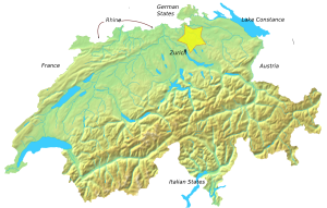
Country:
 Switzerland
Region:
City:
Latitude and Longitude:
Time Zone:
Postal Code:
IP information under different IP Channel
ip-api
Country
Region
City
ASN
Time Zone
ISP
Blacklist
Proxy
Latitude
Longitude
Postal
Route
IPinfo
Country
Region
City
ASN
Time Zone
ISP
Blacklist
Proxy
Latitude
Longitude
Postal
Route
MaxMind
Country
Region
City
ASN
Time Zone
ISP
Blacklist
Proxy
Latitude
Longitude
Postal
Route
Luminati
Country
CHRegion
zh
City
winterthur
ASN
Time Zone
Europe/Zurich
ISP
System-clinch
Latitude
Longitude
Postal
db-ip
Country
Region
City
ASN
Time Zone
ISP
Blacklist
Proxy
Latitude
Longitude
Postal
Route
ipdata
Country
Region
City
ASN
Time Zone
ISP
Blacklist
Proxy
Latitude
Longitude
Postal
Route
Popular places and events near this IP address

Winterthur
City in the canton of Zürich, Switzerland
Distance: Approx. 1191 meters
Latitude and longitude: 47.49888889,8.72861111
Winterthur (German pronunciation: [ˈvɪntɐtuːɐ̯] ; French: Winterthour) is a city in the canton of Zürich in northern Switzerland. With over 120,000 residents, it is the country's sixth-largest city by population, as well as its ninth-largest agglomeration with about 140,000 inhabitants. Located about 20 kilometres (12 mi) northeast of Zürich, Winterthur is a service and high-tech industrial satellite city within Greater Zürich.

Altstadt
German language word for "old town"
Distance: Approx. 1191 meters
Latitude and longitude: 47.49888889,8.72861111
Altstadt (German: [ˈaltˌʃtat] ) is the German language word for "old town", and generally refers to the historical town or city centre within the old town or city wall, in contrast to younger suburbs outside. Neustadt (new town), the logical opposite of Altstadt, mostly stands for a part of the "Altstadt" in modern sense, sometimes only a few years younger than the oldest part, e. g.

Mattenbach
District in Zürich, Switzerland
Distance: Approx. 742 meters
Latitude and longitude: 47.487,8.747
Mattenbach is a district in the Swiss city of Winterthur. It is district number 7. The district comprises the quarters Deutweg, Gutschick and Endliker.
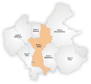
Stadt (Winterthur)
District in Zürich, Switzerland
Distance: Approx. 1182 meters
Latitude and longitude: 47.499,8.729
Stadt is a district in the Swiss city of Winterthur. It is district number 1, thus mainly comprising the original city. The district comprises the quarters Altstadt, Lind, Heiligberg, Tössfeld, Brühlberg and Neuwiesen.

Waser
Distance: Approx. 1388 meters
Latitude and longitude: 47.48638889,8.75611111
Waser is a quarter in the district 3 of Winterthur. It was formerly a part of Seen municipality, which was incorporated into Winterthur in 1922.

Grüze
Distance: Approx. 1488 meters
Latitude and longitude: 47.49888889,8.75444444
Grüze is a quarter in the district 2 of Winterthur, Switzerland. It was a part of Oberwinterthur municipality, which was incorporated into Winterthur in 1922.
Battle of Winterthur
1799 battle of the French Revolutionary Wars
Distance: Approx. 1335 meters
Latitude and longitude: 47.5,8.75
The Battle of Winterthur (27 May 1799) was an important action between elements of the Army of the Danube and elements of the Habsburg army, commanded by Friedrich Freiherr von Hotze, during the War of the Second Coalition, part of the French Revolutionary Wars. The small town of Winterthur lies 18 kilometers (11 mi) northeast of Zürich, in Switzerland. Because of its position at the junction of seven roads, the army that held the town controlled access to most of Switzerland and points crossing the Rhine into southern Germany.

Kunstmuseum Winterthur
Art museum in Winterthur, Switzerland
Distance: Approx. 1352 meters
Latitude and longitude: 47.50138889,8.73027778
The Kunst Museum Winterthur (The Winterthur Museum of Art) is an art museum in Winterthur, Switzerland run by the local Kunstverein. From its beginnings, the activities of the Kunstverein Winterthur were focused on contemporary art – first Impressionism, then Post-Impressionism and especially Les Nabis, through post-World War II and recently created works by Richard Hamilton, Mario Merz and Gerhard Richter.
Zurich University of Applied Sciences/ZHAW
University in Zurich, Switzerland
Distance: Approx. 960 meters
Latitude and longitude: 47.49694444,8.73
The Zurich University of Applied Sciences (ZHAW; ‹See Tfd›German: Zürcher Hochschule für Angewandte Wissenschaften) located in the city of Winterthur, with facilities in Zurich and Wädenswil, is one of the largest University of Applied Sciences in Switzerland and is part of the Zürcher Fachhochschule. Currently, the university has eight departments, covering architecture and civil engineering, health, linguistics, life sciences and facility management, applied psychology, social work, engineering and management and law. The ZHAW School of Management and Law obtained AACSB accreditation in 2015.

Fotomuseum Winterthur
Art museum in Winterthur, Switzerland
Distance: Approx. 592 meters
Latitude and longitude: 47.49602,8.73902
Fotomuseum Winterthur is a museum of photography in Winterthur, Switzerland.

Winterthur Grüze railway station
Swiss railway station
Distance: Approx. 1284 meters
Latitude and longitude: 47.49875306,8.75101889
Winterthur Grüze railway station (‹See Tfd›German: Bahnhof Winterthur Grüze) is a railway station that serves Grüze, an industrial zone in district number 2, Winterthur, a city in the canton of Zürich, Switzerland. Opened in 1855, the station was built as a junction station and is the largest freight hub in Winterthur. It forms part of both the Tösstal line and the St.

Vitudurum
Former Roman Vicus in Switzerland
Distance: Approx. 1114 meters
Latitude and longitude: 47.5,8.73333333
Vitudurum (sometimes Vitodorum) is the name of a Roman vicus, those remains are located in Oberwinterthur, a locality of the municipality of Winterthur in the canton of Zürich in Switzerland.
Weather in this IP's area
broken clouds
11 Celsius
11 Celsius
10 Celsius
12 Celsius
1010 hPa
90 %
1010 hPa
958 hPa
10000 meters
3.6 m/s
120 degree
75 %
07:31:06
18:54:48