Country:
 Germany
Region:
City:
Latitude and Longitude:
Time Zone:
Postal Code:
IP information under different IP Channel
ip-api
Country
Region
City
ASN
Time Zone
ISP
Blacklist
Proxy
Latitude
Longitude
Postal
Route
IPinfo
Country
Region
City
ASN
Time Zone
ISP
Blacklist
Proxy
Latitude
Longitude
Postal
Route
MaxMind
Country
Region
City
ASN
Time Zone
ISP
Blacklist
Proxy
Latitude
Longitude
Postal
Route
Luminati
Country
DERegion
he
City
frankfurtammain
ASN
Time Zone
Europe/Berlin
ISP
true global communications GmbH
Latitude
Longitude
Postal
db-ip
Country
Region
City
ASN
Time Zone
ISP
Blacklist
Proxy
Latitude
Longitude
Postal
Route
ipdata
Country
Region
City
ASN
Time Zone
ISP
Blacklist
Proxy
Latitude
Longitude
Postal
Route
Popular places and events near this IP address

Bonames
Quarter of Frankfurt am Main in Hesse, Germany
Distance: Approx. 1756 meters
Latitude and longitude: 50.18527778,8.66472222
Bonames is a quarter of Frankfurt am Main, Germany. It is part of the Ortsbezirk Nord-Ost. The name comes from the Latin phrase "bona mansio" (literally: good harborage) which has its roots in the time of the Roman rule.

Frankfurter Berg
Quarter of Frankfurt am Main in Hesse, Germany
Distance: Approx. 2817 meters
Latitude and longitude: 50.1725,8.67861111
Frankfurter Berg is a quarter of Frankfurt am Main, Germany, situated on a hill above the river Nidda. It is part of the Ortsbezirk Nord-Ost.

Harheim
Borough of Frankfurt am Main in Hesse, Germany
Distance: Approx. 1768 meters
Latitude and longitude: 50.18361111,8.69083333
Harheim (German pronunciation: [ˈhaːɐ̯haɪm]) is a borough (Ortsbezirk) of Frankfurt am Main, Germany. It is a possible birthplace of the Minnesinger Bernger von Horheim.

Nieder-Erlenbach
Borough of Frankfurt am Main in Hesse, Germany
Distance: Approx. 2161 meters
Latitude and longitude: 50.20305556,8.70888889
Nieder-Erlenbach is since 1 August 1972 the northernmost borough (Ortsbezirk) of Frankfurt am Main, Germany. The Anna-Schmidt-Schule, a private school, is located in Nieder-Erlenbach.

Nieder-Eschbach
Borough of Frankfurt am Main in Hesse, Germany
Distance: Approx. 1463 meters
Latitude and longitude: 50.20638889,8.66416667
Nieder-Eschbach is a borough (Ortsbezirk) of Frankfurt am Main, Germany. After 1465 Nieder-Eschbach belonged to the Archbishopric of Mainz. Ecclesiastical Middle Authority was the Archdeacon of the provost of St.
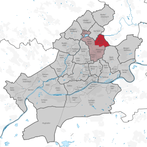
Berkersheim
Quarter of Frankfurt am Main in Hesse, Germany
Distance: Approx. 3117 meters
Latitude and longitude: 50.17222222,8.6975
Berkersheim is a quarter of Frankfurt am Main, Germany. It is part of the Ortsbezirk Nord-Ost. Berkersheim had been an independent town until 1910 when it was suburbanised.

Kalbach-Riedberg
Borough of Frankfurt am Main in Hesse, Germany
Distance: Approx. 3217 meters
Latitude and longitude: 50.18472222,8.63944444
Kalbach-Riedberg is a borough (Ortsbezirk) of Frankfurt am Main, Germany. It is subdivided into the Stadtbezirke Kalbach and Riedberg. Kalbach has a long history and has been mentioned in documented sources as early as year 772.

Eschbach (Nidda)
River of Hesse, Germany
Distance: Approx. 2272 meters
Latitude and longitude: 50.18111111,8.69805556
Eschbach is a river of Hesse, Germany. It is a tributary of the Nidda near Bad Vilbel. From the confluence of its source rivers Dornbach and Heuchelbach to its outflow into the Nidda, is 8.1 km long.

Kalbach (Nidda)
River in Germany
Distance: Approx. 2425 meters
Latitude and longitude: 50.17833333,8.66444444
Kalbach is a small river of Hesse, Germany. It flows into the Nidda in Bonames.

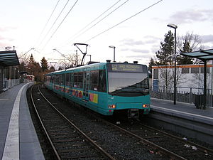
Frankfurt-Frankfurter Berg station
Railway station in Frankfurt, Germany
Distance: Approx. 3100 meters
Latitude and longitude: 50.17,8.67722222
Frankfurt-Frankfurter Berg station (German: Bahnhof Frankfurt-Frankfurter Berg) is a railway station located in the Frankfurter Berg district of Frankfurt, Germany. The station is classified by Deutsche Bahn as a category 5 station and part of the Main–Weser Railway. The station was called Bonames until 1996.

Frankfurt-Berkersheim station
Railway station in Germany
Distance: Approx. 2709 meters
Latitude and longitude: 50.17638889,8.69777778
Frankfurt-Berkersheim station is a railway station in the Berkersheim district of Frankfurt, Germany.
Bad Homburg Gonzenheim (Frankfurt U-Bahn)
Station on line U2 of the Frankfurt U-Bahn, Germany
Distance: Approx. 3651 meters
Latitude and longitude: 50.219,8.6406
Bad Homburg Gonzenheim is a station on line U2 of the Frankfurt U-Bahn. It is located in the Gonzenheim district of Bad Homburg vor der Höhe, in Hesse, Germany. Known for its spacious platform.
Weather in this IP's area
overcast clouds
20 Celsius
20 Celsius
18 Celsius
21 Celsius
1009 hPa
85 %
1009 hPa
995 hPa
10000 meters
3.88 m/s
6.5 m/s
217 degree
94 %
06:51:04
19:55:03