Country:
 Austria
Region:
City:
Latitude and Longitude:
Time Zone:
Postal Code:
IP information under different IP Channel
ip-api
Country
Region
City
ASN
Time Zone
ISP
Blacklist
Proxy
Latitude
Longitude
Postal
Route
IPinfo
Country
Region
City
ASN
Time Zone
ISP
Blacklist
Proxy
Latitude
Longitude
Postal
Route
MaxMind
Country
Region
City
ASN
Time Zone
ISP
Blacklist
Proxy
Latitude
Longitude
Postal
Route
Luminati
Country
ATASN
Time Zone
Europe/Vienna
ISP
euNetworks GmbH
Latitude
Longitude
Postal
db-ip
Country
Region
City
ASN
Time Zone
ISP
Blacklist
Proxy
Latitude
Longitude
Postal
Route
ipdata
Country
Region
City
ASN
Time Zone
ISP
Blacklist
Proxy
Latitude
Longitude
Postal
Route
Popular places and events near this IP address

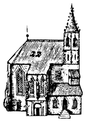
St. Stephen's Cathedral, Vienna
Church in Vienna, Austria
Distance: Approx. 68 meters
Latitude and longitude: 48.2085,16.373
St. Stephen's Cathedral (German: Stephansdom [ˈʃ͡tɛfansˌdoːm]) is the mother church of the Roman Catholic Archdiocese of Vienna and the seat of the archbishop of Vienna, Christoph Cardinal Schönborn, OP. The current Romanesque and Gothic form of the cathedral, seen today in the Stephansplatz, was largely initiated by Duke Rudolf IV (1339–1365) and stands on the ruins of two earlier churches, the first a parish church consecrated in 1147. The most important religious building in Vienna, St.

Siege of Vienna (1529)
Failed siege of the Ottoman–Habsburg wars
Distance: Approx. 53 meters
Latitude and longitude: 48.2083,16.3731
The Siege of Vienna, in 1529, was the first attempt by the Ottoman Empire to capture the capital city of Vienna, Austria, Holy Roman Empire. Suleiman the Magnificent, sultan of the Ottomans, attacked the city with over 100,000 men, while the defenders, led by Niklas Graf Salm, numbered no more than 21,000. Nevertheless, Vienna was able to survive the siege, which ultimately lasted just over two weeks, from 27 September to 15 October, 1529.
Vergilius Chapel
Underground crypt in Vienna, Austria
Distance: Approx. 119 meters
Latitude and longitude: 48.2083,16.3722
The Vergilius Chapel (German: Virgilkapelle) is an underground crypt next to the Stephansdom in Vienna. It is rectangular in form (approximately 6 meters by 10), with six niches. Today, it lies approximately 12 meters beneath the Stephansplatz.
Pummerin
Bell in St. Stephen's Cathedral in Vienna
Distance: Approx. 72 meters
Latitude and longitude: 48.20861111,16.37305556
Pummerin is the name of the bell in the Stephansdom, St. Stephen's Cathedral, in Vienna.

Ducal Crypt, Vienna
Burial chamber beneath the chancel of Stephansdom in Vienna, Austria
Distance: Approx. 77 meters
Latitude and longitude: 48.20833,16.37278
The Ducal Crypt (German: Herzogsgruft) is a burial chamber beneath the chancel of Stephansdom in Vienna, Austria. It holds 78 containers with the bodies, hearts, or viscera of 72 members of the House of Habsburg.

Church of the Teutonic Order, Vienna
Distance: Approx. 109 meters
Latitude and longitude: 48.2075,16.37277778
The Church of the Teutonic Order (German: Deutschordenskirche), also known as the Church of Saint Elisabeth of Hungary (German: Hl. Elisabeth von Ungarn), is the mother church of the Teutonic Order, a German-based Roman Catholic religious order formed at the end of the 12th century. Located in Vienna, Austria, near the Stephansdom, it is the current seat of the Grand Master of the Order.
Stephansplatz, Vienna
Square in Vienna, Austria
Distance: Approx. 101 meters
Latitude and longitude: 48.20841667,16.37247222
The Stephansplatz is a square at the geographical centre of Vienna, Austria. It is named after its most prominent building, the Stephansdom, Vienna's cathedral and one of the tallest churches in the world. Before the 20th century, a row of houses separated Stephansplatz from Stock-im-Eisen-Platz, but since their destruction, the name Stephansplatz started to be used for the wider area covering both.
Roman Catholic Archdiocese of Vienna
Catholic ecclesiastical territory
Distance: Approx. 62 meters
Latitude and longitude: 48.2085,16.3731
The Archdiocese of Vienna (Latin: Archidioecesis Viennensis) is a Latin Church archdiocese of the Catholic Church in Austria. It was erected as the Diocese of Vienna on 18 January 1469 out of the Diocese of Passau, and elevated to an archdiocese on 1 June 1722. The episcopal see is situated in the cathedral of S. Stephen in Vienna.

Mozarthaus Vienna
Mozart's residence from 1784 to 1787
Distance: Approx. 119 meters
Latitude and longitude: 48.20777778,16.37527778
The Mozarthaus Vienna (also known as the Figaro House) was Mozart's residence from 1784 to 1787. The building is located in Vienna's Old Town, not far from St. Stephen's Cathedral, and is his only surviving Viennese residence.

Trams in Vienna
Overview of the tram system of Vienna, Austria
Distance: Approx. 94 meters
Latitude and longitude: 48.20816667,16.37253611
Trams in Vienna (German: Wiener Straßenbahn, in everyday speech also Bim or Tramway) are a vital part of the public transport system in Vienna, capital city of Austria. In operation since 1865, with the completion of a 2 km (1.2 mi) route to industrial estates near Simmering, it reached its maximum extent of 292 km (181.4 mi) in 1942. In February 2015, it was the fifth largest tram network in the world, at about 176.9 kilometres (109.9 mi) in total length and 1,071 stations.

Siege of Vienna (1485)
Siege during the Austrian-Hungarian War
Distance: Approx. 57 meters
Latitude and longitude: 48.20833056,16.37306111
The Siege of Vienna was a decisive siege in 1485 of the Austrian–Hungarian War. It was a consequence of the ongoing conflict between Frederick III and Matthias Corvinus. After the fall of Vienna it was merged with Hungary from 1485 to 1490.
Timeline of Vienna
Distance: Approx. 57 meters
Latitude and longitude: 48.208333,16.373056
The following is a timeline of the history of the city of Vienna, Austria.
Weather in this IP's area
few clouds
30 Celsius
30 Celsius
29 Celsius
32 Celsius
1008 hPa
43 %
1008 hPa
987 hPa
10000 meters
8.23 m/s
150 degree
20 %
06:22:17
19:22:17