Country:
Region:
City:
Latitude and Longitude:
Time Zone:
Postal Code:
IP information under different IP Channel
ip-api
Country
Region
City
ASN
Time Zone
ISP
Blacklist
Proxy
Latitude
Longitude
Postal
Route
Luminati
Country
Region
m
City
rishonletsiyyon
ASN
Time Zone
Asia/Jerusalem
ISP
ITC NG ltd
Latitude
Longitude
Postal
IPinfo
Country
Region
City
ASN
Time Zone
ISP
Blacklist
Proxy
Latitude
Longitude
Postal
Route
db-ip
Country
Region
City
ASN
Time Zone
ISP
Blacklist
Proxy
Latitude
Longitude
Postal
Route
ipdata
Country
Region
City
ASN
Time Zone
ISP
Blacklist
Proxy
Latitude
Longitude
Postal
Route
Popular places and events near this IP address

Rishon LeZion
City in Israel
Distance: Approx. 1967 meters
Latitude and longitude: 31.95,34.8
Rishon LeZion (Hebrew: רִאשׁוֹן לְצִיּוֹן , lit. "First to Zion") is a city in Israel, located along the central Israeli coastal plain eight kilometres (5 mi) south of Tel Aviv. It is part of the Gush Dan metropolitan area.

Ness Ziona
City in Central District, Israel
Distance: Approx. 3630 meters
Latitude and longitude: 31.93333333,34.8
Ness Ziona (Hebrew: נֵס צִיּוֹנָה, Nes Tziyona) is a city in Central District, Israel. In 2022 it had a population of 50,341, and its jurisdiction was 15,579 dunams (15.579 km2 [6.015 sq mi]).
Gymnasia Realit
Israeli high school
Distance: Approx. 963 meters
Latitude and longitude: 31.96142778,34.79726389
The Gimnasia Realit or the Gimnasia Realit E. Karary (הגימנסיה הריאלית על שם א. קררי) is an Israeli high school, named in honor of its first principal Eliezer Karary.

Neta'im
Moshav in central Israel
Distance: Approx. 2475 meters
Latitude and longitude: 31.94555556,34.77333333
Neta'im (Hebrew: נְטָעִים, lit. Plantations), is a moshav in central Israel. Located in the coastal plain around 4 kilometres south of Rishon LeZion and covering 1,100 dunams, it falls under the jurisdiction of Gan Raveh Regional Council.

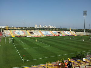
Haberfeld Stadium
Distance: Approx. 3496 meters
Latitude and longitude: 31.97499444,34.75283889
Haberfeld Stadium (Hebrew: אצטדיון הברפלד, Itztadion Haberfeld; also known as the Superland Stadium) is a multi-purpose stadium in Rishon LeZion, Israel. It is currently used mostly for football matches and is the home stadium of Hapoel Rishon LeZion. The stadium holds 6,000 and was built in 1993.

Beit Hanan
Moshav in central Israel
Distance: Approx. 3596 meters
Latitude and longitude: 31.93444444,34.77277778
Beit Hanan (Hebrew: בֵּית חָנָן) is a moshav in central Israel. Located around two kilometers west of Ness Ziona, it falls under the jurisdiction of Gan Raveh Regional Council. In 2022 its population was 509.

Rishon LeZion–HaRishonim railway station
Railway station in Israel
Distance: Approx. 2183 meters
Latitude and longitude: 31.948875,34.80201667
Rishon LeZion–HaRishonim railway station (Hebrew: תחנת הרכבת ראשון לציון – הראשונים, Tahanat HaRakevet Rishon LeTziyon HaRishonim) is a station of Israel Railways in Rishon LeZion, part of the Tel Aviv – Rishon LeZion line. The station is located in the southern area of the city, in the middle of HaRishonim Interchange, at the intersection of the new Highway 431 and Route 412 (Rishon LeZion – Nes Ziona road). It was opened on September 13, 2003, with the Beit Shemesh railway station.
Gan Sorek
Moshav in central Israel
Distance: Approx. 3431 meters
Latitude and longitude: 31.94416667,34.76
Gan Sorek (Hebrew: גַּן שׂוֹרֵק, lit. 'Sorek Garden') is a moshav in central Israel. Located in the coastal plain, approximately four kilometres southwest of Rishon LeZion and covering 700 dunams, it falls under the jurisdiction of Gan Raveh Regional Council. In 2022 it had a population of 703.

Sarafand al-Kharab
Place in Ramle, Mandatory Palestine
Distance: Approx. 3530 meters
Latitude and longitude: 31.93638889,34.80555556
Sarafand al-Kharab (Arabic: صرفند الخراب) was a Palestinian Arab village in the Ramle Subdistrict, located 50 meters (160 ft) above sea level, 7 kilometers (4.3 mi) west of Ramla, in the area that is today northeast of Ness Ziona.

College of Management Academic Studies
Institute of higher education in Israel
Distance: Approx. 1616 meters
Latitude and longitude: 31.97035,34.772104
The College of Management Academic Studies, a college located in the city of Rishon LeZion, Israel, is the largest college in Israel. The College has an additional campus in the city of Bnei Brak. Founded in 1978, COLMAN is the first non-subsidized, not-for-profit research academic institution in Israel to be recognized and certified by the Council for Higher Education in Israel.

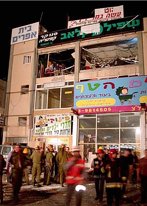
2002 Rishon LeZion bombing
Palestinian suicide attack in Israel
Distance: Approx. 3511 meters
Latitude and longitude: 31.9918,34.7696
The 2002 Rishon LeZion bombing was a suicide bombing which occurred on 7 May 2002 at a crowded game club located in the new industrial area of Rishon Lezion, Israel. 16 people were killed in the attack and 55 were injured. The Islamic militant group Hamas claimed responsibility for the attack.

Haviv Elementary School
School in Rishon Lezion, Israel
Distance: Approx. 1909 meters
Latitude and longitude: 31.9637,34.8078
Haviv elementary school (Hebrew: בית הספר חביב) is the first Hebrew school in the world. It was established in 1886 in Rishon LeZion and is still active to this day.
Weather in this IP's area
clear sky
28 Celsius
28 Celsius
27 Celsius
29 Celsius
1017 hPa
44 %
1017 hPa
1010 hPa
10000 meters
1.54 m/s
06:03:33
16:45:44

