Country:
Region:
City:
Latitude and Longitude:
Time Zone:
Postal Code:
IP information under different IP Channel
ip-api
Country
Region
City
ASN
Time Zone
ISP
Blacklist
Proxy
Latitude
Longitude
Postal
Route
Luminati
Country
Region
11
City
vaduz
ASN
Time Zone
Europe/Vaduz
ISP
Telecom Liechtenstein AG
Latitude
Longitude
Postal
IPinfo
Country
Region
City
ASN
Time Zone
ISP
Blacklist
Proxy
Latitude
Longitude
Postal
Route
db-ip
Country
Region
City
ASN
Time Zone
ISP
Blacklist
Proxy
Latitude
Longitude
Postal
Route
ipdata
Country
Region
City
ASN
Time Zone
ISP
Blacklist
Proxy
Latitude
Longitude
Postal
Route
Popular places and events near this IP address

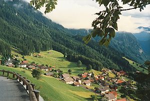
Triesenberg
Municipality in Oberland, Liechtenstein
Distance: Approx. 522 meters
Latitude and longitude: 47.11805556,9.54333333
Triesenberg (German pronunciation: [ˈtʁiːzn̩ˌbɛʁk] ) is a municipality in Liechtenstein with a population of 2,636. Its area of 29.69 square kilometres (11.46 sq mi) makes it the largest municipality in Liechtenstein. The center of the municipality rests at an elevation of 884–1,000 metres (2,900–3,281 ft).

Triesen
Municipality in Oberland, Liechtenstein
Distance: Approx. 1653 meters
Latitude and longitude: 47.1,9.53333333
Triesen (German pronunciation: [ˈtʁiːzn̩] ) is the third largest municipality in Liechtenstein. It contains several historic churches dating from the fifteenth century. It also has a weaving mill from 1863 that is considered a historical monument.

Roman Catholic Archdiocese of Vaduz
Catholic archdiocese in Liechtenstein
Distance: Approx. 2733 meters
Latitude and longitude: 47.1362,9.5229
The Archdiocese of Vaduz (Latin: Archidioecesis Vaduzensis), which was erected in 1997, is a Latin Church diocese of the Catholic Church which encompasses the entire territory of the Principality of Liechtenstein.
Masescha
Village in Oberland, Liechtenstein
Distance: Approx. 2095 meters
Latitude and longitude: 47.13277778,9.54444444
Masescha is a village of Liechtenstein, located in the municipality of Triesenberg.

Silum
Village in Oberland, Liechtenstein
Distance: Approx. 2271 meters
Latitude and longitude: 47.13333333,9.55
Silum is a village of Liechtenstein, located in the municipality of Triesenberg.
Rotenboden
Village in Oberland, Liechtenstein
Distance: Approx. 1655 meters
Latitude and longitude: 47.12916667,9.53888889
Rotenboden (also spelled Rotaboda) is a village of Liechtenstein, located in the municipality of Triesenberg. It is the highest settlement in Liechtenstein at 850m elevation.
Sücka
Village in Oberland, Liechtenstein
Distance: Approx. 2097 meters
Latitude and longitude: 47.11666667,9.56666667
Sücka is a village of Liechtenstein, located in the municipality of Triesenberg.
Wangerberg
Village in Oberland, Liechtenstein
Distance: Approx. 994 meters
Latitude and longitude: 47.10611111,9.54444444
Wangerberg (also spelled Wangerbärg) is a village of Liechtenstein, located in the municipality of Triesenberg.
Sportanlage Blumenau
Football stadium in Triesen, Liechtenstein
Distance: Approx. 1561 meters
Latitude and longitude: 47.1102,9.5195
Sportanlage Blumenau is a football stadium in Triesen, Liechtenstein. It has a capacity of 2,100 and is the home of FC Triesen.
Sportanlage Leitawies
Football stadium in Triesenberg, Liechtenstein
Distance: Approx. 72 meters
Latitude and longitude: 47.1145,9.5401
Sportanlange Leitawies is a football stadium in Triesenberg, Liechtenstein. It is the home ground of FC Triesenberg and has a capacity of 800 made up of 400 seats and 400 standing places.
Private University in the Principality of Liechtenstein
Private medical school located in Liechtenstein
Distance: Approx. 1171 meters
Latitude and longitude: 47.1082,9.5266
The Private University in the Principality of Liechtenstein (German: Private Universität im Fürstentum Liechtenstein (UFL)) is one of the four centers for higher education in the Principality of Liechtenstein. It focuses on two main fields of study: Medical Sciences and Law. The university is located in Triesen.

Biosphere Reserve Großes Walsertal
Austrian nature reserve
Distance: Approx. 1930 meters
Latitude and longitude: 47.13,9.55
The Biosphere Reserve Großes Walsertal (German: Biosphärenpark Großes Walsertal) is a protected nature reserve in the Austrian state of Vorarlberg. The area of the nature reserve covers 19,231 ha. There are 3,420 inhabitants and around 180 farms (42 % of which are organic).
Weather in this IP's area
broken clouds
7 Celsius
7 Celsius
6 Celsius
8 Celsius
1028 hPa
92 %
1028 hPa
942 hPa
10000 meters
1.2 m/s
1.2 m/s
185 degree
61 %
07:06:34
17:04:09