217.173.175.35 - IP Lookup: Free IP Address Lookup, Postal Code Lookup, IP Location Lookup, IP ASN, Public IP
Country:
Region:
City:
Location:
Time Zone:
Postal Code:
ISP:
ASN:
language:
User-Agent:
Proxy IP:
Blacklist:
IP information under different IP Channel
ip-api
Country
Region
City
ASN
Time Zone
ISP
Blacklist
Proxy
Latitude
Longitude
Postal
Route
db-ip
Country
Region
City
ASN
Time Zone
ISP
Blacklist
Proxy
Latitude
Longitude
Postal
Route
IPinfo
Country
Region
City
ASN
Time Zone
ISP
Blacklist
Proxy
Latitude
Longitude
Postal
Route
IP2Location
217.173.175.35Country
Region
slaskie
City
ruda slaska
Time Zone
Europe/Warsaw
ISP
Language
User-Agent
Latitude
Longitude
Postal
ipdata
Country
Region
City
ASN
Time Zone
ISP
Blacklist
Proxy
Latitude
Longitude
Postal
Route
Popular places and events near this IP address

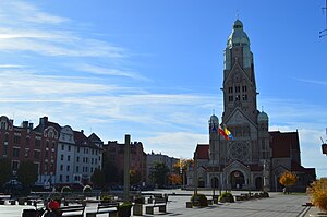
Ruda Śląska
City in Silesian Voivodeship, Poland
Distance: Approx. 524 meters
Latitude and longitude: 50.26277778,18.85361111
Ruda Śląska (German: Ruda O.S.; Silesian: Ślōnsko Ruda) is a city in Silesia in southern Poland, near Katowice. It is a city in the Metropolis GZM, a metropolis with a population of two million. It is in the Silesian Highlands, on the Kłodnica River (tributary of the Oder).

Zgoda labour camp
Polish concentration camp
Distance: Approx. 3938 meters
Latitude and longitude: 50.2794159,18.9008135
Zgoda (Polish pronunciation: [ˈzɡɔda]) was a concentration camp, set up in February 1945 in Zgoda district of Świętochłowice, Silesia. It was controlled by the communist secret police until its closure in November of the same year. Between 1943 and January 1945 during World War II, the camp in Świętochłowice operated by Nazi Germany as Arbeitslager.

Wirek
Ruda Śląska District in Silesian Voivodeship, Poland
Distance: Approx. 1878 meters
Latitude and longitude: 50.27444444,18.86444444
Wirek (German: Antonienhütte) is a district in the centre of Ruda Śląska, Silesian Voivodeship, southern Poland. In 2006 it had an area of 5.9 km2 and was inhabited by 20,595 people. On January 12, 2006 a part of it was split off to form a new district, Czarny Las.

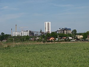
Bielszowice Coal Mine
Mine in Bielszowice, Ruda Śląska, Silesian Voivodeship, Poland
Distance: Approx. 1809 meters
Latitude and longitude: 50.2662,18.834
The Bielszowice coal mine is a large mine in the south of Poland in Bielszowice district of Ruda Śląska, Silesian Voivodeship, 267 km south-west of the capital, Warsaw. Bielszowice represents one of the largest coal reserve in Poland having estimated reserves of 284.2 million tonnes of coal. The annual coal production is around 4 million tonnes.

Halemba Coal Mine
Mine in Halemba, Ruda Śląska, Silesian Voivodeship, Poland
Distance: Approx. 1645 meters
Latitude and longitude: 50.24388889,18.85194444
The Halemba coal mine is a large mine in the south of Poland in Halemba district of Ruda Śląska, Silesian Voivodeship, 273 km south-west of the capital, Warsaw. Halemba represents one of the largest coal reserves in Poland, having estimated reserves of 120 million tonnes of coal. The annual coal production is around 3.36 million tonnes.

Halemba Power Station
Power station in Poland
Distance: Approx. 2900 meters
Latitude and longitude: 50.2325,18.85194444
Halemba Power Station (Polish: Elektrownia Halemba) is a coal-fueled power plant in Halemba district of Ruda Śląska, Silesian Voivodeship, Poland. Construction of the plant begun in 1943, organized by Nazi German administration of occupied Poland, and using forced labor from Auschwitz Concentration Camp. After the war the plant was finished by the authorities in the People's Republic of Poland, and started operation in 1962.

2006 Halemba Coal Mine disaster
2006 coal mine explosion in Poland
Distance: Approx. 1644 meters
Latitude and longitude: 50.2439,18.8519
2006 Halemba Coal Mine disaster refers to the accident of 21 November 2006 in the Halemba Coal Mine, Ruda Śląska, Poland. An explosion of methane and coal dust resulted in 23 fatalities. It was one of the largest mining disasters in Poland.

Halemba
Ruda Śląska District in Silesian Voivodeship, Poland
Distance: Approx. 2341 meters
Latitude and longitude: 50.237847,18.86328
Halemba is a district in the south-west of Ruda Śląska, Silesian Voivodeship, southern Poland. It lies on the river Kłodnica, right tritubary of Odra. It has an area of 19.6 km2 and in 2006 it was inhabited by 26,080 people.
Kochłowice, Ruda Śląska
Ruda Śląska District in Silesian Voivodeship, Poland
Distance: Approx. 3256 meters
Latitude and longitude: 50.253787,18.901469
Kochłowice (German: Kochlowitz) is a district in the south-east of Ruda Śląska, Silesian Voivodeship, southern Poland. It has an area of 17.5 km2 and in 2006 it was inhabited by 12,738 people.
Bykowina
Ruda Śląska District in Silesian Voivodeship, Poland
Distance: Approx. 3026 meters
Latitude and longitude: 50.270634,18.894274
Bykowina (German: Friedrichsdorf) is a district in the south-east of Ruda Śląska, Silesian Voivodeship, southern Poland. It has an area of 1.6 km2 and in 2006 it was inhabited by 18,267 people.

Nowy Bytom
Ruda Śląska District in Silesian Voivodeship, Poland
Distance: Approx. 3311 meters
Latitude and longitude: 50.28555556,18.87527778
Nowy Bytom (German: Friedenshütte) is a district serving as administrative centre of Ruda Śląska, Silesian Voivodeship, southern Poland. In 2006 it had an area of 4.6 km2 and was inhabited by 12,058 people. On January 12, 2006 a part of it was split off to form a new district, Czarny Las.

Bielszowice
Ruda Śląska District in Silesian Voivodeship, Poland
Distance: Approx. 1933 meters
Latitude and longitude: 50.268508,18.834216
Bielszowice (German: Bielschowitz) is a district in the west of Ruda Śląska, Silesian Voivodeship, southern Poland. In 2006 it had an area of 10.6 km2 and was inhabited by 9,505 people. On January 12, 2006 a part of it was split off to form a new district, Czarny Las.
Weather in this IP's area
broken clouds
4 Celsius
3 Celsius
3 Celsius
7 Celsius
1005 hPa
90 %
1005 hPa
973 hPa
10000 meters
2.07 m/s
2.71 m/s
182 degree
72 %

