217.173.137.5 - IP Lookup: Free IP Address Lookup, Postal Code Lookup, IP Location Lookup, IP ASN, Public IP
Country:
Region:
City:
Location:
Time Zone:
Postal Code:
IP information under different IP Channel
ip-api
Country
Region
City
ASN
Time Zone
ISP
Blacklist
Proxy
Latitude
Longitude
Postal
Route
Luminati
Country
ASN
Time Zone
Europe/Berlin
ISP
Titan Networks Internet & Telecommunications Service Providing GmbH
Latitude
Longitude
Postal
IPinfo
Country
Region
City
ASN
Time Zone
ISP
Blacklist
Proxy
Latitude
Longitude
Postal
Route
IP2Location
217.173.137.5Country
Region
hessen
City
hofheim am taunus
Time Zone
Europe/Berlin
ISP
Language
User-Agent
Latitude
Longitude
Postal
db-ip
Country
Region
City
ASN
Time Zone
ISP
Blacklist
Proxy
Latitude
Longitude
Postal
Route
ipdata
Country
Region
City
ASN
Time Zone
ISP
Blacklist
Proxy
Latitude
Longitude
Postal
Route
Popular places and events near this IP address
Main-Taunus-Kreis
District in Hesse, Germany
Distance: Approx. 1166 meters
Latitude and longitude: 50.079723,8.449307
Main-Taunus is a Kreis (district) in the middle of Hessen, Germany and is part of the Frankfurt/Rhine-Main Metropolitan Region as well as the Frankfurt urban area. Neighboring districts are Hochtaunuskreis, district-free Frankfurt, Groß-Gerau, district-free Wiesbaden, Rheingau-Taunus. It is the second most densely populated rural district in Germany.

Hofheim, Hesse
Town in Hesse, Germany
Distance: Approx. 766 meters
Latitude and longitude: 50.08333333,8.45
Hofheim (German pronunciation: [ˈhoːfˌhaɪ̯m] ; officially known as Hofheim am Taunus) is the administrative centre of Main-Taunus-Kreis district, in the south of the German state of Hesse. Its population in September 2020 was 39,946.

Zeilsheim
Quarter of Frankfurt am Main in Hesse, Germany
Distance: Approx. 3175 meters
Latitude and longitude: 50.09694444,8.4925
Zeilsheim is a quarter of Frankfurt am Main, Germany. It is part of the Ortsbezirk West and is subdivided into the Stadtbezirke Zeilsheim-Ost, Zeilsheim-Süd and Zeilsheim-Nord. As the westernmost district of Frankfurt, Zeilsheim is somewhat rural in character and the surrounding fields can give a clear view of the Taunus mountains.

Hattersheim am Main
Town in Hesse, Germany
Distance: Approx. 3320 meters
Latitude and longitude: 50.07222222,8.48638889
Hattersheim am Main (German pronunciation: [ˈhatɐsˌhaɪ̯m] ) is a town in the Main-Taunus district, Hesse (Germany) and part of the Frankfurt Rhein-Main urban area.

Kriftel
Municipality in Hesse, Germany
Distance: Approx. 766 meters
Latitude and longitude: 50.08333333,8.45
Kriftel is a municipality in the Main-Taunus district, in Hesse, Germany. It is situated 16 km west of Frankfurt (centre). It has about 11,000 inhabitants.
ISF International School Frankfurt Rhein-Main
International private education school in Frankfurt-Sindlingen, Hesse, Germany
Distance: Approx. 3945 meters
Latitude and longitude: 50.086694,8.504266
The ISF International School Frankfurt Rhein-Main is a private school in Sindlingen, a borough of Frankfurt am Main, Germany. Accredited by the Council of International Schools, the school offers IGCSE, International Baccalaureate Diploma Programme and AP examinations. The International School of Frankfurt Rhein-Main was founded in 1995 as a public-private partnership in schools within Germany by the Frankfurt Chamber of Commerce, the State of Hesse, the Frankfurt Economic Development GmbH and with financial support of international companies in the region.

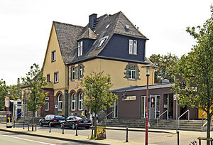
Hofheim (Taunus) station
Railway station in Hofheim am Taunus, Germany
Distance: Approx. 733 meters
Latitude and longitude: 50.08441503,8.44438791
Hofheim (Taunus) station is a station in the city of Hofheim in the German state of Hesse on the Main-Lahn Railway. The station opened on 15 November 1877, and is served by line S2 of the Rhine-Main S-Bahn and regional services operated by Deutsche Bahn. It is classified by Deutsche Bahn as a category 4 station.

Hattersheim am Main station
Railway station in Hattersheim, Hesse, Germany
Distance: Approx. 3800 meters
Latitude and longitude: 50.067703,8.489298
Hattersheim (Main) station is together with Hattersheim-Eddersheim station one of two S-Bahn stops in the town of Hattersheim, southwest of Frankfurt in the German state of Hesse. Both stations lie on the Taunus Railway (German: Taunus-Eisenbahn) from Wiesbaden to Frankfurt. The station is classified by Deutsche Bahn as a category 4 station.

Frankfurt Main Cemetery
Largest cemetery in Frankfurt, Germany
Distance: Approx. 2952 meters
Latitude and longitude: 50.08099,8.41055
The Frankfurt Main Cemetery (German: Hauptfriedhof) is the largest cemetery in Frankfurt am Main, Germany. It was opened in 1828. The cemetery is located directly adjacent to two Jewish cemeteries—the Old Jewish Cemetery (opened together with the Main Cemetery in 1828) and the New Jewish Cemetery, Frankfurt (opened in 1928)—and together they form one of the largest cemetery areas in Germany.

Poly-clip System
German family-owned company
Distance: Approx. 3846 meters
Latitude and longitude: 50.06111111,8.47833333
Poly-clip System is a German family-owned company based in Hattersheim near Frankfurt am Main. Poly-clip System is the largest provider of clip closure systems worldwide and the world market leader and hidden champion in this sector of the food industry and packaging industry.

St. Martinus, Hattersheim
Catholic church in Hesse, Germany
Distance: Approx. 3495 meters
Latitude and longitude: 50.06972222,8.48638889
St. Martinus is a Catholic church and parish in Hattersheim am Main, Main-Taunus-Kreis, Hesse, Germany. It belongs to the Diocese of Limburg.
Rhein-Main Arena
Motorcycle speedway track in Hofheim, Hesse, Germany
Distance: Approx. 3398 meters
Latitude and longitude: 50.06833333,8.41611111
The Rhein-Main Arena or Speedway Arena Diedenbergen is an 6,500 capacity motorcycle speedway and Flat track facility in Hofheim am Taunus, Germany. The track is located on the Wildsachsener Str road, on the northern outskirts of the village Diedenbergen and south west outskirts of Hofheim am Taunus. The track hosts the speedway team MSC Diedenbergen who race in the German Team Speedway Championship.
Weather in this IP's area
mist
4 Celsius
1 Celsius
3 Celsius
6 Celsius
999 hPa
96 %
999 hPa
975 hPa
4600 meters
2.57 m/s
220 degree
75 %