Country:
Region:
City:
Latitude and Longitude:
Time Zone:
Postal Code:
IP information under different IP Channel
ip-api
Country
Region
City
ASN
Time Zone
ISP
Blacklist
Proxy
Latitude
Longitude
Postal
Route
Luminati
Country
Region
naq
City
aigrefeuilledaunis
ASN
Time Zone
Europe/Paris
ISP
ADISTA SAS
Latitude
Longitude
Postal
IPinfo
Country
Region
City
ASN
Time Zone
ISP
Blacklist
Proxy
Latitude
Longitude
Postal
Route
db-ip
Country
Region
City
ASN
Time Zone
ISP
Blacklist
Proxy
Latitude
Longitude
Postal
Route
ipdata
Country
Region
City
ASN
Time Zone
ISP
Blacklist
Proxy
Latitude
Longitude
Postal
Route
Popular places and events near this IP address

Champigny-sur-Marne
Commune in Île-de-France, France
Distance: Approx. 2895 meters
Latitude and longitude: 48.8172,2.5156
Champigny-sur-Marne (French pronunciation: [ʃɑ̃piɲi syʁ maʁn] , literally Champigny on Marne) is a major city in the region of Île-de-France, France. It is located 12.5 km (7.8 mi) from the centre of Paris.

Ormesson-sur-Marne
Commune in Île-de-France, France
Distance: Approx. 1257 meters
Latitude and longitude: 48.7858,2.5383
Ormesson-sur-Marne (French pronunciation: [ɔʁmɛsɔ̃ syʁ maʁn] , literally Ormesson on Marne) is a commune in the southeastern suburbs of Paris, France. It is located 16.1 km (10.0 mi) from the center of Paris.

Battle of Villiers
Distance: Approx. 2895 meters
Latitude and longitude: 48.8172,2.5156
The Battle of Villiers, also called the Battle of Champigny, was the largest of the French sorties from besieged Paris during the Franco-Prussian War.

La Queue-en-Brie
Commune in Île-de-France, France
Distance: Approx. 2826 meters
Latitude and longitude: 48.79,2.5775
La Queue-en-Brie (French: [la kø ɑ̃ bʁi] , literally La Queue in Brie) is a commune in the southeastern suburbs of Paris, France. It is located 17.9 km (11.1 mi) from the center of Paris.

Noiseau
Commune in Île-de-France, France
Distance: Approx. 2291 meters
Latitude and longitude: 48.7769,2.5472
Noiseau (French pronunciation: [nwazo] ) is a commune in the southeastern suburbs of Paris, France. It is located 16.8 km (10.4 mi) from the center of Paris.

Chennevières-sur-Marne
Commune in Île-de-France, France
Distance: Approx. 502 meters
Latitude and longitude: 48.7983,2.5339
Chennevières-sur-Marne (French pronunciation: [ʃɛn(ə)vjɛʁ syʁ maʁn], literally Chennevières on Marne) is a commune in the southeastern suburbs of Paris, France. It is located 14.7 km (9.1 mi) from the center of Paris.
Le Plessis-Trévise
Commune in Île-de-France, France
Distance: Approx. 2777 meters
Latitude and longitude: 48.8111,2.5717
Le Plessis-Trévise (French pronunciation: [lə plɛsi tʁeviz] ) is a commune in the eastern suburbs of Paris, France. It is located 17.4 km (10.8 mi) from the center of Paris.
Fort de Champigny
Distance: Approx. 880 meters
Latitude and longitude: 48.803611,2.533889
Fort de Champigny was built following the Franco-Prussian War to defend Paris. Located to the southeast of Paris in Chennevières-sur-Marne, the fort was part of an outer ring of fortifications built in response to improvements in the range and effectiveness of artillery since the construction of the Thiers fortifications of the 1840s. It was built in accordance with improved principles of fortification developed for the Séré de Rivières system.
Champigny station
Distance: Approx. 2525 meters
Latitude and longitude: 48.80722222,2.50972222
Champigny station is a railway station in the commune of Saint-Maur-des-Fossés, near the town Champigny-sur-Marne, Val-de-Marne, France. Champigny is on the A2 branch of the RER A with eastbound trains to Boissy-Saint-Léger and westbound trains to Saint-Germain-en-Laye. It is situated on the Grande Ceinture line.
La Varenne–Chennevières station
Distance: Approx. 2041 meters
Latitude and longitude: 48.795,2.5128
La Varenne–Chennevières station is a French railway station in Saint-Maur-des-Fossés, in Val-de-Marne, France.
Canton of Champigny-sur-Marne-2
Distance: Approx. 1607 meters
Latitude and longitude: 48.81,2.55
The canton of Champigny-sur-Marne-2 is an administrative division of the Val-de-Marne department, Île-de-France region, northern France. It was created at the French canton reorganisation which came into effect in March 2015. Its seat is in Champigny-sur-Marne.

Church of St. Peter, Chennevières-sur-Marne
Roman Catholic church in Chennevières-sur-Marne, Val-de-Marne, France
Distance: Approx. 779 meters
Latitude and longitude: 48.795,2.53027778
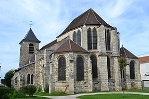
The Church of St. Peter (French: église Saint-Pierre) is a Roman Catholic church in Chennevières-sur-Marne, Val-de-Marne, France. It is partly listed as a Class Historic Monument.
Weather in this IP's area
mist
7 Celsius
4 Celsius
6 Celsius
8 Celsius
1018 hPa
94 %
1018 hPa
1005 hPa
4500 meters
4.47 m/s
4.47 m/s
210 degree
75 %
08:02:20
17:07:41


