217.171.110.200 - IP Lookup: Free IP Address Lookup, Postal Code Lookup, IP Location Lookup, IP ASN, Public IP
Country:
Region:
City:
Location:
Time Zone:
Postal Code:
IP information under different IP Channel
ip-api
Country
Region
City
ASN
Time Zone
ISP
Blacklist
Proxy
Latitude
Longitude
Postal
Route
Luminati
Country
ASN
Time Zone
Europe/London
ISP
ITS Technology Group Limited
Latitude
Longitude
Postal
IPinfo
Country
Region
City
ASN
Time Zone
ISP
Blacklist
Proxy
Latitude
Longitude
Postal
Route
IP2Location
217.171.110.200Country
Region
england
City
chippenham
Time Zone
Europe/London
ISP
Language
User-Agent
Latitude
Longitude
Postal
db-ip
Country
Region
City
ASN
Time Zone
ISP
Blacklist
Proxy
Latitude
Longitude
Postal
Route
ipdata
Country
Region
City
ASN
Time Zone
ISP
Blacklist
Proxy
Latitude
Longitude
Postal
Route
Popular places and events near this IP address
Chippenham
Market town in Wiltshire, England
Distance: Approx. 614 meters
Latitude and longitude: 51.459,-2.116
Chippenham is a market town in north-west Wiltshire, England. It lies 13 miles (21 km) north-east of Bath, 86 miles (138 km) west of London and is near the Cotswolds Area of Outstanding Natural Beauty. The town was established on a crossing of the River Avon, where some form of settlement is believed to have existed since before Roman times.
North Wiltshire
Former local government district in Wiltshire, England
Distance: Approx. 411 meters
Latitude and longitude: 51.461,-2.119
North Wiltshire was a local government district in Wiltshire, England, between 1974 and 2009, when it was superseded by the unitary area of Wiltshire. The district was formed on 1 April 1974 by a merger of the municipal boroughs of Calne, Chippenham, and Malmesbury along with Calne and Chippenham Rural District, Cricklade and Wootton Bassett Rural District and Malmesbury Rural District. It shared its name with the North Wiltshire parliamentary constituency, the boundaries of which were coterminous with that of the district until 1997.

Chippenham railway station
Railway station in Wiltshire, England
Distance: Approx. 702 meters
Latitude and longitude: 51.4625,-2.1154
Chippenham railway station is on the Great Western Main Line (GWML) in South West England, serving the town of Chippenham, Wiltshire. It is 93 miles 76 chains (93.95 mi; 151.2 km) down the line from the zero point at London Paddington and is situated between Swindon and Bath Spa on the GWML. The Wessex Main Line diverges from the GWML to the southwest of Chippenham and runs to Trowbridge via Melksham. The station is managed by Great Western Railway, which also operates all the trains that call.
Chippenham Town F.C.
Association football club in Chippenham, England
Distance: Approx. 685 meters
Latitude and longitude: 51.46560611,-2.12876111
Chippenham Town Football Club is a semi-professional football club based in Chippenham, Wiltshire, England. They are currently members of the National League South, the sixth tier of English football, and play their games at Hardenhuish Park.

St Andrew's Church, Chippenham
Church in United Kingdom
Distance: Approx. 871 meters
Latitude and longitude: 51.45788889,-2.11261111
St Andrew's Church of England parish church in Chippenham, Wiltshire, England, is an Inclusive, Fairtrade and Eco Church, committed to showing God's love through welcome, service and inclusivity. It is one of four Anglican parish churches in the town, and serves the south and east of Chippenham. The church is situated next to the Market Place within the historic town centre, and is Grade II* listed.

Hardenhuish Park Cricket Ground
Cricket ground in Chippenham, England
Distance: Approx. 551 meters
Latitude and longitude: 51.46464167,-2.12745833
Hardenhuish Park is a cricket ground in Chippenham, Wiltshire, England, in the north-west suburbs of the town alongside the football ground used by Chippenham Town F.C.. Hardenhuish Park hosted a cricket match in June 1900 between teams representing the Trowbridge and Chippenham Police divisions, when the home team recorded a resounding victory. In 1902, Wiltshire played Dorset in the Minor Counties Championship.
Chippenham Park F.C.
Association football club in England
Distance: Approx. 685 meters
Latitude and longitude: 51.46560611,-2.12876111
Chippenham Park Football Club was a football club based in Chippenham, Wiltshire, England, between 2012 and 2019. They were members of the Wiltshire League and Western League, and played at Hardenhuish Park.

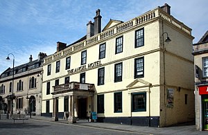
Angel Hotel, Chippenham
Distance: Approx. 746 meters
Latitude and longitude: 51.4577,-2.1146
The Angel Hotel is a grade II* listed hotel in Chippenham, Wiltshire, England. There was an inn called the Bull on this site, on the west side of the town's market place, in 1613; by 1747 it was known as the Angel. The buildings were remodelled and refronted in the early 18th century when the inn expanded into the adjacent house; the frontage has seven bays and three storeys.

Yelde Hall
Municipal building in Chippenham, Wiltshire, England
Distance: Approx. 782 meters
Latitude and longitude: 51.45804,-2.11387
The Yelde Hall is a public facility in the Market Place, in Chippenham, Wiltshire, England. The building, which was the meeting place of Chippenham Borough Council, is a Grade I listed building.
Battle of Chippenham
878 battle between Vikings and Wessex
Distance: Approx. 639 meters
Latitude and longitude: 51.4585,-2.1158
The Battle of Chippenham was a January 878 battle between a Viking army led by Guthrum and an Anglo-Saxon army led by Alfred the Great. The Vikings forced Alfred to flee Chippenham and managed temporarily to gain control over most of Wessex. The battle was part of a coordinated strike on Wessex led by Guthrum and Ubba, breaking an earlier truce between the two sides.

Chippenham Town Hall
Municipal building in Chippenham, Wiltshire, England
Distance: Approx. 617 meters
Latitude and longitude: 51.4586,-2.1161
Chippenham Town Hall is a 19th-century municipal building in the High Street, Chippenham, Wiltshire, England. The town hall, which was the headquarters of Chippenham Borough Council, is a Grade II listed building.

Olympiad Leisure Centre
Leisure centre in Chippenham, England
Distance: Approx. 768 meters
Latitude and longitude: 51.4612,-2.1138
The Olympiad Leisure Centre is a leisure centre in Chippenham, Wiltshire, England.
Weather in this IP's area
broken clouds
6 Celsius
1 Celsius
5 Celsius
6 Celsius
989 hPa
82 %
989 hPa
981 hPa
10000 meters
6.73 m/s
11.24 m/s
270 degree
72 %
