Country:
 Russian Federation
Region:
City:
Latitude and Longitude:
Time Zone:
Postal Code:
IP information under different IP Channel
ip-api
Country
Region
City
ASN
Time Zone
ISP
Blacklist
Proxy
Latitude
Longitude
Postal
Route
IPinfo
Country
Region
City
ASN
Time Zone
ISP
Blacklist
Proxy
Latitude
Longitude
Postal
Route
MaxMind
Country
Region
City
ASN
Time Zone
ISP
Blacklist
Proxy
Latitude
Longitude
Postal
Route
Luminati
Country
RUASN
Time Zone
Europe/Moscow
ISP
Joint Stock Company Gazprom Space Systems
Latitude
Longitude
Postal
db-ip
Country
Region
City
ASN
Time Zone
ISP
Blacklist
Proxy
Latitude
Longitude
Postal
Route
ipdata
Country
Region
City
ASN
Time Zone
ISP
Blacklist
Proxy
Latitude
Longitude
Postal
Route
Popular places and events near this IP address

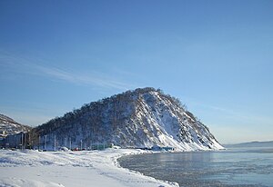
Petropavlovsk-Kamchatsky
City in Kamchatka Krai, Russia
Distance: Approx. 6480 meters
Latitude and longitude: 53.01666667,158.65
Petropavlovsk-Kamchatsky (Russian: Петропавловск-Камчатский, IPA: [pʲɪtrɐˈpavləfsk kɐmˈtɕatskʲɪj] ) is a city and the administrative center of Kamchatka Krai, Russia. It is located in the far east of the country and lies along the coast of Avacha Bay by the Pacific Ocean. As of the 2021 census, it had a population of 164,900.
Avacha (river)
River in Russia
Distance: Approx. 8642 meters
Latitude and longitude: 53.0285,158.5056
Avacha (Russian: Ава́ча) is a river in the southern part of the Kamchatka Peninsula, Russia. It flows southeast into Avacha Bay, near Petropavlovsk-Kamchatsky. The river is 122 kilometres (76 mi) long with a watershed of 5,090 square kilometres (1,970 sq mi).

Siege of Petropavlovsk
Engagement in the Pacific Theatre of the Crimean War
Distance: Approx. 6476 meters
Latitude and longitude: 53.0167,158.65
The siege of Petropavlovsk was a military operation in the Pacific theatre of the Crimean War. The Russian casualties are estimated at 115 soldiers and sailors killed and seriously wounded, whilst the British suffered 105 casualties and the French 104 (by official estimates of the Allies).
Kamchatka State University
Building
Distance: Approx. 5988 meters
Latitude and longitude: 53.02055556,158.64638889
Federal State Budgetary Educational Institution of Higher Education "Kamchatka State University named after Vitus Bering" (Russian: Федеральное государственное бюджетное образовательное учреждение высшего образования «Камчатский государственный университет имени Витуса Беринга») is a higher educational institution in Petropavlovsk-Kamchatsky.
Kamchatka State Technical University
Distance: Approx. 4713 meters
Latitude and longitude: 53.03581,158.65389
Kamchatka State Technical University (Russian: Камчатский государственный технический университет) is a public university located in Petropavlovsk-Kamchatsky, Russia. It was founded in 1942.
Kamchatka Volcanic Eruption Response Team
Volcano research center in Russia
Distance: Approx. 625 meters
Latitude and longitude: 53.06666667,158.6075
The Kamchatka Volcanic Eruption Response Team (KVERT) is a Russian national institution dedicated to provide information of any volcanic activity taking place on the Kamchatka Peninsula and the Kuril Islands of Russia that could become a threat to local communities and aviation. It was established in 1993 by the Far Eastern Branch of the Russian Academy of Sciences, Institute of Volcanic Geology and Seismology (IVS FEB RAS) under cooperation with the Kamchatkan Branch of Geophysical Survey (KBGS RAS). The Alaska Volcano Observatory (AVO), United States Geological Survey (USGS) and its affiliates also provide joint efforts to the program.
Nikolskaya sopka
Mountain in Russia
Distance: Approx. 5922 meters
Latitude and longitude: 53.02027778,158.64222222
Nikolskaya sopka (Russian: Нико́льская со́пка), is a sopka (hill) located in Petropavlovsk-Kamchatsky, Russia, close to the historic centre of the city. Nikolskaya sopka has a rich history, in particular, it was the site of military operations during the Siege of Petropavlovsk in 1854. A natural-historical park is located on the sopka.
Weather in this IP's area
few clouds
10 Celsius
9 Celsius
10 Celsius
10 Celsius
1008 hPa
54 %
1008 hPa
987 hPa
10000 meters
1 m/s
20 %
07:02:37
19:37:47