Country:
 Great Britain
Region:
City:
Latitude and Longitude:
Time Zone:
Postal Code:
IP information under different IP Channel
ip-api
Country
Region
City
ASN
Time Zone
ISP
Blacklist
Proxy
Latitude
Longitude
Postal
Route
IPinfo
Country
Region
City
ASN
Time Zone
ISP
Blacklist
Proxy
Latitude
Longitude
Postal
Route
MaxMind
Country
Region
City
ASN
Time Zone
ISP
Blacklist
Proxy
Latitude
Longitude
Postal
Route
Luminati
Country
GBRegion
eng
City
wandsworth
ASN
Time Zone
Europe/London
ISP
Six Degrees Technology Group Limited
Latitude
Longitude
Postal
db-ip
Country
Region
City
ASN
Time Zone
ISP
Blacklist
Proxy
Latitude
Longitude
Postal
Route
ipdata
Country
Region
City
ASN
Time Zone
ISP
Blacklist
Proxy
Latitude
Longitude
Postal
Route
Popular places and events near this IP address

Putney (UK Parliament constituency)
Parliamentary constituency in the United Kingdom, 1918 onwards
Distance: Approx. 556 meters
Latitude and longitude: 51.454,-0.224
Putney is a constituency in Greater London created in 1918 and represented in the House of Commons of the UK Parliament since 2019 by Fleur Anderson of the Labour Party. Anderson succeeded Justine Greening as Member of Parliament (MP), after Greening announced she would not seek reelection to a fifth term in office. She served as Secretary of State for Transport (2011–2012), Secretary of State for International Development (2012–2016) and Secretary of State for Education (2016–2018) under Prime Ministers David Cameron and Theresa May.

Queen Mary's Hospital, Roehampton
Hospital in Roehampton, England, United Kingdom
Distance: Approx. 730 meters
Latitude and longitude: 51.4553,-0.2422
Queen Mary's Hospital, formerly Queen Mary's Convalescent Auxiliary Hospitals, is a community hospital in Roehampton in the London Borough of Wandsworth. It is run by St George's University Hospitals NHS Foundation Trust.

Elliott School, Putney
Comprehensive school in London, England
Distance: Approx. 441 meters
Latitude and longitude: 51.4548,-0.2259
Elliott School was a school in Putney, England, founded in 1904, which became the Ark Putney Academy in 2012.
Scio House Hospital
Distance: Approx. 724 meters
Latitude and longitude: 51.4472,-0.2322
Scio House Hospital for Officers was a hospital catering for military officers in Putney, London.
Ark Putney Academy
Academy in Putney Heath, Putney, London, England
Distance: Approx. 489 meters
Latitude and longitude: 51.454892,-0.2252125
Ark Putney Academy (formerly Elliott School) is a co-educational secondary school and sixth form with academy status, located in the Putney Heath area of the London Borough of Wandsworth, England.
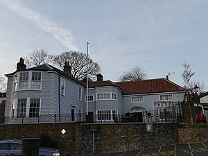
King's Head, Roehampton
Pub in Roehampton, London
Distance: Approx. 717 meters
Latitude and longitude: 51.450283,-0.240766
The King's Head is a Grade II listed public house at 1 Roehampton High Street, Roehampton, London SW15 4HL. It dates back to the 17th century, although altered and extended since then.

Montague Arms
Former pub in Roehampton, London
Distance: Approx. 699 meters
Latitude and longitude: 51.44995,-0.240088
The Montague Arms is a Grade II listed building at 3 Medfield Street, Roehampton, London. Previously a public house, it dates to the 17th century, although has been altered since. The pub was closed in 2006 and converted to offices, and later became an off licence shop by the name of Lloyds local.
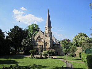
Holy Trinity, Roehampton
Distance: Approx. 616 meters
Latitude and longitude: 51.449204,-0.237166
Holy Trinity is the Church of England parish church for Roehampton, located in Ponsonby Road, SW15 4LA. Morning and Evening Prayer are said and sung daily in the church except Saturdays, 8.30 and 5.30. The main weekly service is 10am on Sunday. All are welcome.
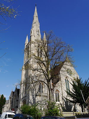
St Margaret's Church, Putney
Church in London, England
Distance: Approx. 624 meters
Latitude and longitude: 51.4591,-0.234439
St Margaret's, Putney is situated in Putney Park Lane, Putney, London, England. It was designed by W. Allen Dixon in 1872. Prior to its dedication to St Margaret as an Anglican church it was first a Baptist and then a Presbyterian chapel under the name of Granard Chapel.
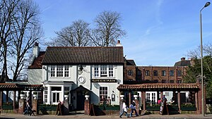
Green Man, Putney
Distance: Approx. 570 meters
Latitude and longitude: 51.45343611,-0.22379444
The Green Man is a public house in Putney in the London Borough of Wandsworth, on the edge of Putney Heath, parts of which date back to around 1700. The pub was once frequented by highwaymen and was a popular place for participants to fortify themselves before or after a duel on nearby Putney Heath.

Drinking Fountain, Roehampton
Sculptural monument by J. C. Radford
Distance: Approx. 701 meters
Latitude and longitude: 51.449666,-0.239754
The Drinking Fountain is a Grade II-listed monument at Roehampton Lane, Roehampton, London SW15. It was built in 1882, and designed by J. C. Radford.

Wildcroft Manor
Historic site in London, England
Distance: Approx. 605 meters
Latitude and longitude: 51.4484872,-0.2295479
Wildcroft Manor is a historic site in Putney in the London Borough of Wandsworth, with private housing and a Grade II Listed iron gateway.
Weather in this IP's area
broken clouds
15 Celsius
15 Celsius
14 Celsius
16 Celsius
1018 hPa
89 %
1018 hPa
1013 hPa
10000 meters
3.09 m/s
30 degree
75 %
06:45:54
19:01:58