Country:
 Italy
ItalyRegion:
City:
Latitude and Longitude:
Time Zone:
Postal Code:
IP information under different IP Channel
ip-api
Country
Region
City
ASN
Time Zone
ISP
Blacklist
Proxy
Latitude
Longitude
Postal
Route
IPinfo
Country
Region
City
ASN
Time Zone
ISP
Blacklist
Proxy
Latitude
Longitude
Postal
Route
MaxMind
Country
Region
City
ASN
Time Zone
ISP
Blacklist
Proxy
Latitude
Longitude
Postal
Route
Luminati
Country
ITASN
Time Zone
Europe/Rome
ISP
SEEWEB s.r.l.
Latitude
Longitude
Postal
db-ip
Country
Region
City
ASN
Time Zone
ISP
Blacklist
Proxy
Latitude
Longitude
Postal
Route
ipdata
Country
Region
City
ASN
Time Zone
ISP
Blacklist
Proxy
Latitude
Longitude
Postal
Route
Popular places and events near this IP address

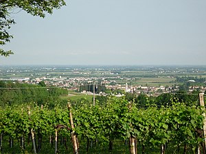
Conegliano
Comune in Veneto, Italy
Distance: Approx. 685 meters
Latitude and longitude: 45.88675556,12.29738889
Conegliano (Italian: [koneʎˈʎaːno]; Venetian: Conejan) is a town and comune of the Veneto region, Italy, in the province of Treviso, about 30 kilometres (19 mi) north by rail from the town of Treviso. The population of the city is of 35,023 people. The remains of a 10th-century castle are situated on a hill that dominates the town.

Santa Lucia di Piave
Comune in Veneto, Italy
Distance: Approx. 4892 meters
Latitude and longitude: 45.85,12.28333333
Santa Lucia di Piave is a comune in the province of Treviso, Veneto, north-eastern Italy.

Colle Umberto
Comune in Veneto, Italy
Distance: Approx. 7566 meters
Latitude and longitude: 45.95,12.35
Colle Umberto (Venetian: Cołe Unberto) is a comune (municipality) in the Province of Treviso in the Italian region Veneto, located about 60 kilometres (37 mi) north of Venice and about 30 kilometres (19 mi) north of Treviso. Colle Umberto borders the following municipalities: Cappella Maggiore, Conegliano, Cordignano, Godega di Sant'Urbano, San Fior, Vittorio Veneto. The town's most visited place is the Villa Verecondi Scortecci owned by an old upper-class Venetian family.
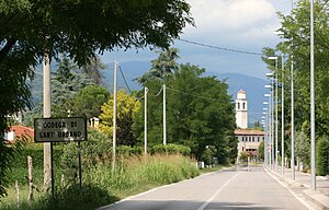
Godega di Sant'Urbano
Comune in Veneto, Italy
Distance: Approx. 9160 meters
Latitude and longitude: 45.93333333,12.4
Godega di Sant'Urbano (Italian: [ˈɡoːdeɡa di santurˈbaːno]), also known simply as Godega (Venetian: Gódega [ˈɡodeɡa]), is a comune (municipality) in the province of Treviso, in the Italian region of Veneto, located about 60 kilometres (37 mi) north of Venice and about 30 kilometres (19 mi) northeast of Treviso. Godega di Sant'Urbano borders the following municipalities: Codogné, Colle Umberto, Cordignano, Gaiarine, Orsago, San Fior.

Mareno di Piave
Comune in Veneto, Italy
Distance: Approx. 6299 meters
Latitude and longitude: 45.85,12.35
Mareno di Piave is a comune (municipality) in the Province of Treviso in the Italian region Veneto, located about 45 kilometres (28 mi) north of Venice and about 20 kilometres (12 mi) northeast of Treviso. Mareno di Piave borders the following municipalities: Cimadolmo, Codogné, Conegliano, San Vendemiano, Santa Lucia di Piave, Spresiano, Vazzola.
Nervesa della Battaglia
Comune in Veneto, Italy
Distance: Approx. 9097 meters
Latitude and longitude: 45.83333333,12.21666667
Nervesa della Battaglia is a comune (municipality) in the Province of Treviso in the Italian region Veneto, located about 45 kilometres (28 mi) north of Venice and about 20 kilometres (12 mi) north of Treviso. In February 1358 Nervesa was the scene of a battle in which the Republic of Venice was defeated by the forces of King Louis I of Hungary. That defeat forced the Venetians to sign the highly unfavorable Treaty of Zadar.
San Fior
Comune in Veneto, Italy
Distance: Approx. 6735 meters
Latitude and longitude: 45.9,12.38333333
San Fior is a comune (municipality) in the Province of Treviso in the Italian region Veneto, located about 50 kilometres (31 mi) north of Venice and about 30 kilometres (19 mi) northeast of Treviso. As of 31 December 2004, it had a population of 6,357 and an area of 17.8 square kilometres (6.9 sq mi). San Fior borders the following municipalities: Codogné, Colle Umberto, Conegliano, Godega di Sant'Urbano, San Vendemiano.
Susegana
Comune in Veneto, Italy
Distance: Approx. 6006 meters
Latitude and longitude: 45.85,12.25
Susegana is a comune (municipality) in the Province of Treviso in the Italian region Veneto, located about 45 km (28 mi) north of Venice and about 20 km (12 mi) north of Treviso.
Castello Roganzuolo
Frazione in Veneto, Italy
Distance: Approx. 3863 meters
Latitude and longitude: 45.91666667,12.33333333
Castello Roganzuolo (Castél in Venetian language) is a frazione of San Fior comune (municipality) in the Province of Treviso in the Italian region Veneto, located on Conegliano hills (famous for productions of wine, especially prosecco) about 50 km north of Venice and about 30 km northeast of Treviso.

Conegliano railway station
Railway station in Veneto, Italy
Distance: Approx. 919 meters
Latitude and longitude: 45.88472222,12.29861111
Conegliano (Italian: Stazione di Conegliano) is a railway station serving the town of Conegliano, in the region of Veneto, northern Italy. The station opened on 1 May 1855 and is located on the Venice–Udine railway and Ponte nelle Alpi-Conegliano railway. The train services are operated by Trenitalia.

Collalto, Susegana
Village in Treviso, Italy
Distance: Approx. 8012 meters
Latitude and longitude: 45.8717,12.1982
Collalto is a village in the province of Treviso in northern Italy, forming a 'frazione' or part of the municipality of Susegana.
Col di Manza
Hill in Treviso, Italy
Distance: Approx. 4634 meters
Latitude and longitude: 45.9282,12.3287
Col di Manza (Venetian language - Col de Manzha) is a hill between the towns of Colle Umberto and San Fior in the province of Treviso in Italy, facing the higher hill of Castello Roganzuolo. It is notable as the site of a villa built for the painter Titian.
Weather in this IP's area
light rain
16 Celsius
16 Celsius
15 Celsius
17 Celsius
1019 hPa
99 %
1019 hPa
1008 hPa
7360 meters
1.59 m/s
4.03 m/s
58 degree
100 %
07:33:05
18:18:02