Country:
 Italy
ItalyRegion:
City:
Latitude and Longitude:
Time Zone:
Postal Code:
IP information under different IP Channel
ip-api
Country
Region
City
ASN
Time Zone
ISP
Blacklist
Proxy
Latitude
Longitude
Postal
Route
IPinfo
Country
Region
City
ASN
Time Zone
ISP
Blacklist
Proxy
Latitude
Longitude
Postal
Route
MaxMind
Country
Region
City
ASN
Time Zone
ISP
Blacklist
Proxy
Latitude
Longitude
Postal
Route
Luminati
Country
ITASN
Time Zone
Europe/Rome
ISP
SEEWEB s.r.l.
Latitude
Longitude
Postal
db-ip
Country
Region
City
ASN
Time Zone
ISP
Blacklist
Proxy
Latitude
Longitude
Postal
Route
ipdata
Country
Region
City
ASN
Time Zone
ISP
Blacklist
Proxy
Latitude
Longitude
Postal
Route
Popular places and events near this IP address

Province of Treviso
Province of Italy
Distance: Approx. 7920 meters
Latitude and longitude: 45.67222222,12.24222222
The province of Treviso (Italian: provincia di Treviso) is a province in the Veneto region of Italy. Its capital is the city of Treviso. The province is surrounded by Belluno in the north, Vicenza in the west, Padua in southwest, Venice in the south-east and Friuli-Venezia Giulia in the east.
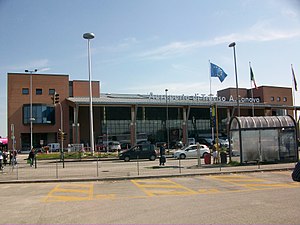
Treviso Airport
Airport in Treviso, Italy
Distance: Approx. 4269 meters
Latitude and longitude: 45.65083333,12.19777778
Treviso Airport, Italian: Aeroporto di Treviso A. Canova (IATA: TSF, ICAO: LIPH), sometimes Venice-Treviso Airport, is an international airport located 1.6 NM (3.0 km; 1.8 mi) west-southwest of Treviso and approximately 31 km (19 mi) away from the city of Venice, Italy. It is used mainly by low-cost airlines. Some airlines refer to the airport unofficially as "Venice-Treviso" or similar.
Istrana
Comune in Veneto, Italy
Distance: Approx. 4584 meters
Latitude and longitude: 45.68333333,12.1
Istrana is a comune (municipality) in the Province of Treviso in the Italian region Veneto, located about 35 kilometres (22 mi) northwest of Venice and about 12 kilometres (7 mi) west of Treviso. As of 31 December 2022, it had a population of 9,141 and an area of 26.3 square kilometres (10.2 sq mi). The municipality of Istrana contains the frazioni (subdivisions, mainly villages and hamlets) Sala, Pezzan, Ospedaletto, Villanova, the Istrana Air Base.

Morgano
Comune in Veneto, Italy
Distance: Approx. 3423 meters
Latitude and longitude: 45.65,12.1
Morgano is a comune (municipality) in the Province of Treviso in the Italian region Veneto, located about 30 kilometres (19 mi) northwest of Venice and about 12 kilometres (7 mi) west of Treviso. Morgano borders the following municipalities: Istrana, Paese, Piombino Dese, Quinto di Treviso, Zero Branco.
Paese
Comune in Veneto, Italy
Distance: Approx. 1358 meters
Latitude and longitude: 45.66666667,12.15
Paese (Venetian: Paexe)is a comune (municipality) in the Province of Treviso in the Italian region Veneto, located about 30 kilometres (19 mi) northwest of Venice and about 8 kilometres (5 mi) west of Treviso. As of 31 December 2004, it had a population of 19,898 and an area of 38.0 square kilometres (14.7 sq mi). “Paese” in Italian literally means “Village”.

Stadio Comunale di Monigo
Rugby union stadium in Treviso, Italy
Distance: Approx. 6103 meters
Latitude and longitude: 45.6803,12.2132
Stadio Comunale di Monigo is a sports stadium in the Treviso frazione of Monigo, Italy. The stadium is used for rugby union, and is the home ground for Benetton. The stadium has a total capacity of 5,000, divided between the two covered stands: the Tribuna Ovest (West Stand), seated with 2,700 seats, and the Tribuna Est (East Stand), seated with 2,300 seats.

Treviso Centrale railway station
Railway station in Italy
Distance: Approx. 7908 meters
Latitude and longitude: 45.66,12.24472222
Treviso Centrale railway station (Italian: Stazione di Treviso Centrale) serves the city and comune of Treviso, in the Veneto region, northeastern Italy. Opened in 1851, the station forms part of the Venice–Udine railway, and is also a junction of three branch lines, to Montebelluna (and from there to Belluno and Calalzo along the Calalzo-Padova railway), Vicenza and Portogruaro, respectively. Although Treviso Centrale is currently the only railway station in Treviso, it is so named to distinguish it from the two other railway facilities within the comune boundaries: Treviso Porta Santi Quaranta (a goods yard) and the marshalling yard at Treviso Scalo Motta.
Treviso Cathedral
Distance: Approx. 7836 meters
Latitude and longitude: 45.66638889,12.24277778
Treviso Cathedral (Italian: Duomo di Treviso, Cattedrale di San Pietro Apostolo) is a Roman Catholic cathedral in Treviso, Veneto, northern Italy, dedicated to Saint Peter. It is the seat of the bishop of Treviso.
Istrana Air Base
Airport in Istrana
Distance: Approx. 5729 meters
Latitude and longitude: 45.685,12.08305556
Istrana Air Base (ICAO: LIPS) is a military airport located in Istrana, Veneto, Italy. It is home to the Italian Air Force's 51º Stormo.

Monigo concentration camp
Italian concentration camp
Distance: Approx. 5804 meters
Latitude and longitude: 45.6816,12.2078
The Monigo concentration camp was a prison camp opened during World War II aimed at civilian prisoners (mostly Slovenes and Croats). It was located in Monigo, a suburb of the town of Treviso. The camp was active between 1942 and 1943.

Piazza dei Signori, Treviso
Distance: Approx. 8037 meters
Latitude and longitude: 45.665894,12.245501
Piazza dei Signori is a city square in Treviso, north-eastern Italy. It takes its name (meaning "Lords Square" in Italian) from the palaces of lords the former seignory of Treviso which face it. They include: Palazzo del Podestà with the Civic tower (13th century), which was the lordship's seat Palazzo dei Trecento Palazzo Pretorio (with a 17th century façade) Original seat of the Municipal Library and the Municipal Gallery (1847) The Square also features several sculptures of Lion of Saint Mark, a symbol of the former domination of the Republic of Venice on Treviso.

Fontana Delle Tette
Fountain in Treviso, Italy
Distance: Approx. 8005 meters
Latitude and longitude: 45.6663,12.245
The Fountana de łe tete is an old fountain in Treviso, Italy. Under the Venetian Republic it poured white and red wine during special celebrations. The name translates into English as "The Fountain of Tits" and is usually translated in Italian as "Fontana delle tette".
Weather in this IP's area
heavy intensity rain
22 Celsius
22 Celsius
21 Celsius
23 Celsius
1010 hPa
89 %
1010 hPa
1008 hPa
8000 meters
4.63 m/s
90 degree
40 %
06:41:36
19:36:48