Country:
 Romania
Region:
City:
Latitude and Longitude:
Time Zone:
Postal Code:
IP information under different IP Channel
ip-api
Country
Region
City
ASN
Time Zone
ISP
Blacklist
Proxy
Latitude
Longitude
Postal
Route
IPinfo
Country
Region
City
ASN
Time Zone
ISP
Blacklist
Proxy
Latitude
Longitude
Postal
Route
MaxMind
Country
Region
City
ASN
Time Zone
ISP
Blacklist
Proxy
Latitude
Longitude
Postal
Route
Luminati
Country
ROASN
Time Zone
Europe/Bucharest
ISP
Softwin SRL
Latitude
Longitude
Postal
db-ip
Country
Region
City
ASN
Time Zone
ISP
Blacklist
Proxy
Latitude
Longitude
Postal
Route
ipdata
Country
Region
City
ASN
Time Zone
ISP
Blacklist
Proxy
Latitude
Longitude
Postal
Route
Popular places and events near this IP address

Pipera metro station
Bucharest metro station
Distance: Approx. 456 meters
Latitude and longitude: 44.4806,26.1165
Pipera is a metro station in Bucharest, located in the Pipera district. Opened on 24 October 1987 as part of the M2 extension from Piața Unirii, it is the northern terminus of the line. The initial scope of the station was to serve the large Pipera industrial estate.
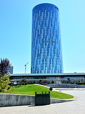
Floreasca City Center
Skyscraper in Bucharest
Distance: Approx. 1489 meters
Latitude and longitude: 44.47833333,26.10388889
Floreasca City Center is a multi-functional center with a shopping and entertainment complex as well as two office buildings in Bucharest. Floreasca City Center consists of a center for shopping, entertainment and business. The gross area amounts to approx.
Valea Saulei
River in Bucharest, Romania
Distance: Approx. 1106 meters
Latitude and longitude: 44.4759,26.1336
The Valea Saulei is a left tributary of the river Colentina in Romania. It flows into the Colentina in Bucharest. Its length is 6 km (3.7 mi) and its basin size is 50 km2 (19 sq mi).
UpGround
Distance: Approx. 614 meters
Latitude and longitude: 44.479728,26.114781
UpGround is a condominium located in Bucharest at the intersection of Barbu Văcărescu and Fabrica de Glucoză streets and Şoseaua Petricani. The project consists of four buildings, two residential and two office with a total floor area of 226,000 square metres (2,430,000 sq ft). The two residential buildings have 16 floors each and include a number of 600 apartments and have a floor area of 126,000 m2 (1,360,000 sq ft).

Pipera Airport
Airport in Bucharest, Romania
Distance: Approx. 953 meters
Latitude and longitude: 44.47805556,26.11111111
Bucharest Pipera Airfield was located in the Pipera neighborhood of Bucharest, Romania, at the northern edge of the city, right next to the town of Voluntari, Ilfov County. The airport no longer exists. A small military base, which also hosts the National Museum of Romanian Aviation, remains in the location where the airport used to be.

Globalworth Tower
Skyscraper in Bucharest
Distance: Approx. 1739 meters
Latitude and longitude: 44.4794,26.1004
Globalworth Tower, known previously as Bucharest One, is a class A office building that is located in the northern part of Bucharest, Romania, in the vicinity of Calea Floreasca, Barbu Văcărescu Boulevard and Pipera. The building has a total of 26 floors and a gross leasable area of 54,700 m2 (589,000 sq ft). The 118 m (387 ft) high building is the second tallest in Bucharest and Romania just under the 137 m (449 ft) Floreasca City Center's Sky Tower.
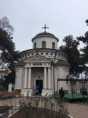
Teiul Doamnei Ghica Church
Orthodox church in Bucharest, Romania
Distance: Approx. 1711 meters
Latitude and longitude: 44.4668,26.12838
The Teiul Doamnei Ghica Church (Romanian: Biserica Teiul Doamnei Ghica, lit. “Lady Ghica’s linden tree”) is a Romanian Orthodox church located at 3 Doamna Ghica Street in Bucharest, Romania. It is dedicated to the Feast of the Ascension.

Plumbuita Monastery
Heritage site in Bucharest, Romania
Distance: Approx. 1459 meters
Latitude and longitude: 44.472288,26.135172
The Plumbuita Monastery (Romanian: Mănăstirea Plumbuita) is a Romanian Orthodox monastery located at 58 Plumbuita Street in Bucharest, Romania. Its church is dedicated to Saint John the Baptist.

Lake Floreasca
Reservoir in Sector , Bucharest
Distance: Approx. 1684 meters
Latitude and longitude: 44.4710452,26.1067771
Lake Floreasca is an anthropic lake located in the northern part of the city of Bucharest, developed on the Colentina River, in the area where it flows through the urban area of the city, situated between Lake Herăstrău upstream and Lake Tei downstream.
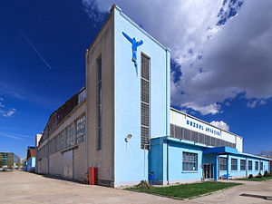
National Museum of Romanian Aviation
Museum in Bucharest, Romania
Distance: Approx. 1033 meters
Latitude and longitude: 44.47693889,26.11076944
The National Museum of Romanian Aviation (Romanian: Muzeul Național al Aviației Române) is an aviation museum owned by the General Staff of the Romanian Air Force. The museum was established on 2 March 1990, being initially located on the Otopeni military base. In 2006, it was moved in the hangars of the former Pipera Airport.
Promenada Mall (Bucharest)
Building in Bucharest, Romania
Distance: Approx. 1549 meters
Latitude and longitude: 44.4780597,26.1031979
Promenada Mall Bucharest is a shopping center located in Romania. It was developed by investment firm Raiffeisen Evolution and inaugurated on 17 October 2013, after a 130 million euro investment. Promenada is the first mall opened in bucharest after the financial crisis in 2007–2009, construction began in January 2012 and lasted 22 months.
Embassy of the Philippines, Bucharest
Diplomatic mission of the Philippines in Romania
Distance: Approx. 1697 meters
Latitude and longitude: 44.47769444,26.10141667
The Embassy of the Philippines in Bucharest is the diplomatic mission of the Republic of the Philippines to Romania. It is located in the neighborhood of Aviației, part of Sector 1 in northern Bucharest, near the Floreasca City Center skyscraper. Although the current embassy dates from 2024, the Philippines also maintained a previous resident embassy in Romania between 1975 and 2012.
Weather in this IP's area
clear sky
11 Celsius
10 Celsius
10 Celsius
11 Celsius
1030 hPa
59 %
1030 hPa
1019 hPa
10000 meters
3.6 m/s
80 degree
07:35:48
18:24:44