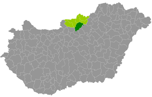
Country:
Region:
City:
Latitude and Longitude:
Time Zone:
Postal Code:
IP information under different IP Channel
ip-api
Country
Region
City
ASN
Time Zone
ISP
Blacklist
Proxy
Latitude
Longitude
Postal
Route
Luminati
Country
Region
no
City
bujak
ASN
Time Zone
Europe/Budapest
ISP
Invitech ICT Services Kft.
Latitude
Longitude
Postal
IPinfo
Country
Region
City
ASN
Time Zone
ISP
Blacklist
Proxy
Latitude
Longitude
Postal
Route
db-ip
Country
Region
City
ASN
Time Zone
ISP
Blacklist
Proxy
Latitude
Longitude
Postal
Route
ipdata
Country
Region
City
ASN
Time Zone
ISP
Blacklist
Proxy
Latitude
Longitude
Postal
Route
Popular places and events near this IP address

Cserhát
Mountain range in Hungary
Distance: Approx. 4719 meters
Latitude and longitude: 47.91666667,19.5
Cserhát ([ˈtʃɛrhaːt]) is a mountain range in Hungary, part of the North Hungarian Mountains, divided between Pest and Nógrád counties. Its highest point is the Karancs with an elevation of 729 metres above sea level. Cserhát stretches from Cserhátalja to the valley of the Ipoly (Slovak: Ipeľ) river.

Bokor, Hungary
Village in Nógrád, Hungary
Distance: Approx. 5284 meters
Latitude and longitude: 47.92943,19.54201
Bokor is a village in Nógrád county, Hungary.

Ecseg
Place in Nógrád, Hungary
Distance: Approx. 5309 meters
Latitude and longitude: 47.89708,19.60412
Ecseg is a village in Nógrád county, Hungary.

Szanda
Place in Nógrád, Hungary
Distance: Approx. 8861 meters
Latitude and longitude: 47.92689,19.43844
Szanda is a village in Nógrád county, Hungary.

Bér
Village and municipality in Nógrád, Hungary
Distance: Approx. 3228 meters
Latitude and longitude: 47.86666667,19.5
Bér is a village and municipality in the comitat of Nógrád, Hungary. The village is the part of the Novohrad-Nógrád Geopark.

Buják
Municipality in Nógrád, Hungary
Distance: Approx. 1010 meters
Latitude and longitude: 47.88333333,19.55
Buják is a village and municipality in the Pásztó District of Nógrád County, Hungary.
Cserhátszentiván
Village and Municipality in Northern Hungary, Hungary
Distance: Approx. 6685 meters
Latitude and longitude: 47.93333333,19.58333333
Cserhátszentiván is a village and municipality in the comitat of Nógrád, Hungary.
Csécse
Village in Nógrád, Hungary
Distance: Approx. 7424 meters
Latitude and longitude: 47.86666667,19.63333333
Csécse is a village and municipality in the comitat of Nógrád, Hungary.

Kisbágyon
Village in Nógrád County, Hungary
Distance: Approx. 8077 meters
Latitude and longitude: 47.81666667,19.58333333
Kisbágyon is a village in Nógrád County, Hungary with 417 inhabitants (2014).

Kozárd
Village in Nógrád County, Hungary
Distance: Approx. 6300 meters
Latitude and longitude: 47.9,19.61666667
Kozárd is a village in Nógrád County, Hungary with 162 inhabitants as of 2022.
Kutasó
Village in Nógrád County, Hungary
Distance: Approx. 5708 meters
Latitude and longitude: 47.93333333,19.53333333
Kutasó is a village in Pásztó District, Nógrád County, Hungary with 87 inhabitants (2014).

Pásztó District
Districts of Hungary in Nógrád
Distance: Approx. 6222 meters
Latitude and longitude: 47.8667,19.6167
Pásztó (Hungarian: Pásztói járás) is a district in south-eastern part of Nógrád County. Pásztó is also the name of the town where the district seat is found. The district is located in the Northern Hungary Statistical Region.
Weather in this IP's area
broken clouds
-0 Celsius
-3 Celsius
-0 Celsius
-0 Celsius
1014 hPa
80 %
1014 hPa
988 hPa
10000 meters
1.77 m/s
3.51 m/s
250 degree
59 %
06:52:47
16:01:41

