Country:
 Russian Federation
Region:
City:
Latitude and Longitude:
Time Zone:
Postal Code:
IP information under different IP Channel
ip-api
Country
Region
City
ASN
Time Zone
ISP
Blacklist
Proxy
Latitude
Longitude
Postal
Route
IPinfo
Country
Region
City
ASN
Time Zone
ISP
Blacklist
Proxy
Latitude
Longitude
Postal
Route
MaxMind
Country
Region
City
ASN
Time Zone
ISP
Blacklist
Proxy
Latitude
Longitude
Postal
Route
Luminati
Country
RUASN
Time Zone
Europe/Moscow
ISP
Rostelecom
Latitude
Longitude
Postal
db-ip
Country
Region
City
ASN
Time Zone
ISP
Blacklist
Proxy
Latitude
Longitude
Postal
Route
ipdata
Country
Region
City
ASN
Time Zone
ISP
Blacklist
Proxy
Latitude
Longitude
Postal
Route
Popular places and events near this IP address
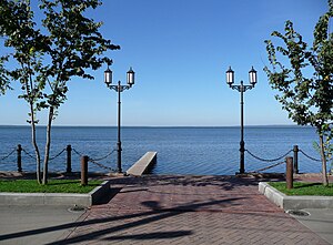
Lake Pleshcheyevo
Glacial lake in Yaroslavl Oblast, Russia
Distance: Approx. 6811 meters
Latitude and longitude: 56.76638889,38.78444444
Lake Pleshcheyevo (Russian: Плеще́ево о́зеро, IPA: [plʲɪˈɕːejɪvə ˈozʲɪrə]) is a glacial lake in Yaroslavl Oblast, Russia. The historic town of Pereslavl-Zalessky is on the southeastern side of the lake. The lake, which is part of Pleshcheyevo Ozero National Park, covers an area of over 51 km2, its length being 9.5 kilometres (5.9 mi) and its shoreline 28 kilometres (17 mi).

Trubezh
River in Russia
Distance: Approx. 3879 meters
Latitude and longitude: 56.7345,38.831
The Trubezh (Russian: Трубеж) is a river in Yaroslavl Oblast, Russia. It flows to the Lake Pleshcheyevo. Major city: Pereslavl-Zalessky.
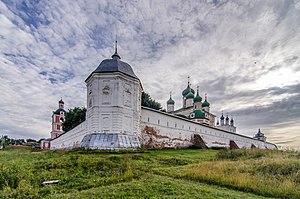
Goritsky Monastery (Pereslavl-Zalessky)
Russian Monastery
Distance: Approx. 5008 meters
Latitude and longitude: 56.7206,38.8239
The Goritsky Monastery of Dormition (Russian: Успенский Горицкий монастырь) was a Russian Orthodox monastery in Pereslavl-Zalessky, Russia. It was supposedly established in the early 14th century during the reign of Ivan I of Moscow (Ivan Kalita). In 1382 Tokhtamysh Khan destroyed the town and the monastery with it.

Blue Stone (Russia)
Russian sacred stone
Distance: Approx. 5779 meters
Latitude and longitude: 56.78416667,38.82416667
Blue Stone, or Blue Rock (Russian: Синь-камень) is a type of pagan sacred stones, widespread in Russia in areas historically inhabited by both Eastern Slavic (Russian), and Volga Finnic tribes (Merya, Muroma). Unlike Sledovik (both Sledovik proper and Cup-stones), Blue Stones did not have major hallows on them, and were venerated in a simpler way: by pouring water on them, or leaving food offerings. Some of the Blue Stones are still known, and to some extent venerated by local populations.

Pereslavl-Zalessky
Town in Yaroslavl Oblast, Russia
Distance: Approx. 2893 meters
Latitude and longitude: 56.73333333,38.85
Pereslavl-Zalessky (Russian: Переславль-Залесский, IPA: [pʲɪrʲɪˈslavlʲ zɐˈlʲeskʲɪj]), formerly known as Pereyaslavl-Zalessky, is a town in Yaroslavl Oblast, Russia, located on the main Moscow–Yaroslavl road and on the southeastern shore of Lake Pleshcheyevo at the mouth of the Trubezh River. Population: 41,925 (2010 Census); 43,379 (2002 Census); 42,331 (1989 Soviet census).

Pereslavsky District
District in Yaroslavl Oblast, Russia
Distance: Approx. 2893 meters
Latitude and longitude: 56.73333333,38.85
Pereslavsky District (Russian: Пересла́вский райо́н) is an administrative and municipal district (raion), one of the seventeen in Yaroslavl Oblast, Russia. It is located in the south of the oblast. The area of the district is 3,130 square kilometers (1,210 sq mi).

St. Nicholas Monastery (Pereslavl-Zalessky)
Distance: Approx. 3658 meters
Latitude and longitude: 56.732,38.837
The St. Nicholas Monastery (or Nikolsky Monastery) is a Russian Orthodox monastery in Pereslavl-Zalessky, Russia.
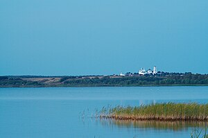
Pleshcheyevo Ozero National Park
National park in Russia
Distance: Approx. 9826 meters
Latitude and longitude: 56.76666667,38.73333333
Pleshcheyovo Ozero (Lake) National Park (Russian: Национальный парк «Плещеево озеро») covers Lake Pleshcheyevo and surrounding areas in the Zalesye part of the Yaroslavl Oblast. The lake is highly popular for recreational use, as an ecological habitat, and is a former resort for the Russian tsars. The lake is located on the central part of the East European Plain, about 130 km northeast of Moscow, in the basin of the Upper Volga.

Nikitsky Monastery
Distance: Approx. 2406 meters
Latitude and longitude: 56.76083333,38.86
The Nikitsky Monastery (Никитский монастырь) is a walled Orthodox monastery founded in the 12th century by Nicetas (Nikita) Stylites in a field sprawling between the Kholmogory Highway and the Lake Pleshcheyevo several miles north of Pereslavl-Zalessky. It is part of the Pleshcheyevo Lake National Park and one of the oldest monastic establishments in Zalesye. The monastic compound is separated from the town by a wooded cemetery with a round chapel from 1702.

Kleshchin
Former town in Pereslavsky District, Yaroslavl Oblast, Russia
Distance: Approx. 4509 meters
Latitude and longitude: 56.77639,38.83944
Kleshchin (Клещин) was a Meryan (and later Slavic) town on the eastern shore of Lake Pleshcheyevo in Zalesye. It is thought that the lake owes its name to the derelict town: the opening lines of the Primary Chronicle refer to the lake as Kleshchino (or Kleshcheyevo). In 1152, Grand Duke George I of Vladimir had Kleshchin transferred 4500 meters to the south, renaming it Pereslavl-Beyond-the-Woods.
Weather in this IP's area
overcast clouds
7 Celsius
5 Celsius
7 Celsius
7 Celsius
1032 hPa
65 %
1032 hPa
1010 hPa
10000 meters
2.36 m/s
3.27 m/s
324 degree
89 %
07:05:50
17:12:34