Country:
 Great Britain
Region:
City:
Latitude and Longitude:
Time Zone:
Postal Code:
IP information under different IP Channel
ip-api
Country
Region
City
ASN
Time Zone
ISP
Blacklist
Proxy
Latitude
Longitude
Postal
Route
IPinfo
Country
Region
City
ASN
Time Zone
ISP
Blacklist
Proxy
Latitude
Longitude
Postal
Route
MaxMind
Country
Region
City
ASN
Time Zone
ISP
Blacklist
Proxy
Latitude
Longitude
Postal
Route
Luminati
Country
GBRegion
eng
City
kingstonuponthames
ASN
Time Zone
Europe/London
ISP
Infinity Developments Limited
Latitude
Longitude
Postal
db-ip
Country
Region
City
ASN
Time Zone
ISP
Blacklist
Proxy
Latitude
Longitude
Postal
Route
ipdata
Country
Region
City
ASN
Time Zone
ISP
Blacklist
Proxy
Latitude
Longitude
Postal
Route
Popular places and events near this IP address

Wallsend
Town in North Tyneside, England
Distance: Approx. 11 meters
Latitude and longitude: 54.991,-1.534
Wallsend () is a town in North Tyneside, Tyne and Wear, England, at the eastern end of Hadrian's Wall. It has a population of 43,842 and lies 4 miles (6.5 kilometres) east of Newcastle upon Tyne.

Swan Hunter
Shipbuilding company based in England
Distance: Approx. 595 meters
Latitude and longitude: 54.98675,-1.52856
Swan Hunter, formerly known as Swan Hunter & Wigham Richardson, is a shipbuilding design, engineering, and management company, based in Wallsend, Tyne and Wear, England. At its apex, the company represented the combined forces of three powerful shipbuilding families: Swan, Hunter and Wigham Richardson. The company was responsible for some of the greatest ships of the early 20th century, most famously RMS Mauretania which held the Blue Riband for the fastest crossing of the Atlantic, and RMS Carpathia which rescued survivors from RMS Titanic.

Newcastle upon Tyne East and Wallsend (UK Parliament constituency)
Parliamentary constituency in the United Kingdom, 1997–2010 & 2024 onwards
Distance: Approx. 404 meters
Latitude and longitude: 54.99,-1.54
Newcastle upon Tyne East and Wallsend is a constituency represented in the House of Commons of the Parliament of the United Kingdom. It elects one Member of Parliament (MP) by the first past the post system of election. This constituency was created in 1997, abolished in 2010, then re-established under the 2023 Periodic Review of Westminster constituencies for the 2024 general election.

Segedunum
Roman fort in Tyne and Wear, England
Distance: Approx. 371 meters
Latitude and longitude: 54.98791,-1.53231
Segedunum was a Roman fort at modern-day Wallsend, North Tyneside in North East England. The fort lay at the eastern end of Hadrian's Wall near the banks of the River Tyne. It was in use for approximately 300 years from around 122 AD to almost 400.
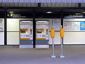
Wallsend Metro station
Tyne and Wear Metro station in North Tyneside
Distance: Approx. 185 meters
Latitude and longitude: 54.9895984,-1.5327361
Wallsend is a Tyne and Wear Metro station, serving the town of Wallsend, North Tyneside in Tyne and Wear, England. It joined the network on 14 November 1982, following the opening of the fourth phase of the network, between Tynemouth and St James via Wallsend.
Wallsend (UK Parliament constituency)
Parliamentary constituency in the United Kingdom, 1918–1997
Distance: Approx. 63 meters
Latitude and longitude: 54.991,-1.533
Wallsend was a parliamentary constituency centred on Wallsend, a town on the north bank of the River Tyne in North Tyneside. It returned one Member of Parliament (MP) to the House of Commons of the Parliament of the United Kingdom from 1918 to 1997.

Carville power stations
Two coal-fired power stations in England
Distance: Approx. 624 meters
Latitude and longitude: 54.98888889,-1.525
Carville Power Station refers to a pair of now partially demolished coal-fired power stations, situated in North East England on the north bank of the River Tyne at Wallsend. The two stations were built alongside each other on a riverside site about 5 mi (8.0 km) downstream of Newcastle upon Tyne. Carville A Power Station, the first station on the site was opened in 1904, and Carville B Power Station was opened in 1916 to its south.
Milecastle 0
Distance: Approx. 371 meters
Latitude and longitude: 54.98791,-1.53231
Milecastle 0 is a possible milecastle of the Roman Hadrian's Wall which may have preexisted the fort of Segedunum. Although its existence has been suggested by historian Peter Hill, no evidence of this milecastle has been found. It is not known whether the decision to establish forts on the line of the wall predated the decision to extend the wall to Wallsend, so it is possible that this milecastle was never built.

St Luke's Church, Wallsend
Church in Wallsend, England
Distance: Approx. 76 meters
Latitude and longitude: 54.9905,-1.5334
The Church of St Luke is a Church of England Grade II* listed church located in the centre of Wallsend, North Tyneside, next to Station Road.
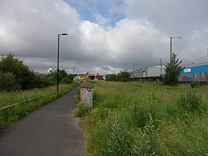
Carville railway station
Former railway station in Tyne and Wear on the Riverside Branch
Distance: Approx. 444 meters
Latitude and longitude: 54.9895,-1.5276
Carville was a railway station on the Riverside Branch, which ran between Byker and Willington Quay. The station served Wallsend in North Tyneside. The station was opened to passengers on 1 August 1891 by the North Eastern Railway.
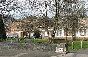
Sir G B Hunter Memorial Hospital
Hospital in England
Distance: Approx. 595 meters
Latitude and longitude: 54.9962,-1.5312
The Sir G B Hunter Memorial Hospital is a health facility at Wallsend Green, Wallsend, Tyne and Wear, England. It is managed by Cumbria, Northumberland, Tyne and Wear NHS Foundation Trust.
Wallsend Town Hall
Municipal building in Wallsend, Tyne and Wear, England
Distance: Approx. 479 meters
Latitude and longitude: 54.9919,-1.5266
Wallsend Town Hall is a municipal building on High Street East in Wallsend, Tyne and Wear, England. The town hall, which was the headquarters of North Tyneside Council from 1974 to 2008, is a Grade II listed building.
Weather in this IP's area
broken clouds
14 Celsius
13 Celsius
13 Celsius
14 Celsius
1005 hPa
77 %
1005 hPa
1001 hPa
10000 meters
4.63 m/s
10.8 m/s
210 degree
75 %
07:41:57
18:00:10