Country:
 Great Britain
Region:
City:
Latitude and Longitude:
Time Zone:
Postal Code:
IP information under different IP Channel
ip-api
Country
Region
City
ASN
Time Zone
ISP
Blacklist
Proxy
Latitude
Longitude
Postal
Route
IPinfo
Country
Region
City
ASN
Time Zone
ISP
Blacklist
Proxy
Latitude
Longitude
Postal
Route
MaxMind
Country
Region
City
ASN
Time Zone
ISP
Blacklist
Proxy
Latitude
Longitude
Postal
Route
Luminati
Country
GBRegion
eng
City
ipswich
ASN
Time Zone
Europe/London
ISP
Infinity Developments Limited
Latitude
Longitude
Postal
db-ip
Country
Region
City
ASN
Time Zone
ISP
Blacklist
Proxy
Latitude
Longitude
Postal
Route
ipdata
Country
Region
City
ASN
Time Zone
ISP
Blacklist
Proxy
Latitude
Longitude
Postal
Route
Popular places and events near this IP address

Baldock
Town in Hertfordshire, England
Distance: Approx. 1057 meters
Latitude and longitude: 51.99,-0.19
Baldock ( BAWL-dək) is a historic market town in the North Hertfordshire district of Hertfordshire, England. The River Ivel rises from springs in the town. It lies 33 miles (53 km) north of London and 14 miles (23 km) north northwest of the county town of Hertford.

North Hertfordshire
UK local government district
Distance: Approx. 1205 meters
Latitude and longitude: 52,-0.2
North Hertfordshire is one of ten local government districts in the county of Hertfordshire, England. Its council is based in Letchworth Garden City and the largest town is Hitchin. The district also includes the towns of Baldock and Royston and numerous villages and surrounding rural areas.

Norton, Hertfordshire
Human settlement in England
Distance: Approx. 662 meters
Latitude and longitude: 51.9936,-0.2127
Norton is a small village and former civil parish in Hertfordshire, England, one of the three original villages which were absorbed into Letchworth Garden City, the other two being Willian and Old Letchworth. The village is known to have existed by 1007, with remains of the medieval settlement visible as earthworks in a field beside the church. However, the history of the village goes back even further than that.
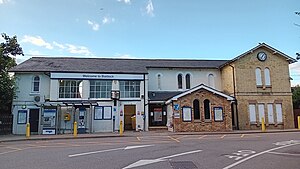
Baldock railway station
Railway station in Hertfordshire, England
Distance: Approx. 1249 meters
Latitude and longitude: 51.993,-0.188
Baldock railway station serves the historic market town of Baldock in Hertfordshire, England. It is on the Cambridge Line, 36 miles 47 chains (58.9 km) north of London King's Cross, and is located on the outskirts of Baldock on Station Road.

Norton School
Comprehensive school in Letchworth, Hertfordshire, England
Distance: Approx. 948 meters
Latitude and longitude: 51.98922,-0.21921
Norton School was a secondary school in Letchworth, Hertfordshire that was founded in 1905 and which closed in 2002 following a period of being in special measures. It has since been partially demolished and redeveloped as a collection of housing and apartments by Miller Homes.

The Knights Templar School
Academy in Baldock, Hertfordshire, England
Distance: Approx. 1029 meters
Latitude and longitude: 51.98766,-0.19077
The Knights Templar School is a co-educational secondary school with academy status located in the market town of Baldock in North Hertfordshire, England. In a February 2006 Ofsted report, the school was described as "outstanding", one of only eight secondary schools in Hertfordshire to be so recognised. It retained its "outstanding" status following a further Ofsted inspection in February 2009.

Church of St Mary the Virgin, Baldock
Church in Hertfordshire, England
Distance: Approx. 1070 meters
Latitude and longitude: 51.9897,-0.1898
The Church of St Mary the Virgin is a parish church of the Church of England in Baldock in Hertfordshire. Dedicated to the Virgin Mary, the original church on the site dated to about 1150 and was built by the Knights Templar before being largely rebuilt in about 1330 by the Knights Hospitaller. It is a Grade I listed building.

Church of St Nicholas, Norton
Church in Hertfordshire, England
Distance: Approx. 591 meters
Latitude and longitude: 51.9948,-0.2078
The Church of St Nicholas in Norton in Hertfordshire was originally the parish church for the village of Norton, which today has become a suburb of Letchworth Garden City. The present building dates from about 1109 to 1119, with additions in the 15th century including the tower. Before the Reformation it was a stopping point on the pilgrim route to the Abbey of St Albans and the shrine there.

Ivel Springs
Distance: Approx. 935 meters
Latitude and longitude: 51.9942,-0.1939
Ivel Springs is a 15.4 hectare Local Nature Reserve in Baldock in Hertfordshire. It is owned and managed by North Hertfordshire District Council, assisted by the Friends of Baldock Green Spaces. The site, which was a rubbish dump until the 1950s, has habitats including woodland, wetland and pasture.

Baldock Cemetery
Cemetery in Hertfordshire, England
Distance: Approx. 642 meters
Latitude and longitude: 51.990101,-0.196069
Baldock Cemetery is the burial ground for the market town of Baldock in North Hertfordshire and the surrounding area. It is maintained by North Hertfordshire District Council. Baldock Cemetery opened in the early twentieth century when the churchyard of the nearby Church of St Mary the Virgin was closed for burials.

Church of St George, Letchworth
Church in Hertfordshire, England
Distance: Approx. 1155 meters
Latitude and longitude: 51.98706,-0.22171
St George's Church is an Anglican church of modern design in the Parish of Norton in Letchworth Garden City in Hertfordshire. Opening in 1964 and arrow-shaped with a 120-foot concrete spire, the congregation are seated in a semi-circle facing the altar.

Baldock Town Hall
Municipal building in Baldock, Hertfordshire, England
Distance: Approx. 1139 meters
Latitude and longitude: 51.9894,-0.1888
Baldock Town Hall is a municipal building in the High Street, Baldock, Hertfordshire, England. The structure, which now operates as an arts and heritage centre, is a locally listed building.
Weather in this IP's area
overcast clouds
13 Celsius
13 Celsius
13 Celsius
14 Celsius
993 hPa
95 %
993 hPa
984 hPa
5450 meters
0.45 m/s
1.34 m/s
134 degree
100 %
07:13:49
18:22:27