Country:
 Great Britain
Region:
City:
Latitude and Longitude:
Time Zone:
Postal Code:
IP information under different IP Channel
ip-api
Country
Region
City
ASN
Time Zone
ISP
Blacklist
Proxy
Latitude
Longitude
Postal
Route
IPinfo
Country
Region
City
ASN
Time Zone
ISP
Blacklist
Proxy
Latitude
Longitude
Postal
Route
MaxMind
Country
Region
City
ASN
Time Zone
ISP
Blacklist
Proxy
Latitude
Longitude
Postal
Route
Luminati
Country
GBASN
Time Zone
Europe/London
ISP
Infinity Developments Limited
Latitude
Longitude
Postal
db-ip
Country
Region
City
ASN
Time Zone
ISP
Blacklist
Proxy
Latitude
Longitude
Postal
Route
ipdata
Country
Region
City
ASN
Time Zone
ISP
Blacklist
Proxy
Latitude
Longitude
Postal
Route
Popular places and events near this IP address
Chesterton, Cambridge
Human settlement in England
Distance: Approx. 928 meters
Latitude and longitude: 52.21850556,0.14144444
Chesterton is a suburb in the northeast corner of Cambridge, in the Cambridge district, in the county of Cambridgeshire, England, 2 miles (3.2 km) north of Cambridge station, on the north bank of the River Cam.

Lady Margaret Boat Club
University rowing club affiliated to St John's College, Cambridge
Distance: Approx. 1249 meters
Latitude and longitude: 52.21347222,0.12611111
The Lady Margaret Boat Club (abbreviated to "LMBC" and known as "Maggie") is the rowing club for members of St John's College, Cambridge, England. The club is named after Lady Margaret Beaufort, founder of the College.

A1309 road
Road in Cambridgeshire, England
Distance: Approx. 524 meters
Latitude and longitude: 52.22387,0.13917
The A1309 is a short road (6.5 miles) which links the two ends of the A10 to north and south of Cambridge city centre in Cambridgeshire, England. It was numbered as part of the A10 prior to the construction of the Cambridge Western Bypass (now M11) and the Northern Bypass (originally A45, now A14). Its northern end is at the Milton Interchange with the A14 and A10.
City Ground (Cambridge)
Football stadium and greyhound racing track in England
Distance: Approx. 1064 meters
Latitude and longitude: 52.21638889,0.1225
The City Ground (also known as Milton Road) was a football stadium and greyhound racing track, in Cambridge, England.
King's Hedges
Human settlement in England
Distance: Approx. 534 meters
Latitude and longitude: 52.22889,0.13312
King's Hedges is an electoral ward in the north of the city of Cambridge, England.
Chesterton Community College
Academy in Cambridge, Cambridgeshire, England
Distance: Approx. 1070 meters
Latitude and longitude: 52.2174,0.12042
Chesterton Community College is a coeducational secondary school with academy status, located in Chesterton, Cambridge, in the county of Cambridgeshire, England. It was established in 1935 as two separate schools for boys and girls, which merged in 1974 to form a mixed comprehensive school and adult centre. Chesterton was granted Community College status in 1983, and became an academy in 2011.

Arbury
Suburb of Cambridge, England
Distance: Approx. 993 meters
Latitude and longitude: 52.2234,0.117
Arbury is a suburb and electoral ward in Cambridge, England. Located in the north of the city, the ward borders the following other wards (from north, proceeding clockwise): Histon, King's Hedges, West Chesterton, and Castle. As of the 2021 United Kingdom census, the ward's population was 9,883 people.
North Cambridge Academy
Secondary school in Cambridge, Cambridgeshire, England
Distance: Approx. 117 meters
Latitude and longitude: 52.2252,0.13098
North Cambridge Academy is a small secondary school with academy status, located in North Cambridge, England. Founded in 1959 the school has also been known as Manor Community College, and The Manor.

Chesterton Hall
Historic house in Cambridge, Cambridgeshire, England, UK
Distance: Approx. 906 meters
Latitude and longitude: 52.2164,0.1353
Chesterton Hall is a house in Chesterton, Cambridge. It lies in the city of Cambridge in the county of Cambridgeshire approximately 50 miles (80 km) north-northeast of London. Most of the grounds have long since been sold off and the house is now located on one of the major roundabouts of the city.

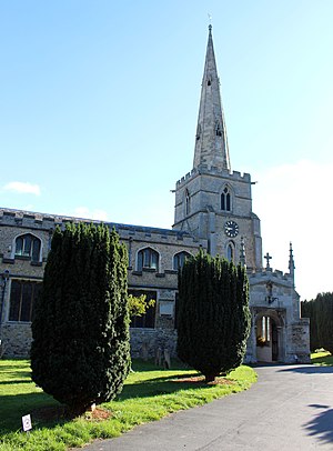
St Laurence's Church, Cambridge
Church in Cambridge, United Kingdom
Distance: Approx. 687 meters
Latitude and longitude: 52.218145,0.129572
The Church of St Laurence is a Roman Catholic church in Cambridge, England. Dedicated to St Laurence of Rome, it is part of the Diocese of East Anglia, within the Province of Westminster. The parish is part of St Andrew's Deanery and is one of three parishes serving the city of Cambridge, the other two being Our Lady and the English Martyrs and St Philip Howard.
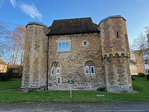
Chesterton Tower
Grade I listed building in Cambridge, United Kingdom
Distance: Approx. 994 meters
Latitude and longitude: 52.21694444,0.14
Chesterton Tower is a Grade I listed medieval tower located in Chapel Street, Chesterton, Cambridge. The two-storey 14th-century tower is the former residence of Italian procurators of the abbot of Vercelli in Italy. It stands in the former vicarage garden of nearby St Andrew's Church, Chesterton.

St Andrew's Church, Chesterton
Church in Cambridge, England
Distance: Approx. 1127 meters
Latitude and longitude: 52.21541667,0.13972222
St Andrew's Church, Chesterton is a Church of England parish church in Chesterton, Cambridge. It is a Grade I listed building. A church was first recorded on this site around 1200.
Weather in this IP's area
light rain
17 Celsius
17 Celsius
16 Celsius
18 Celsius
1004 hPa
88 %
1004 hPa
1002 hPa
10000 meters
6.17 m/s
7.31 m/s
178 degree
3 %
06:23:02
19:31:27