Country:
 Romania
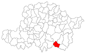
Region:
City:
Latitude and Longitude:
Time Zone:
Postal Code:
IP information under different IP Channel
ip-api
Country
Region
City
ASN
Time Zone
ISP
Blacklist
Proxy
Latitude
Longitude
Postal
Route
IPinfo
Country
Region
City
ASN
Time Zone
ISP
Blacklist
Proxy
Latitude
Longitude
Postal
Route
MaxMind
Country
Region
City
ASN
Time Zone
ISP
Blacklist
Proxy
Latitude
Longitude
Postal
Route
Luminati
Country
RORegion
cj
City
campiaturzii
ASN
Time Zone
Europe/Bucharest
ISP
Orange Romania S.A.
Latitude
Longitude
Postal
db-ip
Country
Region
City
ASN
Time Zone
ISP
Blacklist
Proxy
Latitude
Longitude
Postal
Route
ipdata
Country
Region
City
ASN
Time Zone
ISP
Blacklist
Proxy
Latitude
Longitude
Postal
Route
Popular places and events near this IP address
Bata, Arad
Commune in Arad, Romania
Distance: Approx. 9228 meters
Latitude and longitude: 46.01666667,22.03333333
Bata (Hungarian: Batta) is a commune in Arad County, Romania, in the historical region of Banat. The commune lies in the contact zone of the Lipovei Plateau and the large deep valley of the Mureș River, respectively in the Brănișca-Păuliș Couloir. It is composed of four villages: Bacău de Mijloc (Bakamező), Bata (situated at 67 km from Arad), Bulci (Bulcs) and Țela (Cella).

Bârzava, Arad
Commune in Arad, Romania
Distance: Approx. 8234 meters
Latitude and longitude: 46.11666667,21.98333333
Bârzava (Hungarian: Berzova) is a commune in Arad County, Romania. The commune Bârzava is situated at the foot of Zărand Mountains, at its contact point with Metaliferi Mountains, along the river Bârzava - a right tributary of the Mureș. It is composed of eight villages: Bârzava (situated at 61 km from Arad), Bătuța (Battuca), Căpruța (Kapruca), Dumbrăvița (Alsódombró), Groșii Noi (Garassa), Lalașinț (Lalánc), Monoroștia (Marosmonyoró) and Slatina de Mureș (Marosszlatina).
Stejar (river)
River in Arad County, Romania
Distance: Approx. 9579 meters
Latitude and longitude: 46.012,22.1302
The Stejar (Hungarian: Szarvaság) is a right tributary of the river Mureș in Romania. It discharges into the Mureș in Stejar. Its length is 16 km (9.9 mi) and its basin size is 45 km2 (17 sq mi).

Grosul
River in Arad County, Romania
Distance: Approx. 4869 meters
Latitude and longitude: 46.0878,22.021
The Grosul (Hungarian: Gróssi-patak) is a right tributary of the river Mureș in Romania. It discharges into the Mureș in Căpruța. Its length is 20 km (12 mi) and its basin size is 81 km2 (31 sq mi).
Monoroștia
River in Arad County, Romania
Distance: Approx. 5682 meters
Latitude and longitude: 46.0913,22.0102
The Monoroștia (Hungarian: Monorostyai-patak) is a right tributary of the river Mureș in Romania. It discharges into the Mureș in the village Monoroștia. Its length is 12 km (7.5 mi) and its basin size is 31 km2 (12 sq mi).
Suliniș
River in Arad County, Romania
Distance: Approx. 5707 meters
Latitude and longitude: 46.053,22.0355
The Suliniș (Hungarian: Battai-patak) is a left tributary of the river Mureș in Romania. It discharges into the Mureș in Bata. Its length is 11 km (6.8 mi) and its basin size is 24 km2 (9.3 sq mi).
Bârzava (Mureș)
River in Arad County, Romania
Distance: Approx. 8315 meters
Latitude and longitude: 46.091,21.9761
The Bârzava (Hungarian: Berzova-patak) is a right tributary of the river Mureș in Romania. It discharges into the Mureș in the village Bârzava. Its length is 18 km (11 mi) and its basin size is 44 km2 (17 sq mi).

Julița
River in Arad County, Romania
Distance: Approx. 9239 meters
Latitude and longitude: 46.0146,22.1277
The Julița (Hungarian: Gyulica-patak) is a right tributary of the river Mureș in Romania. It discharges into the Mureș near the village Vărădia de Mureș. Its length is 25 km (16 mi) and its basin size is 78 km2 (30 sq mi).

Vărădia de Mureș
Commune in Arad, Romania
Distance: Approx. 9803 meters
Latitude and longitude: 46.01666667,22.15
Vărădia de Mureș (colloquially Totvărădia, or "Slovak Vărădia"; Hungarian: Tótvárad; German: Waradia, Turkish: Varadiye) is a commune in Arad County, Romania. It stretches over approximately 12600 hectares, situated in the contact zone of Metaliferi Mountains and Zărandului Mountains, respectively partially in the large valley of the Mureș River. It is composed of six villages: Baia (Kisbaja), Julița (Gyulatő), Lupești (Farkasháza), Nicolae Bălcescu (Alsóköves), Stejar (Szarvaság) and Vărădia de Mureș (situated at 81 km from Arad).

Castra of Bulci
Fort in the Roman province of Dacia
Distance: Approx. 9366 meters
Latitude and longitude: 46.011608,22.120492
The castra of Bulci was a fort in the Roman province of Dacia located on the western side of defensive line of forts, limes Daciae. Its ruins are located in Bulci (commune Bata, Romania).
Weather in this IP's area
light rain
9 Celsius
8 Celsius
9 Celsius
9 Celsius
1018 hPa
82 %
1018 hPa
991 hPa
10000 meters
1.92 m/s
2.16 m/s
102 degree
07:39:19
18:58:40