Country:
 USA
USARegion:
City:
Latitude and Longitude:
Time Zone:
Postal Code:
IP information under different IP Channel
ip-api
Country
Region
City
ASN
Time Zone
ISP
Blacklist
Proxy
Latitude
Longitude
Postal
Route
IPinfo
Country
Region
City
ASN
Time Zone
ISP
Blacklist
Proxy
Latitude
Longitude
Postal
Route
MaxMind
Country
Region
City
ASN
Time Zone
ISP
Blacklist
Proxy
Latitude
Longitude
Postal
Route
Luminati
Country
USRegion
md
City
owingsmills
ASN
Time Zone
America/New_York
ISP
CONSTELLATION-ENERGY
Latitude
Longitude
Postal
db-ip
Country
Region
City
ASN
Time Zone
ISP
Blacklist
Proxy
Latitude
Longitude
Postal
Route
ipdata
Country
Region
City
ASN
Time Zone
ISP
Blacklist
Proxy
Latitude
Longitude
Postal
Route
Popular places and events near this IP address

Owings Mills, Maryland
Census-designated place in Maryland, United States
Distance: Approx. 1910 meters
Latitude and longitude: 39.41222222,-76.79305556
Owings Mills is an unincorporated community and census-designated place in Baltimore County, Maryland, United States. It is a suburb of Baltimore. Per the 2020 census, the population was 35,674.
WZBA
Radio station in Maryland, United States
Distance: Approx. 2681 meters
Latitude and longitude: 39.44733333,-76.77969444
WZBA (100.7 FM, "100.7 The Bay") is a commercial FM radio station licensed to serve Westminster, Maryland. The station is owned by Times-Shamrock Communications and broadcasts a classic rock format. Its studios are in Hunt Valley and its broadcast tower is located near Owings Mills at (39°26′49.9″N 76°46′47.2″W).

Owings Mills station
Metro SubwayLink station
Distance: Approx. 1800 meters
Latitude and longitude: 39.4075,-76.78
Owings Mills station is a Metro SubwayLink station in Owings Mills, Maryland. The station is experiencing transit-oriented development from Metro Centre at Owings Mills, bringing many apartments, office space, retail, restaurants, and condominiums to the area adjacent to the station. It has more parking spaces than all other stops along the line.

Rosewood Center
Hospital in Maryland, United States
Distance: Approx. 462 meters
Latitude and longitude: 39.42361111,-76.77083333
The Rosewood Center was an institution for people with developmental disabilities located on Rosewood Lane in Owings Mills, Maryland. It was established in 1888 as the Asylum and Training School for the Feeble-Minded. From 1912 to 1961, it was known as the Rosewood State Training School.
WCAO
Radio station in Baltimore, Maryland
Distance: Approx. 1434 meters
Latitude and longitude: 39.42972222,-76.76166667
WCAO (600 AM "Heaven 600") is a commercial radio station in Baltimore, Maryland. It broadcasts an urban gospel radio format and is owned by iHeartMedia, Inc. It also airs some Christian talk and teaching programs.

Owings Mills High School
Public secondary school in Owings Mills, Maryland, United States
Distance: Approx. 1593 meters
Latitude and longitude: 39.42305556,-76.79472222
Owings Mills High School (OMHS) is a four-year public high school in Owings Mills, Maryland, United States. It is part of the Baltimore County Public Schools consolidated school district.

Owings Mills Mall
Former shopping mall in Owings Mills, Maryland
Distance: Approx. 2118 meters
Latitude and longitude: 39.4075,-76.78972222
Owings Mills Mall was a shopping mall in Owings Mills, Maryland, United States that hosted 155 stores and eateries, in the Baltimore County, Maryland, community of Owings Mills. It was owned and managed by General Growth Properties (now Brookfield Properties). While its main entrance was off Red Run Boulevard between Painters Mill Road and Owings Mills Boulevard, the mall was also accessible from the exit ramps of I-795.
Gwynnbrook Wildlife Management Area
Wildlife Management Area
Distance: Approx. 2563 meters
Latitude and longitude: 39.44638889,-76.77777778
Gwynnbrook Wildlife Management Area is an 88-acre (36 ha) Wildlife Management Area in Owings Mills, Baltimore County, Maryland. The property is a former game farm that was purchased by Maryland in 1919, and is the oldest WMA in the state.

St. Thomas Church (Owings Mills, Maryland)
Historic church in Maryland, United States
Distance: Approx. 1237 meters
Latitude and longitude: 39.42194444,-76.76194444
St. Thomas' Episcopal Church is a parish of the Episcopal Church in Owings Mills, Baltimore County, Maryland, part of the Diocese of Maryland. It is noted for its historic parish church, built in 1743.
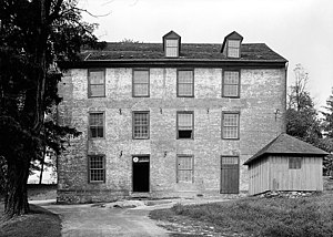
Owings Upper Mill
United States historic place
Distance: Approx. 619 meters
Latitude and longitude: 39.421936,-76.78314
The Owings Upper Mill (also known as A.E. Groff's Flour Mill) is a historic grist mill located at Owings Mills, Baltimore County, Maryland, United States. It is a large 3+1⁄2-story brick structure, 50 by 60 feet (15 by 18 m). The building stands on a low stone foundation, surmounted by a molded brick water table.

Irvine Nature Center
Distance: Approx. 1280 meters
Latitude and longitude: 39.433,-76.768
Irvine Nature Center is a nature center in Owings Mills, Maryland. The center, which is set on 210 acres (0.85 km2) of land in the Caves Valley Historic District, includes a 17,200-square-foot (1,600 m2) green exhibit hall, classrooms, outdoor classroom, a Native American Education site, amphitheater and 8+ miles trails. Irvine is home to the Nature Preschool and Earth Friends Homeschool.
Foundry Row
Shopping mall in Maryland, U.S.
Distance: Approx. 1215 meters
Latitude and longitude: 39.41272,-76.7733
Foundry Row is a lifestyle center/mixed-use development built on the former site of a Solo Cup Company factory in Owings Mills, Maryland, United States. Its anchor stores are Wegmans, Old Navy and Designer Shoe Warehouse. The center is located on the corner of Painters Mill Road and on the 10100 block on Maryland Route 140, providing easy access to the Owings Mills station and its neighboring Metro Centre at Owings Mills.
Weather in this IP's area
clear sky
9 Celsius
8 Celsius
7 Celsius
11 Celsius
1016 hPa
86 %
1016 hPa
996 hPa
10000 meters
2.58 m/s
5.9 m/s
323 degree
07:10:16
18:38:26