216.81.116.38 - IP Lookup: Free IP Address Lookup, Postal Code Lookup, IP Location Lookup, IP ASN, Public IP
Country:
 USA
USARegion:
City:
Location:
Time Zone:
Postal Code:
ISP:
ASN:
language:
User-Agent:
Proxy IP:
Blacklist:
IP information under different IP Channel
ip-api
Country
Region
City
ASN
Time Zone
ISP
Blacklist
Proxy
Latitude
Longitude
Postal
Route
db-ip
Country
Region
City
ASN
Time Zone
ISP
Blacklist
Proxy
Latitude
Longitude
Postal
Route
IPinfo
Country
Region
City
ASN
Time Zone
ISP
Blacklist
Proxy
Latitude
Longitude
Postal
Route
IP2Location
216.81.116.38Country
usRegion
georgia
City
baxley
Time Zone
America/New_York
ISP
Language
User-Agent
Latitude
Longitude
Postal
ipdata
Country
Region
City
ASN
Time Zone
ISP
Blacklist
Proxy
Latitude
Longitude
Postal
Route
Popular places and events near this IP address

Appling County, Georgia
County in Georgia, United States
Distance: Approx. 6365 meters
Latitude and longitude: 31.75,-82.29
Appling County is a county located in the southeastern part of the U.S. state of Georgia. As of the 2020 census, the population was 18,444. The county seat is Baxley.
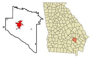
Baxley, Georgia
City in Georgia, United States
Distance: Approx. 339 meters
Latitude and longitude: 31.77527778,-82.3475
Baxley is a city in Appling County, Georgia, United States. As of the 2020 census, the city had a population of 4,942. The city is the county seat of Appling County.

Province of Georgia
British colony in North America (1732–1776)
Distance: Approx. 2077 meters
Latitude and longitude: 31.761,-82.357
The Province of Georgia (also Georgia Colony) was one of the Southern Colonies in colonial-era British America. In 1775 it was the last of the Thirteen Colonies to support the American Revolution. The original land grant of the Province of Georgia included a narrow strip of land that extended west to the Pacific Ocean.

Appling County High School
American public school in Georgia, USA.
Distance: Approx. 1739 meters
Latitude and longitude: 31.76346,-82.3546
Appling County High School (formerly known as Appling County Comprehensive High School) is a high school in Baxley, Appling County, Georgia, United States. It is part of the Appling County School District. It has approximately 1,000 students and 70 teachers in grades 9-12.

Appling County School District
School district in Georgia (U.S. state)
Distance: Approx. 3628 meters
Latitude and longitude: 31.745613,-82.349032
The Appling County School District is a public school district in Appling County, Georgia, United States, based in Baxley. It serves the communities of Baxley, Graham, and Surrency.
Appling County Courthouse
United States historic place
Distance: Approx. 75 meters
Latitude and longitude: 31.77805,-82.34927
The Appling County Courthouse, located in Baxley, Georgia, was built in 1907–1908 at a cost of $50,000. It is in the Neoclassical style and is constructed of limestone and concrete. The interior is a cross pattern with four entrances.

Citizens Banking Company
United States historic place
Distance: Approx. 109 meters
Latitude and longitude: 31.77722222,-82.34861111
The Citizens Banking Company, at 112-116 N. Main St. in Baxley in Appling County, Georgia, was built in 1911. It was listed on the National Register of Historic Places in 1985.

C. W. Deen House
Historic house in Georgia, United States
Distance: Approx. 263 meters
Latitude and longitude: 31.78055556,-82.34833333
The C. W. Deen House, at 413 N. Main St. in Baxley in Appling County, Georgia, was built during 1894–1897. It was listed on the National Register of Historic Places in 1982.

United States Post Office-Baxley, Georgia
United States historic place
Distance: Approx. 143 meters
Latitude and longitude: 31.77805556,-82.35
The United States Post Office-Baxley, Georgia on Tippins Street in Baxley in Appling County, Georgia is a Colonial Revival-style post office built in 1935–1936. It was listed on the National Register of Historic Places in 2000. It is a small one-story post office which is "similar in size, scale, materials, and architectural style to many of the other approximately sixty-five post offices built in Georgia" during the 1930s.

Holmesville, Georgia
Unincorporated community in Georgia, U.S.
Distance: Approx. 8685 meters
Latitude and longitude: 31.70388889,-82.32055556
Holmesville is an unincorporated community in Appling County, in the U.S. state of Georgia.
Weather in this IP's area
clear sky
26 Celsius
26 Celsius
26 Celsius
26 Celsius
1020 hPa
55 %
1020 hPa
1013 hPa
10000 meters
2.74 m/s
3.24 m/s
259 degree