216.7.112.251 - IP Lookup: Free IP Address Lookup, Postal Code Lookup, IP Location Lookup, IP ASN, Public IP
Country:
 USA
USARegion:
City:
Location:
Time Zone:
Postal Code:
ISP:
ASN:
language:
User-Agent:
Proxy IP:
Blacklist:
IP information under different IP Channel
ip-api
Country
Region
City
ASN
Time Zone
ISP
Blacklist
Proxy
Latitude
Longitude
Postal
Route
db-ip
Country
Region
City
ASN
Time Zone
ISP
Blacklist
Proxy
Latitude
Longitude
Postal
Route
IPinfo
Country
Region
City
ASN
Time Zone
ISP
Blacklist
Proxy
Latitude
Longitude
Postal
Route
IP2Location
216.7.112.251Country
usRegion
oregon
City
klamath falls
Time Zone
America/Los_Angeles
ISP
Language
User-Agent
Latitude
Longitude
Postal
ipdata
Country
Region
City
ASN
Time Zone
ISP
Blacklist
Proxy
Latitude
Longitude
Postal
Route
Popular places and events near this IP address

Klamath Falls, Oregon
City in Oregon, United States
Distance: Approx. 45 meters
Latitude and longitude: 42.225,-121.78166667
Klamath Falls ( KLAM-əth) is a city in, and the county seat of, Klamath County, Oregon, United States. The city was originally called Linkville when George Nurse founded the town in 1867. It was named after the Link River, on whose falls the city was sited.
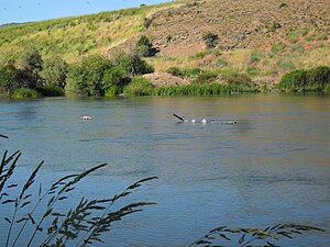
Link River
Short river in southern Oregon, United States
Distance: Approx. 857 meters
Latitude and longitude: 42.21888889,-121.78833333
The Link River is a short river connecting Upper Klamath Lake to Lake Ewauna in the city of Klamath Falls in the U.S. state of Oregon. Draining a basin of 3,810 square miles (9,900 km2), the river begins at the southern end of Klamath Lake and flows a short distance to the Link River Dam and continues 1.5 miles (2.4 km) to the head of Lake Ewauna. The "falls" from which Klamath Falls derives its name, and which in reality are best described as rapids rather than falls, are visible a short distance below the dam, though the water flow is generally insufficient to provide water flow over the rocks.

Judge Henry L. Benson House
United States historic place
Distance: Approx. 505 meters
Latitude and longitude: 42.22303889,-121.78765472
The Judge Henry L. Benson House, built in 1892, is an historic octagon house located at 137 High Street in Klamath Falls, Oregon. In 1981 it was added to the National Register of Historic Places. It is a two-story frame house, built to a T-shaped plan with two symmetrical octagonal towers.

Klamath Union High School
Public school in Klamath Falls, Oregon, United States
Distance: Approx. 663 meters
Latitude and longitude: 42.2305,-121.7788
Klamath Union High School is a public high school located in Klamath Falls, Oregon, United States.
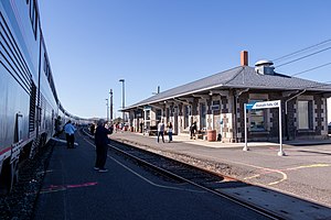
Klamath Falls station
Train station in Klamath Falls, Oregon, U.S.
Distance: Approx. 858 meters
Latitude and longitude: 42.2255,-121.7718
Klamath Falls station is a train station in Klamath Falls, Oregon, served by Amtrak's Coast Starlight. Located at 1600 Oak Avenue, the station building has a waiting room with a ticket agent. Klamath Falls is the southernmost station in Oregon.

Winthrow-Melhase Block
United States historic place
Distance: Approx. 152 meters
Latitude and longitude: 42.22388889,-121.78305556
Winthrow-Melhase Block, also known as Stevens Hotel, was built in 1906 in Klamath Falls, Oregon. It was listed on the National Register of Historic Places in 1982. The building was severely damaged by the 1993 Klamath Falls earthquakes, and was subsequently demolished.

Richardson–Ulrich House
Historic house in Oregon, United States
Distance: Approx. 1034 meters
Latitude and longitude: 42.223381,-121.794528
The Richardson–Ulrich House is a historic residence in Klamath Falls, Oregon, United States. The house was listed on the National Register of Historic Places in 1988.
Klamath Falls Veterans Memorial Park
City park in Oregon
Distance: Approx. 663 meters
Latitude and longitude: 42.2201448,-121.7866704
The Klamath Falls Veterans Memorial Park is a recreational park located on Lake Ewauna in downtown Klamath Falls, Oregon, US. It was established in 2007 as a memorial honoring those who have served and/or are serving in the U.S. Armed Forces, Coast Guard and Wartime Merchant Marine. Construction of the 3.30-acre (0 km2) park was overseen by the 173d Fighter wing, Oregon Air National Guard located at Kingsley Field. The City of Klamath Falls oversees the maintenance of the Memorial.
Eagle Ridge High School
School in Klamath Falls, Oregon
Distance: Approx. 457 meters
Latitude and longitude: 42.22333,-121.7772
Eagle Ridge High School is a charter school in Klamath Falls, Oregon

Baldwin Hotel
United States historic place
Distance: Approx. 626 meters
Latitude and longitude: 42.22055556,-121.78666667
The Baldwin Hotel is a historic hotel building in Klamath Falls, Oregon, in the United States. It was built in 1905 and added to the National Register of Historic Places on October 2, 1973. Originally built to be a hardware store by George Baldwin, the building was converted into a hotel in 1911 as George saw the potential profit from the railroad coming to town.

Bisbee Hotel
United States historic place
Distance: Approx. 229 meters
Latitude and longitude: 42.22416667,-121.77972222
The Bisbee Hotel is a hotel building in Klamath Falls, Oregon, in the United States. It was built in 1926 and added to the National Register of Historic Places on October 12, 2006.

Klamath Falls City Hall
United States historic place
Distance: Approx. 227 meters
Latitude and longitude: 42.22333333,-121.78083333
Klamath Falls City Hall is a city hall building in Klamath Falls, Oregon, in the United States. It was built in 1914 and added to the National Register of Historic Places on October 30, 1989. It is a two-and-a-half-story Beaux Arts-style building designed by Earl Veghte, a young architect.
Weather in this IP's area
overcast clouds
-17 Celsius
-21 Celsius
-17 Celsius
-17 Celsius
1031 hPa
88 %
1031 hPa
862 hPa
4828 meters
1.54 m/s
60 degree
100 %