Country:
 USA
USARegion:
City:
Latitude and Longitude:
Time Zone:
Postal Code:
IP information under different IP Channel
ip-api
Country
Region
City
ASN
Time Zone
ISP
Blacklist
Proxy
Latitude
Longitude
Postal
Route
IPinfo
Country
Region
City
ASN
Time Zone
ISP
Blacklist
Proxy
Latitude
Longitude
Postal
Route
MaxMind
Country
Region
City
ASN
Time Zone
ISP
Blacklist
Proxy
Latitude
Longitude
Postal
Route
Luminati
Country
USASN
Time Zone
America/Chicago
ISP
INTERNAP-2BLK
Latitude
Longitude
Postal
db-ip
Country
Region
City
ASN
Time Zone
ISP
Blacklist
Proxy
Latitude
Longitude
Postal
Route
ipdata
Country
Region
City
ASN
Time Zone
ISP
Blacklist
Proxy
Latitude
Longitude
Postal
Route
Popular places and events near this IP address

KSJS
Radio station at San Jose State University
Distance: Approx. 3671 meters
Latitude and longitude: 37.209,-121.776
KSJS (90.5 MHz) is a college radio station that broadcasts 24 hours a day from the campus of San Jose State University in San Jose, California, United States. The brainchild of Professor Clarence Flick, it went on the air on February 11, 1963, with only 85 watts of power. The studio is located in Hugh Gillis Hall, easily accessible to RTVF majors.

Oak Grove High School (San Jose, California)
School in San Jose, California, United States
Distance: Approx. 3503 meters
Latitude and longitude: 37.2528,-121.8199
Oak Grove High School is a comprehensive public secondary school located in the Edenvale neighborhood of San Jose, California, United States, which serves students in grades 9–12. Average enrollment is 1450 students, compared to the state average of 1413. The school is part of the East Side Union High School District and its mascot is the eagle.

Cottle station
VTA light rail station in San Jose, California
Distance: Approx. 1767 meters
Latitude and longitude: 37.242688,-121.802888
Cottle station is a light rail station operated by Santa Clara Valley Transportation Authority (VTA). The station is served by the Blue Line of the VTA light rail system. It was part of the original Guadalupe Line, the first segment of light rail from Santa Teresa to Tasman.

Santa Teresa station
VTA light rail station in San Jose, California
Distance: Approx. 808 meters
Latitude and longitude: 37.236265,-121.789316
Santa Teresa station is a light rail station operated by Santa Clara Valley Transportation Authority (VTA). This station is the southern terminus of the Blue Line of the VTA light rail system. It was built in the late 1980s as part of the original Guadalupe Line, the first segment of light rail that stretched to Tasman in northern San Jose.
Saint Julie Billiart Parish
Church in California, USA
Distance: Approx. 2382 meters
Latitude and longitude: 37.226807,-121.802538
Saint Julie Billiart Parish is a Roman Catholic parish of the Diocese of San Jose in California, located in the Santa Teresa neighborhood of San Jose, California. The parish is named for Saint Julie Billiart, the foundress of the Sisters of Notre Dame de Namur.
KBAY
Country radio station in Gilroy, California
Distance: Approx. 3714 meters
Latitude and longitude: 37.20888889,-121.77416667
KBAY (94.5 FM, "Bay Country 94.5") is a commercial radio station licensed to Gilroy, California, serving San Jose and the San Francisco Bay Area, and broadcasting a country music radio format. KBAY is owned by Alpha Media, along with sister station 106.5 KEZR. The radio studios and offices are located off U.S. Route 101 and Hellyer Ave in South San Jose. KBAY has an effective radiated power (ERP) of 44,000 watts.

Santa Teresa County Park
County park in Santa Clara County
Distance: Approx. 3171 meters
Latitude and longitude: 37.2132,-121.7871
Santa Teresa County Park is an 1,673-acre (6.77 km2) park in the Santa Teresa neighborhood of San Jose, California, located within the Santa Teresa Hills
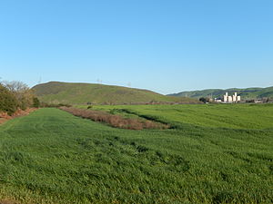
Santa Teresa Hills
Distance: Approx. 3411 meters
Latitude and longitude: 37.21633333,-121.80495139
The Santa Teresa Hills are a range of mountains in Santa Clara County, California, located primarily in the city of San Jose. They separate the San Jose neighborhoods of Almaden Valley to the west and Santa Teresa to the east.
Rancho Santa Teresa
Distance: Approx. 2573 meters
Latitude and longitude: 37.25,-121.81
Rancho Santa Teresa was a 9,647-acre (39.04 km2) Mexican land grant in present-day Santa Clara County, California given in 1834 by Governor José Figueroa to José Joaquín Bernal. The grant extended west from Coyote Creek to the Santa Teresa Hills, and included present-day Santa Teresa.
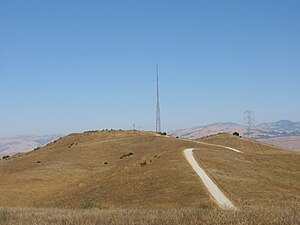
Tulare Hill
Hill in Santa Clara County, California, US
Distance: Approx. 3371 meters
Latitude and longitude: 37.2210554,-121.7549494
Tulare Hill is a prominent hill in the Santa Teresa Hills of western Santa Clara County, California. It lies along the southernmost edge of San Jose, California, adjacent to the Metcalf Energy Center. The hill and surrounding 330 acres (130 ha) of serpentine grasslands are home to the endangered Bay checkerspot butterfly and Dudleya setchellii wildflower.

Fisher Creek
River in California, United States
Distance: Approx. 3675 meters
Latitude and longitude: 37.22444444,-121.7475
Fisher Creek is a 13.8 miles (22.2 km) stream that flows northwesterly through the Coyote Valley in southern Santa Clara County, California, United States. It is a tributary to the largest freshwater wetland in Santa Clara County, Laguna Seca, a seasonal lake important to groundwater recharge. From Laguna Seca, Fisher Creek was connected to Coyote Creek by an artificial channel.

Kaiser San Jose Medical Center
Hospital in California, United States
Distance: Approx. 1594 meters
Latitude and longitude: 37.239392,-121.800795
Kaiser San Jose Medical Center, also known as Kaiser Santa Teresa, is a Kaiser Permanente hospital in San Jose, California, located in the Santa Teresa district of South San Jose. Kaiser San Jose has been ranked within the top 50 best hospitals in the United States by Healthgrades in 2019, 2020, and 2021.
Weather in this IP's area
clear sky
16 Celsius
16 Celsius
13 Celsius
18 Celsius
1011 hPa
81 %
1011 hPa
1004 hPa
10000 meters
06:44:05
19:25:28