Country:
Region:
City:
Latitude and Longitude:
Time Zone:
Postal Code:
IP information under different IP Channel
ip-api
Country
Region
City
ASN
Time Zone
ISP
Blacklist
Proxy
Latitude
Longitude
Postal
Route
Luminati
Country
ASN
Time Zone
America/Chicago
ISP
INTERNAP-2BLK
Latitude
Longitude
Postal
IPinfo
Country
Region
City
ASN
Time Zone
ISP
Blacklist
Proxy
Latitude
Longitude
Postal
Route
db-ip
Country
Region
City
ASN
Time Zone
ISP
Blacklist
Proxy
Latitude
Longitude
Postal
Route
ipdata
Country
Region
City
ASN
Time Zone
ISP
Blacklist
Proxy
Latitude
Longitude
Postal
Route
Popular places and events near this IP address

La Porte, Texas
City in Texas, United States
Distance: Approx. 2077 meters
Latitude and longitude: 29.66472222,-95.04083333
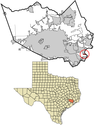
La Porte ( lə PORT) is a city in Harris County, Texas, United States, within the Bay Area of the Houston–Sugar Land–Baytown metropolitan area. As of the 2020 census, the city population was 35,124. La Porte is the fourth-largest incorporated city in Harris County.

Morgan's Point, Texas
City in Texas, United States
Distance: Approx. 2262 meters
Latitude and longitude: 29.67638889,-94.99944444
Morgan's Point is located 30 miles southeast of Houston in southeastern Harris County, Texas, United States, located on the shores of Galveston Bay at the inlet to the Houston Ship Channel, near La Porte and Baytown. As of the 2020 census, it has 273 residents, and is located within the La Porte Independent School District. Morgan's Point National Historic District includes the "Carriage House" otherwise known as City Hall, and the Governor Ross S. Sterling mansion, directly across the street; as well as several other notable properties.

Shoreacres, Texas
City in Texas, United States
Distance: Approx. 5163 meters
Latitude and longitude: 29.61944444,-95.01777778
Shoreacres is a city located in Harris County in the U.S. state of Texas alongside State Highway 146. Established with a mayor-alderman form of city government, it was incorporated in 1949. The population was 1,566 at the 2020 census.

Houston Ship Channel
Canal in Texas
Distance: Approx. 4935 meters
Latitude and longitude: 29.70833333,-95.005
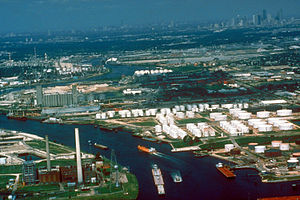
The Houston Ship Channel, in Houston, Texas, is part of the Port of Houston, one of the busiest seaports in the world. The channel is the conduit for ocean-going vessels between Houston-area terminals and the Gulf of Mexico, and it serves an increasing volume of inland barge traffic.

Fred Hartman Bridge
Bridge in Texas and north of La Porte, Texas
Distance: Approx. 4198 meters
Latitude and longitude: 29.70347,-95.01742
The Fred Hartman Bridge is a cable-stayed bridge in the U.S. state of Texas spanning the Houston Ship Channel. The bridge carries 2.6 miles (4.2 km) of State Highway 146 (SH 146), between the cities of Baytown and La Porte (east of Houston). The bridge is also expected to carry State Highway 99 (SH 99) (Grand Parkway) when it is completed around Houston.
Lomax, La Porte, Texas
Neighborhood of La Porte in Harris, Texas, United States
Distance: Approx. 4776 meters
Latitude and longitude: 29.68,-95.066
Lomax is a neighborhood of La Porte, a city in Harris County, Texas, United States. Lomax once was a separate community. The community was named after R.A. Lomax, a native of Illinois who went to the area in 1885 and donated land for a school.
La Porte High School (Texas)
Public secondary school in La Porte, Texas, United States
Distance: Approx. 1448 meters
Latitude and longitude: 29.65361111,-95.01416667
La Porte High School is a High school based in La Porte, Texas, United States. It is part of the La Porte Independent School District. The school serves the cities of La Porte, Morgan's Point, and Shoreacres, as well as a small portion of Pasadena and of Deer Park.
La Porte Municipal Airport (Texas)
Airport
Distance: Approx. 4346 meters
Latitude and longitude: 29.66916667,-95.06416667
La Porte Municipal Airport (FAA LID: T41) is a city-owned public-use airport located three miles (5 km) northwest of the central business district of La Porte, a city in Harris County, Texas, United States.
Baytown Tunnel
Demolished tunnel under the Houston Ship Channel in Texas, US
Distance: Approx. 4432 meters
Latitude and longitude: 29.70555556,-95.01694444
The Baytown Tunnel or Baytown – La Porte Tunnel was a two-lane underwater motor-vehicle tunnel connecting Baytown and La Porte, two suburbs of Houston, Texas. Completed in 1953, it traveled northeast-southwest underneath the Houston Ship Channel and had a length of 4,110 feet (1,250 m). It was closed to vehicular traffic in 1995 with the opening of the Fred Hartman Bridge, and subsequently demolished beginning in 1997 in order for the U.S. Army Corps of Engineers to deepen the channel in 1998.

Barbours Cut Terminal
Port in United States
Distance: Approx. 2717 meters
Latitude and longitude: 29.68194444,-94.99833333
The Barbours Cut Container Terminal, or simply the Barbours Cut Terminal, is a major deep water port in the Greater Houston area in the U.S. state of Texas. It is part of one of the world's busiest ports by cargo tonnage.

Houston Yacht Club
Distance: Approx. 5632 meters
Latitude and longitude: 29.6178,-95.001
The Houston Yacht Club is the oldest yacht club in Texas. In LaPorte, near Houston, it is a member of the Gulf Yachting Association.

NET Power Demonstration Facility
Distance: Approx. 3913 meters
Latitude and longitude: 29.6476,-95.054
The NET Power Test Facility, located in La Porte, Tx, is an oxy-combustion, zero-emissions 50 MWth natural gas power plant owned and operated by NET Power. NET Power is owned by Constellation Energy Corporation, Occidental Petroleum Corporation (Oxy) Low Carbon Ventures, Baker Hughes Company and 8 Rivers Capital, the company holding the patents for the technology. The plant is a first of its kind Allam-Fetvedt Cycle which achieved first-fire in May of 2018.
Weather in this IP's area
light rain
24 Celsius
25 Celsius
23 Celsius
24 Celsius
1011 hPa
91 %
1011 hPa
1010 hPa
10000 meters
4.12 m/s
120 degree
100 %
06:46:49
17:23:48