Country:
 USA
USARegion:
City:
Latitude and Longitude:
Time Zone:
Postal Code:
IP information under different IP Channel
ip-api
Country
Region
City
ASN
Time Zone
ISP
Blacklist
Proxy
Latitude
Longitude
Postal
Route
IPinfo
Country
Region
City
ASN
Time Zone
ISP
Blacklist
Proxy
Latitude
Longitude
Postal
Route
MaxMind
Country
Region
City
ASN
Time Zone
ISP
Blacklist
Proxy
Latitude
Longitude
Postal
Route
Luminati
Country
USASN
Time Zone
America/Chicago
ISP
GREENCLOUD
Latitude
Longitude
Postal
db-ip
Country
Region
City
ASN
Time Zone
ISP
Blacklist
Proxy
Latitude
Longitude
Postal
Route
ipdata
Country
Region
City
ASN
Time Zone
ISP
Blacklist
Proxy
Latitude
Longitude
Postal
Route
Popular places and events near this IP address
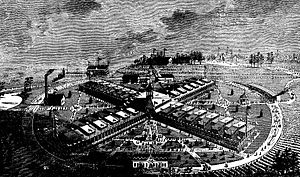
International Cotton Exposition
Exposition held in Atlanta, Georgia, USA it 1881
Distance: Approx. 891 meters
Latitude and longitude: 33.784457,-84.41574
International Cotton Exposition (I.C.E.) was a world's fair held in Atlanta, Georgia, from October 4 to December 31 of 1881. The location was along the Western & Atlantic Railroad tracks near the present-day King Plow Arts Center development in the West Midtown area. It planned to show the progress made since the city's destruction during the Battle of Atlanta and new developments in cotton production.
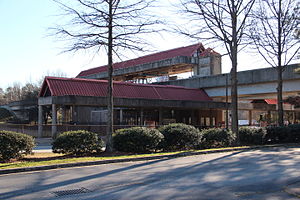
Bankhead station
MARTA rail station
Distance: Approx. 979 meters
Latitude and longitude: 33.77189,-84.42884
Bankhead is a train station in Atlanta, Georgia, the western terminus of the Green Line in the Metropolitan Atlanta Rapid Transit Authority (MARTA) rail system. Bankhead station is located in the Grove Park Neighborhood due to a recent neighborhood expansion. This station primarily serves the neighborhoods of Grove Park, Bankhead, West Lake, Howell Station, and other Westside residents.

Maddox Park
Distance: Approx. 935 meters
Latitude and longitude: 33.771,-84.427
Maddox Park is a 51.5-acre (208,000 m2) community park located in the west side of Atlanta (in the Bankhead neighborhood), across Donald Lee Hollowell Parkway from Bankhead MARTA station. It is approximately 1.5 miles (2.4 km) west of Georgia Tech. The park has an existing rail line running through it, which is part of the proposed route of the Belt Line.
Knight Park–Howell Station
United States historic place
Distance: Approx. 820 meters
Latitude and longitude: 33.785,-84.41972222
Knight Park–Howell Station, also known as Howell Station Historic District, is a National historic district and neighborhood in, Atlanta, Georgia. Almost all buildings in the area were destroyed in the American Civil War, in Sherman's March to the Sea, and all of the buildings in the district were built after 1864. The neighborhood was listed on the National Register of Historic Places in 1997.
Howell Interlocking Historic District
Historic district in Georgia, United States
Distance: Approx. 902 meters
Latitude and longitude: 33.784547,-84.415694
Howell Interlocking Historic District is the area in West Midtown, Atlanta where four railroad lines converge. It is adjacent to the Marietta Street Artery neighborhood, an area rich in industrial history, as an original industrial district built along Atlanta's first railway line (1837).

Goat Farm Arts Center
United States historic place
Distance: Approx. 1043 meters
Latitude and longitude: 33.786228,-84.416226
The Goat Farm Arts Center is a visual and performing arts center located in West Midtown, Atlanta, Georgia. The center is housed in a 19th-century complex of industrial buildings and contains the studio space of over 300 artists. Goat Farm hosts music concerts, traditional and experimental theatrical performances, film screenings, contemporary dance performances, art exhibitions, artist residency programs, and professional ballet and contemporary dance classes.
Howard School (Atlanta)
School in Atlanta, Georgia, United States
Distance: Approx. 1115 meters
Latitude and longitude: 33.787131,-84.416833
The Howard School (THS) is located in Atlanta, Georgia, United States. It was founded by Marian Howard in 1950 to give students alternative approaches to learning. Students with language-based learning disabilities and learning differences from grades K-12 may attend the school.

Ashby Street Car Barn
United States historic place
Distance: Approx. 562 meters
Latitude and longitude: 33.7815,-84.4169
Ashby Street Car Barn, locally known as the Ashby Street Trolley Barn, is a historic interurban carhouse in Atlanta, Georgia. It was constructed by the Atlanta Northern Railway Company in 1927, replacing a previous structure built in 1904. The carhouse was the major maintenance facility for the Atlanta/Marietta interurban, which ran until January 31, 1947.

Midtown West (commercial development)
Distance: Approx. 907 meters
Latitude and longitude: 33.779733,-84.411405
Midtown West is a 12-acre commercial development in West Midtown, Atlanta. It consists of historic warehouse space renovated for use as restaurants, other hospitality and offices. It includes the Brickworks building at the intersection of Howell Mill Rd.
Lindsay Street Park
Distance: Approx. 1032 meters
Latitude and longitude: 33.76944444,-84.41583333
Lindsay Street Park is a public park in the English Avenue neighborhood of Atlanta, Georgia.
Fulton County Jail
Prison in Atlanta, Georgia, United States
Distance: Approx. 284 meters
Latitude and longitude: 33.77888889,-84.42361111
The Fulton County Jail, also referred to as Rice Street, is a prison in Atlanta, Georgia. It was built to hold up to 1,125 prisoners in 1989 but now occasionally tops 3,000.
Hayakawa (restaurant)
Restaurant in Atlanta, Georgia, U.S.
Distance: Approx. 1100 meters
Latitude and longitude: 33.78347222,-84.41125
Hayakawa (formerly Sushi Hayakawa) is a restaurant in Atlanta, Georgia. The restaurant serves Japanese cuisine and received a Michelin star in 2023.
Weather in this IP's area
clear sky
26 Celsius
26 Celsius
24 Celsius
27 Celsius
1010 hPa
49 %
1010 hPa
978 hPa
10000 meters
4.63 m/s
330 degree
07:36:39
19:13:47