Country:
 USA
USARegion:
City:
Latitude and Longitude:
Time Zone:
Postal Code:
IP information under different IP Channel
ip-api
Country
Region
City
ASN
Time Zone
ISP
Blacklist
Proxy
Latitude
Longitude
Postal
Route
IPinfo
Country
Region
City
ASN
Time Zone
ISP
Blacklist
Proxy
Latitude
Longitude
Postal
Route
MaxMind
Country
Region
City
ASN
Time Zone
ISP
Blacklist
Proxy
Latitude
Longitude
Postal
Route
Luminati
Country
USRegion
tx
City
dallas
ASN
Time Zone
America/Chicago
ISP
HBK-ROSEWOOD
Latitude
Longitude
Postal
db-ip
Country
Region
City
ASN
Time Zone
ISP
Blacklist
Proxy
Latitude
Longitude
Postal
Route
ipdata
Country
Region
City
ASN
Time Zone
ISP
Blacklist
Proxy
Latitude
Longitude
Postal
Route
Popular places and events near this IP address

Highland Park, Texas
Town in Texas, United States
Distance: Approx. 1222 meters
Latitude and longitude: 32.83027778,-96.80111111
Highland Park is a town in central Dallas County, Texas, United States. The population was estimated to be 8,719 in 2022, dropping from the previously recorded 8,864 in 2020. It is located between the Dallas North Tollway and U.S. Route 75 (North Central Expressway), 4 miles (6 km) north of downtown Dallas.
Southern Methodist University
Private university in Dallas, Texas, US
Distance: Approx. 1439 meters
Latitude and longitude: 32.83855,-96.78294
Southern Methodist University (SMU) is a private research university in University Park, Texas, with a satellite campus in Taos County, New Mexico. SMU was founded on April 17, 1911, by the Methodist Episcopal Church, South—now part of the United Methodist Church—in partnership with Dallas civic leaders. However, it is nonsectarian in its teaching and enrolls students of all religious affiliations.

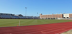
Gerald J. Ford Stadium
American football stadium on the Southern Methodist University campus near Dallas, TX, US
Distance: Approx. 1205 meters
Latitude and longitude: 32.83664444,-96.78399444
Gerald J. Ford Stadium is a stadium in Dallas, Texas. The stadium is owned by Southern Methodist University (SMU) and is used primarily for games played by the SMU Mustangs football team.

Vickery Place, Dallas
Distance: Approx. 1248 meters
Latitude and longitude: 32.82076,-96.777415
Vickery Place is a historic neighborhood in East Dallas, Texas, bounded on the north by Goodwin Avenue, on the west by North Central Expressway (US 75) and Henderson, on the south by Belmont, and on the east by Greenville Avenue. Although Vickery Place is considered by some to be part of the M Streets area, it is strictly speaking not as it is south of the Greenland Hills subdivision. Vickery Place has seen much improvement and property value growth over the past several years due to its close proximity to Downtown Dallas (2–3 miles from Downtown) and Uptown, and its location bordering the vibrant Lower Greenville Avenue and Knox-Henderson entertainment and shopping districts.
Ownby Stadium
Distance: Approx. 1557 meters
Latitude and longitude: 32.83944444,-96.78222222
Ownby Stadium was a stadium in the University Park suburb of Dallas, Texas. It was the home of the Southern Methodist University Mustang football team. In late 1998, the stadium was demolished to build Gerald J. Ford Stadium at the site.
Perkins School of Theology
University in Texas USA founded 1911
Distance: Approx. 1450 meters
Latitude and longitude: 32.839394,-96.785867
Perkins School of Theology is one of Southern Methodist University's three original schools and is located in Dallas, Texas. The theology school was renamed in 1945 to honor benefactors Joe J. and Lois Craddock Perkins of Wichita Falls, Texas. Degree programs include the Master of Divinity (M.Div.), Master of Sacred Music, Master of Theological Studies (MTS), Master of Arts in Ministry, Master of Theology (Th.M.), Doctor of Ministry (D.Min.), and Doctor of Pastoral Music as well as the Ph.D., in cooperation with The Graduate Program in Religious Studies at SMU’s Dedman College of Humanities and Sciences.
Washburne Soccer and Track Stadium
Soccer & track stadium of Southern Methodist University
Distance: Approx. 1583 meters
Latitude and longitude: 32.839733,-96.782317
The Washburne Soccer and Track Stadium (formerly Westcott Field) is a soccer-specific stadium on the campus of Southern Methodist University in University Park, Texas (an enclave of Dallas). It has a capacity of 2,577, and is home to the SMU Mustangs men's and women's soccer teams. The stadium also has a running track for track and field and other athletics competitions.
KAMM (AM)
Radio station in University Park, Texas
Distance: Approx. 1565 meters
Latitude and longitude: 32.836885,-96.777401
KAMM (1540 kHz) is a commercial AM radio station licensed to University Park, Texas, serving the Dallas-Fort Worth Metroplex. It is owned by Richard Witkovski, through licensee North Texas Radio Group, L.P., and is operating at the reduced power of 100 watts under special temporary authority BSTA20230405AAC under authority of the Federal Communications Commission.
Dallas Country Club
Distance: Approx. 1463 meters
Latitude and longitude: 32.835,-96.80083333
Dallas Country Club is a country club located in the town of Highland Park in Dallas County, Texas. Located on the northern end of Exall Lake across from Highland Park Village, its borders are Preston Road on the west, Beverly Drive on the south, Golf Drive on the east, and McFarlin Boulevard on the north.
Armstrong Field
Baseball park in Dallas, Texas, US
Distance: Approx. 1583 meters
Latitude and longitude: 32.839733,-96.782317
Armstrong Field was a baseball park located in Dallas, Texas, on the campus of Southern Methodist University located where Westcott Field now stands. It first hosted SMU football from 1915 through 1925 (Ownby Stadium opened in 1926). It was the home of the SMU baseball team (1919–1980) for many years though at least the final four seasons were played off campus.
Knox–Henderson station
Proposed subway station in Dallas, Texas
Distance: Approx. 738 meters
Latitude and longitude: 32.820303,-96.786322
Knox–Henderson station is a proposed DART light rail station that would serve the Knox-Henderson and Vickery Place neighborhoods of Dallas, Texas. The station would be located in an underground tunnel at the intersection of North Central Expressway (US 75) and Knox Street, and it would serve the Red Line, Orange Line, and Blue Line. During construction of the North Central Expressway subway in the 1990s, the area that would contain the Knox-Henderson station platforms was excavated.

Highland Park United Methodist Church
Church in Texas , USA
Distance: Approx. 1219 meters
Latitude and longitude: 32.837328,-96.78619
Highland Park United Methodist Church is a United Methodist church in Dallas, Texas.
Weather in this IP's area
few clouds
33 Celsius
35 Celsius
32 Celsius
35 Celsius
1010 hPa
45 %
1010 hPa
992 hPa
10000 meters
3.09 m/s
110 degree
20 %
07:11:50
19:32:00