216.49.252.213 - IP Lookup: Free IP Address Lookup, Postal Code Lookup, IP Location Lookup, IP ASN, Public IP
Country:
 USA
USARegion:
City:
Location:
Time Zone:
Postal Code:
ISP:
ASN:
language:
User-Agent:
Proxy IP:
Blacklist:
IP information under different IP Channel
ip-api
Country
Region
City
ASN
Time Zone
ISP
Blacklist
Proxy
Latitude
Longitude
Postal
Route
db-ip
Country
Region
City
ASN
Time Zone
ISP
Blacklist
Proxy
Latitude
Longitude
Postal
Route
IPinfo
Country
Region
City
ASN
Time Zone
ISP
Blacklist
Proxy
Latitude
Longitude
Postal
Route
IP2Location
216.49.252.213Country
usRegion
kansas
City
pittsburg
Time Zone
America/Chicago
ISP
Language
User-Agent
Latitude
Longitude
Postal
ipdata
Country
Region
City
ASN
Time Zone
ISP
Blacklist
Proxy
Latitude
Longitude
Postal
Route
Popular places and events near this IP address

Pittsburg, Kansas
City in Crawford County, Kansas
Distance: Approx. 590 meters
Latitude and longitude: 37.41083333,-94.69833333
Pittsburg is a city in Crawford County, Kansas, United States, located in southeast Kansas near the Missouri state border. It is the most populous city in Crawford County and southeast Kansas. As of the 2020 census, the population of the city was 20,646.

Pittsburg State University
Public university in Pittsburg, Kansas, U.S.
Distance: Approx. 2194 meters
Latitude and longitude: 37.3913,-94.7024
Pittsburg State University (Pitt State or PSU) is a public university in Pittsburg, Kansas, United States. It enrolls approximately 7,400 students (6,000 undergraduates and 1,400 graduate students) and is a member of the Kansas Board of Regents.

John Lance Arena
Pittsburg State Basketball Arena
Distance: Approx. 2346 meters
Latitude and longitude: 37.39166667,-94.69416667
John Lance Arena is a 3,500 seat multi-purpose arena in Pittsburg, Kansas. It was built in 1971 and saw its first game played on December 4, 1971. It is the home of the Pittsburg State University Gorillas basketball teams.
KSEK (AM)
Radio station in Pittsburg, Kansas
Distance: Approx. 2912 meters
Latitude and longitude: 37.39555556,-94.67833333
KSEK (1340 kHz, "Thunder 107.9") is an AM radio station licensed to Pittsburg, Kansas.

St. Mary's-Colgan High School
Parochial school in Pittsburg, Kansas, United States
Distance: Approx. 592 meters
Latitude and longitude: 37.41583333,-94.7025
St. Mary's Colgan High School is a parochial, Roman Catholic high school in Pittsburg, Kansas in the Roman Catholic Diocese of Wichita. It is under the direction of Our Lady of Lourdes Catholic Parish.

Pittsburg High School (Kansas)
High school in Pittsburg, Kansas, United States
Distance: Approx. 2882 meters
Latitude and longitude: 37.40928,-94.672469
Pittsburg High School is a fully accredited public high school located in Pittsburg, Kansas, United States, serving students in grades 9-12. The school is part of Pittsburg USD 250 public school district, is one of the schools in Pittsburg and is the largest high school in southeast Kansas. The school colors are purple and white and the school mascot is the Dragon.
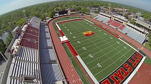
Carnie Smith Stadium
Football stadium in Pittsburg, Kansas, US
Distance: Approx. 2240 meters
Latitude and longitude: 37.39124,-94.699601
Carnie Smith Stadium (formerly Brandenburg Stadium) is the football stadium for Pittsburg State University in Pittsburg, Kansas.

Baker Township, Crawford County, Kansas
Township in Kansas, United States
Distance: Approx. 2743 meters
Latitude and longitude: 37.40666667,-94.67444444
Baker Township is a township in Crawford County, Kansas, United States. As of the 2010 census, its population was 3,408.

Pittsburg Public Library
United States historic place
Distance: Approx. 198 meters
Latitude and longitude: 37.41111111,-94.70722222
The Pittsburg Public Library is a public library in Pittsburg, Kansas, United States. A part of the Southeast Kansas Library System, it circulates a collection of over 70,000 items. Its Prairie Style building was built in 1910 through a donation from Andrew Carnegie.
Ascension Via Christi Hospital in Pittsburg
Hospital in Kansas, United States
Distance: Approx. 3875 meters
Latitude and longitude: 37.38027778,-94.68416667
Ascension Via Christi Hospital in Pittsburg (formerly known as Mt. Carmel Regional Medical Center) is a 188-bed hospital located in Pittsburg, Kansas and operated by Ascension Ascension Via Christi Health.
Lone Oak, Kansas
Unincorporated community in Crawford County, Kansas, United States
Distance: Approx. 4367 meters
Latitude and longitude: 37.43694444,-94.74194444
Lone Oak is an unincorporated community in Crawford County, Kansas, United States.
Pittsburg USD 250
Public school district in Pittsburg, Kansas
Distance: Approx. 2891 meters
Latitude and longitude: 37.386,-94.6957
Pittsburg USD 250 is a public unified school district headquartered in Pittsburg, Kansas, United States. The district includes the communities of Pittsburg, Opolis, and nearby rural areas.
Weather in this IP's area
overcast clouds
-5 Celsius
-11 Celsius
-6 Celsius
-4 Celsius
1013 hPa
82 %
1013 hPa
978 hPa
10000 meters
5.66 m/s
7.72 m/s
320 degree
100 %