216.47.3.217 - IP Lookup: Free IP Address Lookup, Postal Code Lookup, IP Location Lookup, IP ASN, Public IP
Country:
Region:
City:
Location:
Time Zone:
Postal Code:
IP information under different IP Channel
ip-api
Country
Region
City
ASN
Time Zone
ISP
Blacklist
Proxy
Latitude
Longitude
Postal
Route
Luminati
Country
Region
mo
City
monett
ASN
Time Zone
America/Chicago
ISP
OZARK-FIBER
Latitude
Longitude
Postal
IPinfo
Country
Region
City
ASN
Time Zone
ISP
Blacklist
Proxy
Latitude
Longitude
Postal
Route
IP2Location
216.47.3.217Country
Region
missouri
City
wildwood
Time Zone
America/Chicago
ISP
Language
User-Agent
Latitude
Longitude
Postal
db-ip
Country
Region
City
ASN
Time Zone
ISP
Blacklist
Proxy
Latitude
Longitude
Postal
Route
ipdata
Country
Region
City
ASN
Time Zone
ISP
Blacklist
Proxy
Latitude
Longitude
Postal
Route
Popular places and events near this IP address

Gray Summit, Missouri
Census-designated place in Missouri, United States
Distance: Approx. 4522 meters
Latitude and longitude: 38.495,-90.81638889
Gray Summit is an unincorporated community and census-designated place (CDP) in Franklin County, Missouri, United States. The population was 2,701 at the 2010 census. Also called "Gray's Summit", it was founded by Daniel Gray of New York, who built a hotel here in 1845.
Pacific, Missouri
City in Missouri, United States
Distance: Approx. 1889 meters
Latitude and longitude: 38.48138889,-90.75
Pacific (formerly Franklin) is a city in the U.S. state of Missouri in eastern Franklin County and extending to the east into southwest St. Louis County. The population was 7,414 at the 2020 census.
Pacific Palisades Conservation Area
Distance: Approx. 4326 meters
Latitude and longitude: 38.474046,-90.7219
The Pacific Palisades Conservation Area is a conservation area located along the Meramec River where St. Louis, Jefferson, and Franklin counties meet in Missouri, USA. It is named for the rock and sand formations along this portion of the Meramec River. The LaBarque Creek Conservation Area is about 3.3 miles (5.3 km) to the south.

Shaw Nature Reserve
Private nature reserve in Gray Summit, Missouri, United States
Distance: Approx. 5362 meters
Latitude and longitude: 38.482032,-90.824103
Shaw Nature Reserve, formerly known as Shaw Arboretum, is a 2,400 acres (9.7 km2) private non-profit nature reserve located in Gray Summit, Missouri, that is operated as an extension of the Missouri Botanical Garden. The first piece of land, 1,300 acres (5.3 km2), was purchased in 1925 when pollution from coal smoke in St. Louis threatened the Garden's live plant collection, especially the orchid collection.
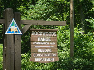
Rockwoods Range Conservation Area
Distance: Approx. 6968 meters
Latitude and longitude: 38.519685,-90.691557
Rockwoods Range Conservation Area consists of 1,388 acres (5.62 km2) in western St. Louis County, Missouri. It is just north of Interstate 44 west of Eureka.
Lake Tekakwitha, Missouri
Village in Missouri, United States
Distance: Approx. 7260 meters
Latitude and longitude: 38.44138889,-90.71527778
Lake Tekakwitha is a village in Jefferson County, Missouri, United States. The population was 254 in 2010.

Red Cedar Inn
United States historic place
Distance: Approx. 4302 meters
Latitude and longitude: 38.4817,-90.7177
The Red Cedar Inn is a historic former inn located in Pacific, Missouri along the U.S. Route 66. Opened shortly after the construction of Route 66 in Pacific and repeal of Prohibition, the Red Cedar Inn provided a significant economic boost to the city. In 1932, Route 66 reached Pacific, and the town got an economic boost.
Calvey Creek
Stream in the American state of Missouri
Distance: Approx. 6970 meters
Latitude and longitude: 38.43833333,-90.80111111
Calvey Creek is a stream in Franklin and Jefferson counties in the U.S. state of Missouri. It is a tributary to the Meramec River. The stream headwaters are in Jefferson County at 38°17′39″N 90°45′10″W and the confluence with the Meramec in Franklin County is at 38°26′18″N 90°48′04″W. The source area for the stream lies south of Missouri Route 30 north of Grubville in Jefferson County and the stream flows north along the county line before turning northwest passing under Route HH. The stream forms the east boundary of Robertsville State Park west of Catawissa and meets the Meramec at the northeast corner of the park.
Oetters, Missouri
Unincorporated community in Missouri, U.S.
Distance: Approx. 7277 meters
Latitude and longitude: 38.55527778,-90.79361111
Oetters is an unincorporated community in Franklin County, in the U.S. state of Missouri. The community sits above the Missouri River floodplain along Missouri Route T. Fiddle Creek passes adjacent to the community as it enters the Missouri River floodplain. The community most likely has the name of Henry Oeters, original owner of the site.
Winch Creek
Stream in the American state of Missouri
Distance: Approx. 5521 meters
Latitude and longitude: 38.445,-90.75472222
Winch Creek is a stream in eastern Franklin County in the U.S. state of Missouri. Winch Creek is a tributary to the Meramec River. The stream headwaters are at 38°24′17″N 90°44′50″W and the confluence with the Meramec is at 38°26′42″N 90°45′17″W. The source area is adjacent to the eastern border of the county and the stream flows north parallel to the border for about one mile and then turns to the west and flows roughly parallel to Missouri Route O for two miles to the community of Catawissa.
Boles Township, Franklin County, Missouri
Township in Franklin County, Missouri, U.S.
Distance: Approx. 4992 meters
Latitude and longitude: 38.5042,-90.8203
Boles Township is an inactive township in Franklin County, in the U.S. state of Missouri. Boles Township was established in 1821, taking its name from Ambrose Boles, a pioneer citizen.
Meramec Valley School District
School district in Missouri
Distance: Approx. 1473 meters
Latitude and longitude: 38.48305556,-90.755
Meramec Valley R-III School District is a school district serving portions of Franklin County, Jefferson County, and St. Louis County.
Weather in this IP's area
clear sky
-0 Celsius
-3 Celsius
-2 Celsius
1 Celsius
1027 hPa
80 %
1027 hPa
1004 hPa
10000 meters
2.06 m/s
5.02 m/s
259 degree
6 %

