Country:
 USA
USARegion:
City:
Latitude and Longitude:
Time Zone:
Postal Code:
IP information under different IP Channel
ip-api
Country
Region
City
ASN
Time Zone
ISP
Blacklist
Proxy
Latitude
Longitude
Postal
Route
IPinfo
Country
Region
City
ASN
Time Zone
ISP
Blacklist
Proxy
Latitude
Longitude
Postal
Route
MaxMind
Country
Region
City
ASN
Time Zone
ISP
Blacklist
Proxy
Latitude
Longitude
Postal
Route
Luminati
Country
USRegion
ct
City
stamford
ASN
Time Zone
America/New_York
ISP
CLOUDPATH
Latitude
Longitude
Postal
db-ip
Country
Region
City
ASN
Time Zone
ISP
Blacklist
Proxy
Latitude
Longitude
Postal
Route
ipdata
Country
Region
City
ASN
Time Zone
ISP
Blacklist
Proxy
Latitude
Longitude
Postal
Route
Popular places and events near this IP address

Stamford Hospital
Hospital in Connecticut, United States
Distance: Approx. 1081 meters
Latitude and longitude: 41.055,-73.5525
Stamford Hospital, residing on the Bennett Medical Center campus, is a 305-bed, not-for-profit hospital and the central facility for Stamford Health. The hospital is regional healthcare facility for Fairfield and Westchester counties, and is the only hospital in the city of Stamford, Connecticut. Stamford Hospital is the largest teaching affiliate of the Columbia University Vagelos College of Physicians & Surgeons outside of NewYork-Presbyterian/Columbia University Irving Medical Center (NYP/CUIMC).

Octagon House (Stamford, Connecticut)
Historic house in Connecticut, United States
Distance: Approx. 1056 meters
Latitude and longitude: 41.06396944,-73.53541389
The Octagon House was a historic house at 120 Strawberry Hill Avenue, on the edge of the Glenbrook section of Stamford, Connecticut. It was one of a number of octagon houses in the United States, built during a fad in buildings of that shape from the late 1840s to the 1870s. The octagonal portion of the house was concrete, with external scoring to imitate ashlar.
J. M. Wright Technical High School
High school in Connecticut, United States
Distance: Approx. 263 meters
Latitude and longitude: 41.0618,-73.5473
J.M. Wright Technical High School, or Wright Tech, is a technical high school located in Stamford, Connecticut, United States. It is part of the Connecticut Technical High School System. Having suspended operations in 2009 due to budgetary restrictions, Wright Tech reopened its doors in 2014 to 144 first-year students after undergoing an $85 million renovation.

Fish Church
United States historic place
Distance: Approx. 797 meters
Latitude and longitude: 41.06305556,-73.53861111
The First Presbyterian Church of Stamford is a church in Stamford, Connecticut designed by architect Wallace K. Harrison. Nicknamed the Fish Church for its unusual shape. The interior of the church contains a shimmering stained glass 60-foot-tall (18 m) nave.

St. Andrew's Episcopal Church (Stamford, Connecticut)
Historic church in Connecticut, United States
Distance: Approx. 907 meters
Latitude and longitude: 41.05720833,-73.54222778
St. Andrew's Episcopal Church is a historic church at 1231 Washington Boulevard in Stamford, Connecticut. Built in 1860 and consecrated on May 8, 1861, Saint Andrew's Church was originally a mission of St.

C. J. Starr Barn and Carriage House
United States historic place
Distance: Approx. 1155 meters
Latitude and longitude: 41.0675,-73.535
The C. J. Starr Barn and Carriage House is an historic estate outbuilding, located on the grounds of the former Sacred Heart Academy on Strawberry Hill Road in Stamford, Connecticut. It is a large 1+1⁄2-story wood-frame structure with elegant Italianate scrolled woodwork on the exterior, with a smaller barn joined to a larger building that originally functioned as a carriage house. They were built c.
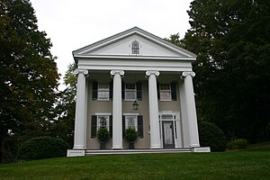
Josiah Wilcox House
Historic house in Connecticut, United States
Distance: Approx. 824 meters
Latitude and longitude: 41.06222222,-73.5575
The Josiah Wilcox House is a historic house at 354 Riversville Road in Greenwich, Connecticut. Built in 1838, it is one of the town's finest examples of Greek Revival architecture. It was listed on the National Register of Historic Places in 1988.
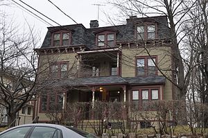
Linden Apartments
United States historic place
Distance: Approx. 521 meters
Latitude and longitude: 41.06,-73.545
The Linden Apartments are a historic multiunit apartment house at 10–12 Linden Pl. in Stamford, Connecticut. It is a 2+1⁄2-story wood-frame Second Empire style building with a mansard roof, and projecting window bays.

Revonah Manor Historic District
Historic district in Connecticut, United States
Distance: Approx. 690 meters
Latitude and longitude: 41.06777778,-73.54138889
The Revonah Manor Historic District is a 23.1-acre (9.3 ha) predominantly residential historic district in Stamford, Connecticut that was listed on the National Register of Historic Places in 1986. The district encompasses what was one of Stamford's first planned residential developments, developed by Herman Henneberg and his son-in-law Henry Jevne, with many houses designed by Lawrence Barnard. The result was a remarkable concentration of fairly uniformly-designed Colonial Revival and Tudor Revival houses in a three-block area.

Mill River Park
Park in Stamford, Connecticut, US
Distance: Approx. 1066 meters
Latitude and longitude: 41.0547,-73.5456
Mill River Park is a 12-acre urban park located in downtown Stamford, Connecticut. The park, which separates Downtown from the West Side, features a restored section of the Mill River, extensive landscaping, and various recreational amenities. It is the result of a long-term redevelopment project aimed at reclaiming green space and improving the ecological health of the area.
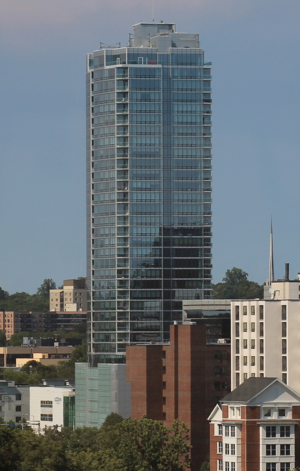
Park Tower Stamford
Skyscraper in Connecticut
Distance: Approx. 1063 meters
Latitude and longitude: 41.055363,-73.542898
Park Tower Stamford (formerly known as Trump Parc Stamford, and temporarily as Parc Stamford) is a 36-story condominium property located at 1 Broad Street in Stamford, Connecticut. Real estate developers Thomas Rich and Louis R. Cappelli began planning the project as Park Tower in February 2006; it was renamed as Trump Parc Stamford later that year, after Donald Trump joined the project, and again renamed Park Tower Stamford. Trump Parc was initially rejected by the city, as it was considered too large for its 0.5-acre (0.20 ha) site.
Ridgeway Shopping Center
Shopping mall in Stamford, Connecticut
Distance: Approx. 466 meters
Latitude and longitude: 41.0678,-73.5454
Ridgeway Shopping Center is a 365,411 sq ft (33,947.8 m2) shopping center in Stamford, Connecticut, now classifying as a power center but when first opened in 1947, the first department store-anchored suburban shopping center in the Eastern United States. Stamford designer and architect Alfons Bach planned the initial section of the center in 1946, which opened on March 26, 1947, with 110,000 sq ft (10,000 m2) of retail space on a 20,000-square-foot (1,900 m2) parcel. Initial tenants included W.J. Sloan Home Furnishings (October 1948), Pennsylvania Drug (May 1949), Deena's, The Lurie Company, Chizzini and a Slenderella Figure Salon.
Weather in this IP's area
overcast clouds
20 Celsius
20 Celsius
19 Celsius
22 Celsius
1016 hPa
81 %
1016 hPa
1015 hPa
10000 meters
4.92 m/s
4.92 m/s
35 degree
100 %
06:38:10
18:58:18