216.247.98.85 - IP Lookup: Free IP Address Lookup, Postal Code Lookup, IP Location Lookup, IP ASN, Public IP
Country:
 USA
USARegion:
City:
Location:
Time Zone:
Postal Code:
ISP:
ASN:
language:
User-Agent:
Proxy IP:
Blacklist:
IP information under different IP Channel
ip-api
Country
Region
City
ASN
Time Zone
ISP
Blacklist
Proxy
Latitude
Longitude
Postal
Route
db-ip
Country
Region
City
ASN
Time Zone
ISP
Blacklist
Proxy
Latitude
Longitude
Postal
Route
IPinfo
Country
Region
City
ASN
Time Zone
ISP
Blacklist
Proxy
Latitude
Longitude
Postal
Route
IP2Location
216.247.98.85Country
usRegion
texas
City
aldine
Time Zone
America/Chicago
ISP
Language
User-Agent
Latitude
Longitude
Postal
ipdata
Country
Region
City
ASN
Time Zone
ISP
Blacklist
Proxy
Latitude
Longitude
Postal
Route
Popular places and events near this IP address

Aldine, Texas
Place in Texas, United States
Distance: Approx. 1474 meters
Latitude and longitude: 29.91916667,-95.37972222
Aldine ( AWL-deen) is a census-designated place (CDP) in unincorporated central Harris County, Texas, United States, located within the extraterritorial jurisdiction of Houston. The population was 15,999 at the 2020 census. The community is located on the Hardy Toll Road, Union Pacific Railroad, and Farm to Market Road 525.

Aldine Independent School District
School district in Texas, United States
Distance: Approx. 2365 meters
Latitude and longitude: 29.93472222,-95.35583333
The Aldine Independent School District is a public school district based in unincorporated Harris County, Texas, United States. It serves portions of Houston and unincorporated Harris County. Aldine ISD serves the communities of Aldine, most of Greenspoint, most of East Aldine, and portions of Airline, Acres Homes, Kinwood, Bordersville, and Inwood Forest.

Greenspoint, Houston
Neighborhood and business district in Harris County, Texas, United States
Distance: Approx. 3001 meters
Latitude and longitude: 29.94694444,-95.40638889
Greater Greenspoint, also referred to as the North Houston District, is a 7-square-mile (18 km2) business district and a suburban neighborhood in northern Harris County, Texas, United States, located mostly within the city limits of Houston. Centered around the junction of Interstate 45 and Texas State Highway Beltway 8 near George Bush Intercontinental Airport, the area is a classic example of a planned edge city. The initial 2,000-acre (8.1 km2) retail and office development centered around Greenspoint Mall was a project of the Friendswood Development Company during the 1970s and early 1980s.
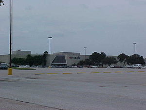
Greenspoint Mall
Shopping mall in Texas, United States
Distance: Approx. 3370 meters
Latitude and longitude: 29.94555556,-95.41166667
Greenspoint Mall was a shopping mall located in the Greenspoint neighborhood of Houston, Texas, at the northeast corner of Interstate 45 and Beltway 8 (also known as the Sam Houston Parkway/Tollway). The only remaining anchor is Fitness Connection, which occupies half of the former Lord & Taylor/Mervyn's store on the west side of the mall. There are 6 vacant anchor pads on the site that were once occupied by Macy's, Foley's, Palais Royal, Dillard's, Sears, Premiere Cinemas, JCPenney, Lord & Taylor, Mervyn's, and Montgomery Ward.

Campbell Center
Building in Houston, Texas, United States
Distance: Approx. 1976 meters
Latitude and longitude: 29.93222222,-95.35972222
The M.O. Campbell Educational Center is an indoor arena in Houston, Texas. The facility serves as the home basketball and volleyball court for the five high schools in the Aldine Independent School District (AISD). The Campbell Center is also used for graduations, theatrical performances, meetings, conferences, banquets and community events.

Houston Air Route Traffic Control Center
Distance: Approx. 5674 meters
Latitude and longitude: 29.9615,-95.3319
Houston Air Route Traffic Control Center (ZHU) is located at George Bush Intercontinental Airport at 16600 JFK Boulevard, Houston, Texas, United States 77032. The Houston ARTCC is one of 22 Air Route Traffic Control Centers in the United States. Houston Center is the 9th busiest ARTCC in the United States.

Aldine High School
Public school in Texas, United States
Distance: Approx. 3230 meters
Latitude and longitude: 29.91666667,-95.40833333
Aldine Senior High School is a public high school located in the Greenspoint district of northern Houston, Texas, United States. It is part of the Aldine Independent School District. The senior high school campus serves grades 10 through 12 (although a few ninth grade students attend select classes at Aldine High).
East Aldine, Texas
State management district in Texas, US
Distance: Approx. 5044 meters
Latitude and longitude: 29.8998,-95.3439
East Aldine is a state management district in Harris County, Texas, United States, mostly in unincorporated areas, with some territory in the City of Houston. The East Aldine Improvement District, also known as the Aldine Management District, governs the area. Portions of the district coincide with the boundaries of the Aldine census-designated place.
Airline, Texas
Distance: Approx. 5239 meters
Latitude and longitude: 29.88658,-95.392605
The Airline Improvement District is a management district in unincorporated Harris County, Texas, United States, in Greater Houston and is located entirely within the postal zip code of 77037. Airline was originally a community, south of the community of Stuebner and west of the town of Aldine. The name appears on the 1907 postal map for Harris County.

W.W. Thorne Stadium
Distance: Approx. 1846 meters
Latitude and longitude: 29.932306,-95.36106
W.W. Thorne Stadium, an American football and soccer venue, is the home stadium of the Aldine Independent School District's (Aldine ISD) five varsity high school football teams - the Aldine Mustangs, Davis Falcons, Eisenhower Eagles, MacArthur Generals and Nimitz Cougars of District 18-6A, as well as for each schools' varsity boys and girls soccer teams. Thorne Stadium is located in north Houston, Texas, on Aldine-Bender Road just south of Beltway 8, a short distance from George Bush Intercontinental Airport and Greenspoint Mall. It is part of the Aldine ISD Athletic Complex, which includes Thorne Stadium, the M.O. Campbell Center for basketball and volleyball, Elliott Lansford Field for baseball, and the Aldine ISD Softball Complex for softball.
Benjamin O. Davis High School
Public school in Texas, United States
Distance: Approx. 5666 meters
Latitude and longitude: 29.95457,-95.43308
Benjamin O. Davis High School is a public high school located in unincorporated Harris County, Texas, USA, near Houston, and a part of the Aldine Independent School District. It is classified as a 6A school by the UIL. In 2019, the school received a C grade from the Texas Education Agency.
Radiant Fountains
Sculpture by Dennis Oppenheim in Houston, Texas, U.S.
Distance: Approx. 5712 meters
Latitude and longitude: 29.967288,-95.336777
Radiant Fountains is a 2010 sculpture by Dennis Oppenheim, installed outside Houston's George Bush Intercontinental Airport, in the U.S. state of Texas.
Weather in this IP's area
overcast clouds
26 Celsius
26 Celsius
26 Celsius
27 Celsius
1017 hPa
74 %
1017 hPa
1013 hPa
10000 meters
4.63 m/s
200 degree
100 %