Country:
 USA
USARegion:
City:
Latitude and Longitude:
Time Zone:
Postal Code:
IP information under different IP Channel
ip-api
Country
Region
City
ASN
Time Zone
ISP
Blacklist
Proxy
Latitude
Longitude
Postal
Route
IPinfo
Country
Region
City
ASN
Time Zone
ISP
Blacklist
Proxy
Latitude
Longitude
Postal
Route
MaxMind
Country
Region
City
ASN
Time Zone
ISP
Blacklist
Proxy
Latitude
Longitude
Postal
Route
Luminati
Country
USRegion
vt
City
plainfield
ASN
Time Zone
America/New_York
ISP
TVC-AS1
Latitude
Longitude
Postal
db-ip
Country
Region
City
ASN
Time Zone
ISP
Blacklist
Proxy
Latitude
Longitude
Postal
Route
ipdata
Country
Region
City
ASN
Time Zone
ISP
Blacklist
Proxy
Latitude
Longitude
Postal
Route
Popular places and events near this IP address
Plainfield, Vermont
Town in Vermont, United States
Distance: Approx. 1709 meters
Latitude and longitude: 44.25444444,-72.41027778
Plainfield, a town in Washington County, Vermont, United States was incorporated in 1867. The population was 1,236 at the 2020 census. Plainfield is the location of Goddard College.

Goddard College
Private liberal arts college in Vermont, United States
Distance: Approx. 1873 meters
Latitude and longitude: 44.2789,-72.4394
Goddard College was a private college with three locations in the United States: Plainfield, Vermont; Port Townsend, Washington; and Seattle, Washington. The college offered undergraduate and graduate degree programs. With predecessor institutions dating to 1863, Goddard College was founded in 1938 as an experimental and non-traditional educational institution based on the idea that experience and education are intricately linked.
Washington-6 Vermont Representative District, 2002–2012
Distance: Approx. 4317 meters
Latitude and longitude: 44.3,-72.4
The Washington-6 Representative District is a one-member state Representative district in the U.S. state of Vermont. It is one of the 108 one or two member districts into which the state was divided by the redistricting and reapportionment plan developed by the Vermont General Assembly following the 2000 U.S. Census. The plan applies to legislatures elected in 2002, 2004, 2006, 2008, and 2010.

Plainfield (CDP), Vermont
Census-designated place in Vermont, United States
Distance: Approx. 1325 meters
Latitude and longitude: 44.2775,-72.42444444
Plainfield is a census-designated place (CDP) comprising the main village of the town of Plainfield, Washington County, Vermont, United States. The population of the CDP was 401 at the 2010 census.

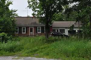
Allenwood Farm
United States historic place
Distance: Approx. 1585 meters
Latitude and longitude: 44.27833333,-72.43388889
The Allenwood Farm is a historic farm property on United States Route 2 in Plainfield, Vermont. Developed in 1827 by Allen Martin, the son of an early settler, it is a well-preserved example of a transitional Federal-Greek Revival detached farmstead. It was listed on the National Register of Historic Places in 1983.
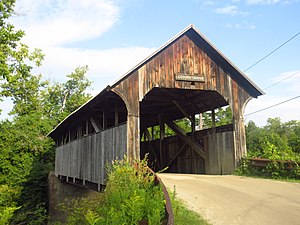
Coburn Covered Bridge
United States historic place
Distance: Approx. 2931 meters
Latitude and longitude: 44.28083333,-72.455
The Coburn Covered Bridge is a historic covered bridge, carrying Coburn Road over the Winooski River in eastern East Montpelier, Vermont. Built in 1851, it is the town's only surviving 19th-century covered bridge. It was listed on the National Register of Historic Places in 1974.
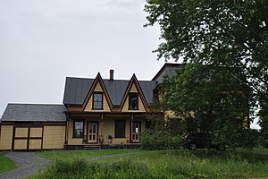
Gale-Bancroft House
Historic house in Vermont, United States
Distance: Approx. 1119 meters
Latitude and longitude: 44.27555556,-72.42305556
The Gale-Bancroft House is a historic house on Brook Road in Plainfield, Vermont. Built about 1840, it is one of a significant number of period brick houses in the town, unusual given the region's typical dependence on wood products for residential construction. It was listed on the National Register of Historic Places in 1984.

Martin Covered Bridge
Wooden bridge in Marshfield, Vermont
Distance: Approx. 2776 meters
Latitude and longitude: 44.2875,-72.40833333
The Martin Covered Bridge is a wooden covered bridge spanning the Winooski River off United States Route 2 in southern Marshfield, Vermont. Built about 1890, it is the only surviving historic covered bridge in the town. It was listed on the National Register of Historic Places in 1974.

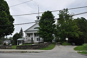
Plainfield Village Historic District
Historic district in Vermont, United States
Distance: Approx. 1449 meters
Latitude and longitude: 44.27861111,-72.42555556
The Plainfield Village Historic District encompasses a significant portion of the village of Plainfield, Vermont. Located in northernmost Plainfield on United States Route 2 (and extending a shortway into adjacent Marshfield), the village grew in the 19th century as a mill town and service community for the surround agricultural areas, and has a well-preserved collection of Greek Revival and Italianate architecture. It was listed on the National Register of Historic Places in 1983.
Theodore Wood House
Historic house in Vermont, United States
Distance: Approx. 4137 meters
Latitude and longitude: 44.30194444,-72.41416667
The Theodore Wood House is a historic house at 1420 Hollister Hill Road in Marshfield, Vermont. Built about 1887, it is the only known surviving work of Chester James Wood, a local builder of some reputation, and is the town's only significant surviving example of Second Empire architecture. It was listed on the National Register of Historic Places in 2005.
North Montpelier, Vermont
Village in Vermont, United States
Distance: Approx. 4562 meters
Latitude and longitude: 44.30361111,-72.44638889
North Montpelier is an unincorporated village in the town of East Montpelier, Washington County, Vermont, United States. The community is located at the junction of Vermont routes 14 and 214, 7 miles (11 km) east-northeast of Montpelier.

Marshfield School of Weaving
Craft school in Marshfield, Vermont
Distance: Approx. 4405 meters
Latitude and longitude: 44.30337,-72.40852
The Marshfield School of Weaving is a craft school located in Marshfield, Vermont. Instruction focuses on traditional weaving, spinning, dyeing, and other textile techniques from 17th–19th century Britain and North America.
Weather in this IP's area
overcast clouds
12 Celsius
11 Celsius
11 Celsius
12 Celsius
1009 hPa
93 %
1009 hPa
974 hPa
10000 meters
2.06 m/s
190 degree
100 %
06:21:21
19:13:26