216.234.60.204 - IP Lookup: Free IP Address Lookup, Postal Code Lookup, IP Location Lookup, IP ASN, Public IP
Country:
 Canada
Region:
City:
Location:
Time Zone:
Postal Code:
ISP:
ASN:
language:
User-Agent:
Proxy IP:
Blacklist:
IP information under different IP Channel
ip-api
Country
Region
City
ASN
Time Zone
ISP
Blacklist
Proxy
Latitude
Longitude
Postal
Route
db-ip
Country
Region
City
ASN
Time Zone
ISP
Blacklist
Proxy
Latitude
Longitude
Postal
Route
IPinfo
Country
Region
City
ASN
Time Zone
ISP
Blacklist
Proxy
Latitude
Longitude
Postal
Route
IP2Location
216.234.60.204Country
caRegion
ontario
City
niagara falls
Time Zone
America/Toronto
ISP
Language
User-Agent
Latitude
Longitude
Postal
ipdata
Country
Region
City
ASN
Time Zone
ISP
Blacklist
Proxy
Latitude
Longitude
Postal
Route
Popular places and events near this IP address
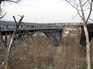
Whirlpool Rapids Bridge
Bridge in Ontario and New York
Distance: Approx. 1533 meters
Latitude and longitude: 43.109208,-79.058336
The Whirlpool Rapids Bridge, commonly known as the Whirlpool Bridge or the Lower Steel Arch Bridge (before 1937), is a spandrel braced, riveted, two-hinged arch bridge that crosses the Canada–United States border, connecting the commercial downtown districts of Niagara Falls, Ontario, and Niagara Falls, New York. This bridge is located approximately 1.5 kilometres (0.9 mi) north of the Rainbow Bridge and about 2 kilometres (1.2 mi) from the Falls. It was acquired by the Niagara Falls Bridge Commission in January 1959.

Whirlpool Aero Car
Cable car in Niagara, Ontario
Distance: Approx. 390 meters
Latitude and longitude: 43.11798,-79.06877
The Whirlpool Aero Car or Spanish Aero Car is a cable car located in Niagara Falls, Ontario that transports passengers over a section of the Niagara River referred to as the Niagara Whirlpool. The system was designed by Spanish engineer Leonardo Torres Quevedo and has been upgraded several times since 1916 (in 1961, 1967 and 1984). The system uses one car that carries 35 standing passengers over a one-kilometre trip.

Whirlpool State Park
State park in Niagara County, New York
Distance: Approx. 1017 meters
Latitude and longitude: 43.117,-79.061
Whirlpool State Park is a 109-acre (0.44 km2) state park located in Niagara County, New York, north of the city of Niagara Falls. The park overlooks the Niagara Whirlpool on the Niagara River and the lower Niagara Gorge.

Niagara Gorge
Canyon on the border between New York, USA and Ontario, Canada
Distance: Approx. 451 meters
Latitude and longitude: 43.12083333,-79.07055556
Niagara Gorge is an 11 km (6.8 mi) long canyon carved by the Niagara River along the Canada–United States border, between the U.S. state of New York and the Canadian province of Ontario. It begins at the base of Niagara Falls and ends downriver at the edge of the geological formation known as the Niagara Escarpment near Queenston, Ontario, where the falls originated about 12,500 years ago. The position of the falls has receded upstream toward Lake Erie because of the falling waters' slow erosion of the riverbed's hard Lockport dolomite (a form of limestone that is the surface rock of the escarpment), combined with rapid erosion of the relatively soft layers beneath it.

Niagara Falls Suspension Bridge
Defunct bridge spanning the Niagara River
Distance: Approx. 1536 meters
Latitude and longitude: 43.10916667,-79.05833333
The Niagara Falls Suspension Bridge stood from 1855 to 1897 across the Niagara River and was the world's first working railway suspension bridge. It spanned 825 feet (251 m) and stood 2.5 miles (4.0 km) downstream of Niagara Falls, where it connected Niagara Falls, Ontario to Niagara Falls, New York. Trains used the upper of its two decks, while pedestrians and carriages used the lower.

Niagara Falls station (Ontario)
Railway station in Niagara Falls, Canada
Distance: Approx. 1261 meters
Latitude and longitude: 43.1088,-79.0634
Niagara Falls station is an international railway station in Niagara Falls, Ontario, Canada. It is served by the Maple Leaf train between Toronto and New York City and is the terminus of GO Transit's Lakeshore West line towards Toronto. The Gothic Revival station building, which was built in 1879 by the Great Western Railway, is a designated heritage railway station.

De Veaux Woods State Park
State park in Niagara County, New York
Distance: Approx. 1172 meters
Latitude and longitude: 43.11861111,-79.05916667
De Veaux Woods State Park is a 51-acre (0.21 km2) state park located in Niagara County, New York, USA. The park is located off the Niagara Scenic Parkway, north of the City of Niagara Falls. It is adjacent to Whirlpool State Park.
Queen Street Arts and Culture District
Distance: Approx. 1311 meters
Latitude and longitude: 43.106623,-79.066994
The Queen Street Arts and Culture District is the old downtown area of Niagara Falls, Ontario, Canada. The street is now populated with art galleries, restaurants, and performing spaces. Home to one of the Niagara Region's largest Festival, Springlicious.

Deveaux School Historic District
Historic district in New York, United States
Distance: Approx. 1135 meters
Latitude and longitude: 43.12,-79.06
Deveaux School Historic District is a national historic district located at Niagara Falls in Niagara County, New York.

Niagara Falls Transit Terminal
Distance: Approx. 1314 meters
Latitude and longitude: 43.10805556,-79.06361111
Niagara Falls Transit Terminal is located south of Bridge Street on Erie Avenue in Niagara Falls, Ontario, Canada, directly across from the Niagara Falls railway station.

Niagara Whirlpool
Natural whirlpool in the Niagara Gorge, downstream from Niagara Falls
Distance: Approx. 477 meters
Latitude and longitude: 43.120783,-79.069891
The Niagara Whirlpool is a natural whirlpool within the Niagara River located along the Canada–U.S. border between New York and Ontario. The whirlpool is in the Niagara Gorge (a gorge on that border), downstream from Niagara Falls (a group of three waterfalls on that border). The whirlpool's greatest depth is 125 feet (38 m).

Gale Centre
Arena in Niagara Falls, Ontario
Distance: Approx. 712 meters
Latitude and longitude: 43.11361111,-79.08055556
Gale Centre is a four rink ice complex containing a 2,170 seat arena located in Niagara Falls, Ontario. It was built on the site of the demolished Cyanamid Niagara plant.
Weather in this IP's area
overcast clouds
-10 Celsius
-17 Celsius
-11 Celsius
-9 Celsius
1028 hPa
80 %
1028 hPa
1009 hPa
10000 meters
3.78 m/s
7.79 m/s
99 degree
100 %