216.234.58.21 - IP Lookup: Free IP Address Lookup, Postal Code Lookup, IP Location Lookup, IP ASN, Public IP
Country:
Region:
City:
Location:
Time Zone:
Postal Code:
IP information under different IP Channel
ip-api
Country
Region
City
ASN
Time Zone
ISP
Blacklist
Proxy
Latitude
Longitude
Postal
Route
Luminati
Country
ASN
Time Zone
America/Toronto
ISP
ACI-1
Latitude
Longitude
Postal
IPinfo
Country
Region
City
ASN
Time Zone
ISP
Blacklist
Proxy
Latitude
Longitude
Postal
Route
IP2Location
216.234.58.21Country
Region
ontario
City
mississauga
Time Zone
America/Toronto
ISP
Language
User-Agent
Latitude
Longitude
Postal
db-ip
Country
Region
City
ASN
Time Zone
ISP
Blacklist
Proxy
Latitude
Longitude
Postal
Route
ipdata
Country
Region
City
ASN
Time Zone
ISP
Blacklist
Proxy
Latitude
Longitude
Postal
Route
Popular places and events near this IP address

Bramalea GO Station
Railway station in Ontario, Canada
Distance: Approx. 2908 meters
Latitude and longitude: 43.70194444,-79.69111111
Bramalea GO Station is a GO Transit railway and bus station along the Kitchener line in Brampton, Ontario, Canada. It is located at 1713 Steeles Avenue East, near the community of Bramalea at Steeles Avenue East and Bramalea Road. In addition to the Kitchener line train service, it is also served by numerous GO Transit, Brampton Transit bus routes, as well as one MiWay bus route.

Mississauga—Brampton South
Federal electoral district in Ontario, Canada
Distance: Approx. 3231 meters
Latitude and longitude: 43.7,-79.7
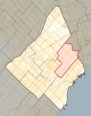
Mississauga—Brampton South was a federal electoral district in Ontario, Canada, that was represented in the House of Commons of Canada from 2004 to 2015. It consists of the parts of the cities of Mississauga and Brampton bounded by a line drawn from the intersection of Highway 401 with the northeastern limit of the City of Mississauga, south along the city limit, southwest along Burnhamthorpe Road East, northwest along Central Parkway East, southwest along Highway 403, northwest along Mavis Road; thence northwesterly along said road to Eglinton Avenue West; thence southwesterly along said avenue to Terry Fox Way; thence northwesterly along said way to Britannia Road West; thence northeasterly along said road to Mavis Road, southwest along Highway 401, northwest along Mississauga Road, northeast along the northwestern limit of the City of Mississauga, northwest along McLaughlin Road, northeast along Steeles Avenue East, southeast along Kennedy Road South, northeast along the northwestern limit of the City of Mississauga, southeast along Dixie Road, and northeast along Highway 401 to the point of commencement. Following the 2012 federal electoral boundaries redistribution, the bulk of the district will be part of the new Mississauga—Malton district, with other parts transferred to Mississauga East—Cooksville, Mississauga Centre, Mississauga—Streetsville, Brampton South, and Brampton Centre.

CAA Centre
Arena in Brampton, Ontario, Canada
Distance: Approx. 3478 meters
Latitude and longitude: 43.66701,-79.70866
The CAA Centre (formerly the Brampton Centre for Sports & Entertainment and the Powerade Centre) is a 5,000-seat multi-purpose arena in Brampton, Ontario, Canada. It was built in 1998, and officially opened the same year on October 7. In 2023, the arena became home to the Brampton Honey Badgers of the Canadian Elite Basketball League.

Toronto Pearson International Airport
Airport in Malton, Ontario, Canada
Distance: Approx. 3201 meters
Latitude and longitude: 43.67666667,-79.63055556
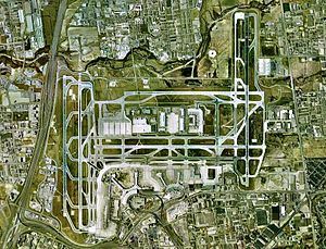
Toronto Pearson International Airport (IATA: YYZ, ICAO: CYYZ) is an international airport located in Mississauga, with a small portion of the airfield, along Silver Dart Drive north of Renforth Drive, extending into Toronto's western district of Etobicoke, Ontario, Canada. It is the main airport serving Toronto, its metropolitan area, and the surrounding region known as the Golden Horseshoe. The airport is named in honour of Lester B. Pearson, who served as the 14th Prime Minister of Canada (1963–1968) and received the Nobel Peace Prize in 1957 for his humanitarian work in peacekeeping.

Ontario Khalsa Darbar
Gurdwara in Mississauga, Ontario
Distance: Approx. 766 meters
Latitude and longitude: 43.6767,-79.67754
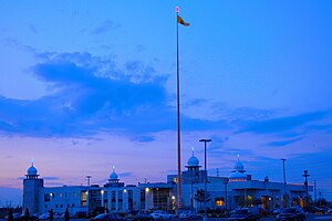
The Ontario Khalsa Darbar, popularly referred to as Dixie Gurdwara, is a Sikh Gurdwara (place of worship) in Mississauga, Ontario. One of the few Sikh Gurdwara in Canada, it attracts hundreds of celebrants for major religious festivals. A gurdwara, meaning "the doorway to the Guru", is the Sikh place of worship and may be referred to as a Sikh temple.

International Centre
Distance: Approx. 3556 meters
Latitude and longitude: 43.7029,-79.638
The International Centre is a multi-purpose convention centre in Mississauga, Ontario, Canada, located near Toronto Pearson International Airport. The International Centre is privately owned and hosts over 450 shows and events each year.
Toronto Area Control Centre
Airport
Distance: Approx. 3575 meters
Latitude and longitude: 43.67159683,-79.62736083
Toronto Area Control Center (ICAO: CZYZ) is one of seven area control centers in Canada operated by Nav Canada. The Toronto Area Control Centre is based near Toronto Pearson International Airport in Mississauga, Ontario. From the Toronto Area Control Centre, air traffic controllers provide en route and terminal control services to aircraft in the Toronto Flight Information Region (FIR).

Mississauga East—Cooksville (provincial electoral district)
Provincial electoral district in Ontario, Canada
Distance: Approx. 3231 meters
Latitude and longitude: 43.7,-79.7
Mississauga East—Cooksville is a provincial electoral district in Ontario, Canada, that has been represented in the Legislative Assembly of Ontario since the 2007 provincial election.
Mississauga Cogeneration Plant
Distance: Approx. 2925 meters
Latitude and longitude: 43.69805556,-79.6425
Mississauga Cogeneration Plant was a natural gas power station partially owned by TransAlta and located adjacent to Toronto Pearson International Airport. The plant was primarily used to supply steam and power to nearby industrial clients with surplus power sold onto the Ontario grid. From 1992 to 2007, it supplied thermal energy to the McDonnell Douglas and later Boeing aircraft parts plant.

Mississauga—Malton (federal electoral district)
Federal electoral district in Ontario, Canada
Distance: Approx. 2981 meters
Latitude and longitude: 43.655,-79.66
Mississauga—Malton is a federal electoral district in Ontario. It encompasses a portion of Ontario previously included in the electoral districts of Bramalea—Gore—Malton, Mississauga—Brampton South and Mississauga—Streetsville. Mississauga—Malton was created by the 2012 federal electoral boundaries redistribution and was legally defined in the 2013 representation order.

Mississauga—Malton (provincial electoral district)
Provincial electoral district in Ontario, Canada
Distance: Approx. 2981 meters
Latitude and longitude: 43.655,-79.66
Mississauga—Malton is a provincial electoral district in Ontario, Canada. It elects one member to the Legislative Assembly of Ontario. This riding was created in 2015.

Toronto Pearson International Airport heist
2023 Canadian heist
Distance: Approx. 3201 meters
Latitude and longitude: 43.67666667,-79.63055556
On April 17, 2023, a major theft occurred at Toronto Pearson International Airport in Canada, with over C$20 million (US$15 million) worth of gold and cash in foreign currency being stolen. In the evening of Monday, April 17, a container which contained goldbars and foreign currency was offloaded off an inbound aircraft and transferred to an Air Canada holding facility at the airport where Air Canada staff were tricked by a forged shipping document to load it onto a getaway truck. Nine people have been charged in relation to the heist.
Weather in this IP's area
broken clouds
-7 Celsius
-14 Celsius
-8 Celsius
-7 Celsius
1020 hPa
59 %
1020 hPa
995 hPa
10000 meters
6.69 m/s
320 degree
75 %