216.234.50.217 - IP Lookup: Free IP Address Lookup, Postal Code Lookup, IP Location Lookup, IP ASN, Public IP
Country:
 Canada
Region:
City:
Location:
Time Zone:
Postal Code:
ISP:
ASN:
language:
User-Agent:
Proxy IP:
Blacklist:
IP information under different IP Channel
ip-api
Country
Region
City
ASN
Time Zone
ISP
Blacklist
Proxy
Latitude
Longitude
Postal
Route
db-ip
Country
Region
City
ASN
Time Zone
ISP
Blacklist
Proxy
Latitude
Longitude
Postal
Route
IPinfo
Country
Region
City
ASN
Time Zone
ISP
Blacklist
Proxy
Latitude
Longitude
Postal
Route
IP2Location
216.234.50.217Country
caRegion
ontario
City
woodstock
Time Zone
America/Toronto
ISP
Language
User-Agent
Latitude
Longitude
Postal
ipdata
Country
Region
City
ASN
Time Zone
ISP
Blacklist
Proxy
Latitude
Longitude
Postal
Route
Popular places and events near this IP address

Woodstock, Ontario
City in Ontario, Canada
Distance: Approx. 747 meters
Latitude and longitude: 43.13055556,-80.74666667
Woodstock is a city in Southwestern Ontario, Canada. The city has a population of 46,705 according to the 2016 Canadian census. Woodstock is the seat of Oxford County, at the head of the Thames River, approximately 128 km from Toronto, and 43 km from London, Ontario.

CKDK-FM
Radio station in Woodstock, Ontario
Distance: Approx. 3247 meters
Latitude and longitude: 43.10222222,-80.77055556
CKDK-FM is a Canadian radio station owned by Corus Entertainment, and is licensed to the city of Woodstock, Ontario. It serves the London market, with transmitter power of 51,000 watts on the assigned frequency of 103.9 MHz, covering most of Southwestern Ontario. The station airs a country format branded as Country 104.
Woodstock (Norm Beckham/Bob Hewitt Field) Aerodrome
Airport in Woodstock, Ontario
Distance: Approx. 5724 meters
Latitude and longitude: 43.10972222,-80.82083333
Woodstock (Norm Beckham/Bob Hewitt Field) Aerodrome (TC LID: CPR5) is located 2.5 nautical miles (4.6 km; 2.9 mi) west of Woodstock, Ontario, Canada. The registered aerodrome is home to the Woodstock Ontario Flying Club.
CIHR-FM
Radio station in Woodstock, Ontario
Distance: Approx. 3310 meters
Latitude and longitude: 43.10194444,-80.77166667
CIHR-FM is a Canadian radio station broadcasting at 104.7 FM in Woodstock, Ontario. The station plays an adult contemporary format branded as 104.7 Heart FM and is owned by Byrnes Communications Inc. CIHR also broadcasts HD Radio, with the second subchannel playing music from the 1970s, 1980s and 1990s, as well as Christmas music during the holiday season.
CJFH-FM
Christian radio station in Woodstock, Ontario
Distance: Approx. 3179 meters
Latitude and longitude: 43.10305556,-80.77111111
CJFH-FM is a Canadian radio station, broadcasting at 94.3 FM in Woodstock, Ontario. The station airs a Christian music format branded as Hope FM. The station is owned by Sound of Faith Broadcasting Inc. which was approved by the Canadian Radio-television and Telecommunications Commission to operate a new low-power Christian music FM radio station on May 7, 2003 and officially launched on December 17, 2003 as Faith FM which later changed to Hope FM in 2005.
College Avenue Secondary School
Public school in Woodstock, Ontario, Canada
Distance: Approx. 1038 meters
Latitude and longitude: 43.12376,-80.74543
College Avenue Secondary School is one of three public high schools in Woodstock, Ontario under the Thames Valley District School Board and is named after the street on which it is located. It is built on the site of the former Woodstock College, which closed in 1926. It offers full courses for students in grade 9 through 12.

Woodstock District Community Complex
Distance: Approx. 1707 meters
Latitude and longitude: 43.114267,-80.751572
The Woodstock District Community Complex (now known as the Reeves Community Complex) is considered to be the social epicentre of the Canadian community of Woodstock, Ontario.
Pittock Dam
Dam in Woodstock, Ontario
Distance: Approx. 2197 meters
Latitude and longitude: 43.1487,-80.7607
The Pittock Dam is a dam in Woodstock, Ontario, Canada. It lies on the main branch of the Thames River, and creates the Pittock Reservoir. This artificial lake forms the northeast boundary of the City of Woodstock.
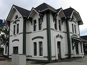
Woodstock station (Ontario)
Railway station in Ontario, Canada
Distance: Approx. 445 meters
Latitude and longitude: 43.12638889,-80.75194444
Woodstock railway station in Woodstock, Ontario, Canada, is a railway station for Via Rail trains running from Toronto west to Windsor. The station is located between Wellington and Bay Streets. Trains are wheelchair accessible (immediate for eastbound passengers but 24 hours' notice required for westbound passengers).

Capitol Theatre (Woodstock, Ontario)
Theatre in Woodstock, Ontario, Canada
Distance: Approx. 425 meters
Latitude and longitude: 43.12969,-80.76091
The Capitol Theatre was located at 385 Dundas St., Woodstock, Ontario, Canada. It was a popular theatre in its day which met its demise after sitting abandoned for many years.

Woodstock Collegiate Institute
Art school in Canada
Distance: Approx. 271 meters
Latitude and longitude: 43.1313,-80.7576
Woodstock Collegiate Institute is a school in Woodstock, Ontario, Canada. It is part of the Thames Valley District School Board. The school was founded in 1841 by an Act of Parliament as Woodstock's first grammar school.
Huron Park Secondary School
High school in Canada
Distance: Approx. 1799 meters
Latitude and longitude: 43.139975,-80.739072
Huron Park Secondary School (HPSS) is a high school in Woodstock, Ontario. It opened in 1955, and has a population of approximately 800 students.
Weather in this IP's area
few clouds
-8 Celsius
-13 Celsius
-11 Celsius
-8 Celsius
1033 hPa
71 %
1033 hPa
993 hPa
10000 meters
2.32 m/s
2.83 m/s
33 degree
22 %