216.234.50.160 - IP Lookup: Free IP Address Lookup, Postal Code Lookup, IP Location Lookup, IP ASN, Public IP
Country:
 Canada
Region:
City:
Location:
Time Zone:
Postal Code:
ISP:
ASN:
language:
User-Agent:
Proxy IP:
Blacklist:
IP information under different IP Channel
ip-api
Country
Region
City
ASN
Time Zone
ISP
Blacklist
Proxy
Latitude
Longitude
Postal
Route
db-ip
Country
Region
City
ASN
Time Zone
ISP
Blacklist
Proxy
Latitude
Longitude
Postal
Route
IPinfo
Country
Region
City
ASN
Time Zone
ISP
Blacklist
Proxy
Latitude
Longitude
Postal
Route
IP2Location
216.234.50.160Country
caRegion
ontario
City
toronto
Time Zone
America/Toronto
ISP
Language
User-Agent
Latitude
Longitude
Postal
ipdata
Country
Region
City
ASN
Time Zone
ISP
Blacklist
Proxy
Latitude
Longitude
Postal
Route
Popular places and events near this IP address

The Beaches, Toronto
Neighbourhood in Toronto, Ontario, Canada
Distance: Approx. 296 meters
Latitude and longitude: 43.667266,-79.297128
The Beaches (also known as "the Beach") is a neighbourhood in Toronto, Ontario, Canada. It is so named because of its four beaches situated on Lake Ontario. It is located east of downtown within the "Old" City of Toronto.

Kew Gardens (Toronto)
Public park in Toronto, Canada
Distance: Approx. 319 meters
Latitude and longitude: 43.668725,-79.298501
Kew Gardens is a large park in The Beaches neighbourhood of Toronto, Ontario, Canada. The park stretches from Queen Street East to Lake Ontario at Kew Beach. The park began as a private 20.7-acre (8.4 ha) farm owned by Joseph Williams in the 1850s.

Church of St. Aidan (Toronto)
Church in Toronto, Ontario
Distance: Approx. 830 meters
Latitude and longitude: 43.672536,-79.28538
The Church of St. Aidan is an Anglican church in The Beaches neighbourhood of Toronto, Ontario, Canada. The church has about 400 members, and approximately 100 people attend on any Sunday.

George Davis House (Toronto)
Distance: Approx. 1063 meters
Latitude and longitude: 43.6748,-79.2839
The George Davis House, is a house in Toronto, Ontario built in 1919 and designated as a Toronto Heritage Property on September 30, 2004. The house is located at 40 Kingswood Road in the Beaches area of eastern Toronto and part of the Kingswood Road South Heritage Conservation District. The house was built for George Davis, an editor with Maclean's Publishing, and was later occupied by F.S. Hollister whose firm was involved in creating the World War 1 memorial windows in Ottawa's Peace Tower on Parliament Hill.

Dr. William D. Young Memorial
Memorial drinking fountain in Toronto, Canada
Distance: Approx. 259 meters
Latitude and longitude: 43.669273,-79.297819
The Dr. William D. Young Memorial is a drinking fountain and memorial that was erected on the eastern border of Kew Gardens in Toronto, Ontario, Canada in August 1920 by residents of the Beaches neighbourhood. The memorial was dedicated to Dr.

The Goof
Distance: Approx. 695 meters
Latitude and longitude: 43.672493,-79.287273
The Goof, officially the Garden Gate Restaurant, is a well known eatery in the Beaches neighbourhood of Toronto. Founded in 1952, it serves Canadian Chinese cuisine as well as diner fare such as breakfast and hamburgers. Its nickname comes from the restaurant's neon sign.

Neville Park Loop
Terminus of Toronto 501 streetcar line
Distance: Approx. 1178 meters
Latitude and longitude: 43.67375,-79.28138889
Neville Park Loop is the eastern terminus of the 301/501 Queen streetcar line, the longest streetcar route of the Toronto Transit Commission (TTC). It is also the terminus of the 143 Beaches/Downtown express bus service. It is located at the southwest corner of Queen Street East and Nursewood Road in the Beaches neighbourhood of Toronto.
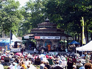
Beaches International Jazz Festival
Music festival in Toronto, Canada
Distance: Approx. 302 meters
Latitude and longitude: 43.66925,-79.29835
The Beaches International Jazz Festival is a month-long music festival held each year in the lakeside Beaches community of Toronto in July. Originally started in 1989, it is now one of Canada's largest free jazz festivals with nearly 1,000,000 attendees, throughout its month-long span. The Festival takes place across a number of venues; stage concerts are held in several different parks within the area and also along a two kilometre stretch of the Beach mainstreet during StreetFest - Queen Street East.

Beach Hebrew Institute
Synagogue in Toronto, Canada
Distance: Approx. 563 meters
Latitude and longitude: 43.669323,-79.301592
The Beach Hebrew Institute, also known as Beth Jacob Congregation (transliterated from Hebrew as "Beit Knesset Beit Ya'akov"), is a Conservative Jewish congregation and synagogue, located in The Beaches neighbourhood of Toronto, Ontario, in Canada. Founded in 1919 as an Orthodox Jewish congregation, the members purchased their current building—a former church—in 1920, and renovated it in 1926. Following World War II the congregation declined.

Tomlin's Creek
River in Ontario, Canada
Distance: Approx. 1226 meters
Latitude and longitude: 43.6795,-79.3
Tomlin's Creek is short creek in Toronto, which drained into Small's Pond. Its headwaters seem to have been in the ravine that contains Glen Davis Crescent, because residents report small springs breaking out. In the 19th century Tomlin's Creek, a smaller creek with no name, and a larger creek that came to be known as Small's Creek, lay on a large parcel of land owned by Charles Coxwell Small, a gentleman farmer and prominent public official in Upper Canada.
AreaVibes
Canadian data analytics and real estate company
Distance: Approx. 301 meters
Latitude and longitude: 43.67166667,-79.29305556
AreaVibes is a data analytics and real estate company based in Toronto, which provides clients with demographic data and analysis focused on real estate in American and Canadian cities.
Tiflisi (restaurant)
Restaurant in Toronto, Ontario, Canada
Distance: Approx. 567 meters
Latitude and longitude: 43.66983333,-79.30158333
Tiflisi is a Georgian restaurant in Toronto, Ontario, Canada. Established in 2021, the business was named a Bib Gourmand restaurant by the Michelin Guide in 2023.
Weather in this IP's area
clear sky
-8 Celsius
-14 Celsius
-8 Celsius
-8 Celsius
1034 hPa
43 %
1034 hPa
1021 hPa
10000 meters
3.6 m/s
340 degree