216.234.42.170 - IP Lookup: Free IP Address Lookup, Postal Code Lookup, IP Location Lookup, IP ASN, Public IP
Country:
Region:
City:
Location:
Time Zone:
Postal Code:
ISP:
ASN:
language:
User-Agent:
Proxy IP:
Blacklist:
IP information under different IP Channel
ip-api
Country
Region
City
ASN
Time Zone
ISP
Blacklist
Proxy
Latitude
Longitude
Postal
Route
db-ip
Country
Region
City
ASN
Time Zone
ISP
Blacklist
Proxy
Latitude
Longitude
Postal
Route
IPinfo
Country
Region
City
ASN
Time Zone
ISP
Blacklist
Proxy
Latitude
Longitude
Postal
Route
IP2Location
216.234.42.170Country
Region
ontario
City
oakville
Time Zone
America/Toronto
ISP
Language
User-Agent
Latitude
Longitude
Postal
ipdata
Country
Region
City
ASN
Time Zone
ISP
Blacklist
Proxy
Latitude
Longitude
Postal
Route
Popular places and events near this IP address
Sheridan College
Polytechnic school in Ontario, Canada
Distance: Approx. 2551 meters
Latitude and longitude: 43.47091944,-79.69608889
Sheridan College Institute of Technology and Advanced Learning, formerly Sheridan College of Applied Arts and Technology, is a public polytechnic institute partnered with private Canadian College of Technology and Trades operating campuses across the Greater Toronto Area of Ontario, Canada. Founded in 1967, it is known for academic programs in creative writing and publishing, animation and illustration, film and design, business, applied computing, and engineering technology, among others. Sheridan operates the Davis Campus in Brampton, the Trafalgar Road Campus in Oakville, and the Hazel McCallion Campus in Mississauga.

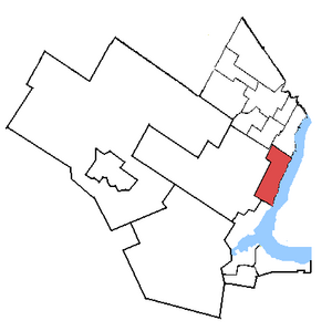
Oakville (federal electoral district)
Federal electoral district in Ontario, Canada
Distance: Approx. 1067 meters
Latitude and longitude: 43.459,-79.678
Oakville is a federal electoral district in Ontario, Canada, that has been represented in the House of Commons of Canada since 1997. After the 2022 Canadian federal electoral redistribution, the riding will be abolished and divided into Oakville East and Oakville West for the 45th Canadian federal election.

Knox Presbyterian Church (Oakville, Ontario)
Church in Ontario, Canada
Distance: Approx. 1380 meters
Latitude and longitude: 43.4464,-79.6666
Knox Presbyterian Church, Oakville is a Presbyterian Church in Canada congregation, and located at 89 Dunn Street at Lakeshore Road (Highway 2) in downtown Oakville, Ontario, Canada.

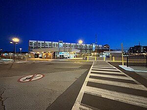
Oakville GO Station
Railway station in Ontario, Canada
Distance: Approx. 546 meters
Latitude and longitude: 43.455,-79.6825
Oakville GO Station is a GO Transit railway station and bus station in Oakville, Ontario, Canada. It is colocated and shares platforms with Via Rail's Oakville railway station. It is a stop on GO's Lakeshore West line train service and, until October 2007, served as the western terminus for weekend service.

Sixteen Mile Creek (Halton Region)
River in Ontario, Canada
Distance: Approx. 1819 meters
Latitude and longitude: 43.43944444,-79.66583333
Sixteen Mile Creek is a river in Halton Region in the Greater Toronto Area of Ontario, Canada. It is in the Great Lakes Basin, and flows from the Niagara Escarpment through the towns of Milton and Oakville to Lake Ontario. The creek is named for the distance from the river's mouth to the western end of Lake Ontario.
White Oaks Secondary School
High school in Oakville, Ontario, Canada
Distance: Approx. 2098 meters
Latitude and longitude: 43.46333333,-79.70138889
White Oaks Secondary School (WOSS) is a secondary school located in Oakville, Ontario, Canada. The school has north and south campuses, across the road from each other. The north campus used to be attended by students who had different levels and types of capabilities than those of the south campus.
Burloak Canoe Club
Canoe and kayak racing club in Ontario, Canada
Distance: Approx. 896 meters
Latitude and longitude: 43.4453,-79.674
The Burloak Canoe Club is a flatwater canoe/kayak racing club located in Oakville, Ontario. It serves the communities of Burlington and Oakville and provides a variety of canoe-based activities for local residents focusing primarily on the two disciplines of sprint canoe and sprint kayak. Burloak Canoe Club is located on Navy Flats along the banks of Sixteen Mile Creek and boasts a sizable building that caters not only to sport but to special events as well.

Oakville Place
Shopping mall in Ontario, Canada
Distance: Approx. 1323 meters
Latitude and longitude: 43.461523,-79.687423
Oakville Place Shopping Centre is an indoor shopping mall in Oakville, Ontario, Canada. Opened in 1981, the mall is the only major indoor mall in the Town of Oakville. The mall is approximately 42,000 square metres (452,000 sq ft).
Oakville Armoury
Drill Hall / Armoury in Ontario, Canada
Distance: Approx. 1299 meters
Latitude and longitude: 43.4445,-79.6688
Oakville Armoury is a Canadian Department of National Defence facility located at 90 Thomas Street in Oakville, Ontario. The nearest major intersection is Lakeshore Rd and Trafalgar Rd. It is the home of 'A' company, The Lorne Scots (Peel, Dufferin and Halton Regiment) and the 1188 Lorne Scots Royal Canadian Army Cadet Corps.
St. Mildred's-Lightbourn School
Independent school in Oakville, Ontario, Canada
Distance: Approx. 2013 meters
Latitude and longitude: 43.46475,-79.66829
St. Mildred's-Lightbourn School (commonly referred to as just St. Mildred's and abbreviated to SMLS) is an independent all-girls school in Oakville, Ontario, Canada with approximately 550 students from Junior Kindergarten to Grade 12.

Oakville (provincial electoral district)
Provincial electoral district in Ontario, Canada
Distance: Approx. 1067 meters
Latitude and longitude: 43.459,-79.678
Oakville is a provincial electoral district in Ontario, Canada, that has been represented in the Legislative Assembly of Ontario since 1999.

Turner Chapel (Oakville, Ontario)
Church building in Oakville, Canada
Distance: Approx. 1244 meters
Latitude and longitude: 43.44129,-79.67344
Turner Chapel was an African Methodist Episcopalian Church located at 37 Lakeshore Road West in Oakville, Ontario, Canada. It was established in 1891 by Samuel Adams and his brother-in-law Reverend William Butler. An earlier structure, built on the east side of Sixteen Mile Creek, had burned down.
Weather in this IP's area
overcast clouds
-11 Celsius
-18 Celsius
-12 Celsius
-10 Celsius
1027 hPa
62 %
1027 hPa
1009 hPa
10000 meters
4.63 m/s
200 degree
100 %